Hurricane Tammy could strengthen, Tropical Depression 21 bringing heavy rain to Nicaragua
The National Hurricane Center is tracking two systems: Hurricane Tammy in the Atlantic and the remnants of Tropical Depression 21, according to the latest advisory from the National Hurricane Center.
The remnants of the tropical depression are bringing heavy rain to Nicaragua. The depression has dissipated and no further advisories from the National Hurricane Center will be issued.
Hurricane Tammy could strengthen slightly over the next day or two, but is expected to weaken and become post-tropical Thursday.
The Florida Division of Emergency Management said while Tammy poses no direct threat to Florida over the next five days, ocean swells and breezy winds can be expected through the rest of the week across the East Coast due to high pressure along the U.S. East Coast and Tammy.
Two names remain on the 2023 list of storms: Vince and Whitney. Hurricane season doesn't end until Nov. 30, although storms can and do form any time.
Powerful hurricanes: Scientist: rapidly intensifying hurricanes 'particularly concerning' for coastal communities
This season has been above the historical average when it comes to named storms. During an average hurricane season, 14 named storms form in the Atlantic basin, which covers the Atlantic Ocean, Caribbean Sea and Gulf of Mexico.
There have been 19 named storms so far in the 2023 Atlantic hurricane season, along with a 20th unnamed storm that developed in January.
Tammy no threat to US: Tammy is born and storm season odds shift in our favor; but a spooky pattern may emerge
Here's the latest update from the NHC as of 5 p.m.:
Hurricane Tammy: Forecast path

Special note on the NHC cone: The forecast track shows the most likely path of the center of the storm. It does not illustrate the full width of the storm or its impacts, and the center of the storm is likely to travel outside the cone up to 33% of the time.
Location: 565 miles south-southeast of Bermuda; 1,208 miles east of Daytona Beach
Maximum sustained winds: 75 mph
Movement: northeast at 8 mph
At 5 p.m., the center of Hurricane Tammy was located near latitude 24.6 North, longitude 61.7 West. Tammy is moving toward the northeast near 8 mph, and this general motion is expected to continue through Wednesday. A turn toward the north at a slower forward speed is forecast to begin on Thursday night or Friday.
Maximum sustained winds are near 75 mph, with higher gusts. Slight strengthening is possible during the next day or so, followed by steady weakening. Tammy is forecast to become a post-tropical cyclone on Thursday.
Hurricane-force winds extend outward up to 25 miles from the center and tropical-storm-force winds extend outward up to 175 miles.
The estimated minimum central pressure is 987 mb.
No watches or warnings are in effect in connection with Tammy at this time.
Spaghetti models for Hurricane Tammy
Special note about spaghetti models: Illustrations include an array of forecast tools and models, and not all are created equal. The hurricane center uses only the top four or five highest performing models to help make its forecasts.
What to know about spaghetti models: Where is Tropical Storm Tammy heading? This controversial graphic has answers.
Who is likely to be impacted by Hurricane Tammy?
Tammy poses no direct threat to Florida over the next five days, at least. However, ocean swells and breezy winds can be expected through the rest of the week across the East Coast due to high pressure along the U.S. East Coast and distant Tammy, according to the Florida Division of Emergency Management.
Elsewhere, the forecast calls for:
Surf: Swells generated by Tammy will continue to affect portions of the Leeward Islands, the British and U.S. Virgin Islands, and Puerto Rico during the next few days. These swells are likely to cause life-threatening surf and rip current conditions.
Forecasters urge all residents to continue monitoring the tropics and to always be prepared.
Tropical Depression 21: Forecast path

Location: 130 miles north-northwest of Bluefields, Nicaragua
Maximum sustained winds: 25 mph
Movement: west-northwest at 3 mph
At 11 a.m., the remnants of Tropical Depression 21 were located near latitude 13.6 North, longitude 84.8 West. The remnants are moving toward the west-northwest near 3 mph and gradual turn toward the west is expected soon.
Maximum sustained winds are near 25 mph, with higher gusts.
The estimated minimum central pressure is 1007 mb.
The remnants of the tropical depression are expected to produce additional rainfall totals of 4 to 8 inches with maximum amounts of 12 inches across Nicaragua and 2 to 4 inches with maximum amounts of 6 inches across southern and eastern Honduras.
These rains are likely to produce flash and urban flooding, along withmudslides in areas of higher terrain.
Weather watches and warnings issued in Florida
When is the Atlantic hurricane season?
The Atlantic hurricane season runs from June 1 through Nov. 30.
When is the peak of hurricane season?
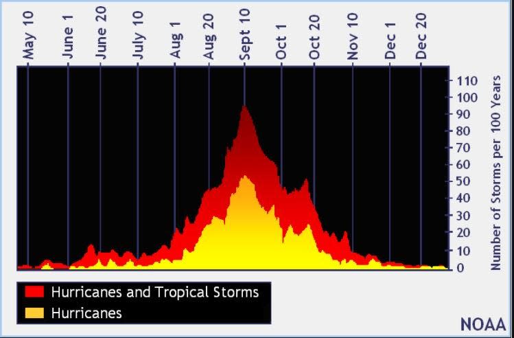
The peak of the season is Sept. 10, with the most activity happening between mid-August and mid-October, according to the Hurricane Center.
Tropical forecast over the next seven days
Excessive rainfall forecast
What's out there?
Systems currently being monitored by the National Hurricane Center.

Noaa
Embedded content: https://www.nhc.noaa.gov/xgtwo/two_atl_0d0.png?052051
What's next?
We will continue to update our tropical weather coverage daily. Download your local site's app to ensure you're always connected to the news. And look at our special subscription offers here.
This article originally appeared on Treasure Coast Newspapers: NHC tracking Hurricane Tammy, Tropical Depression 21. Forecast path

