Hurricane Tammy pounding the Leeward Islands. See the latest spaghetti models
Hurricane Tammy is bringing strong winds and heavy rains across the Leeward Islands as the center moved very close to Antigua.
Tammy is a Category 1 hurricane with maximum sustained winds of 85 mph, according to the most recent advisory from the National Hurricane Center.
The NHC is also tracking a system in the southwestern Caribbean that has a low chance of developing.
The center of Tammy will move near or over portions of the Leeward Islands through tonight, and then move north of the northern Leeward Islands on Sunday.
Hurricane warnings and watches, along with tropical storm watches and warnings, have been issued for areas in Tammy's path.
Tammy is threatening the Lesser Antilles with downpours, flooding, rip currents and damaging winds, according to AccuWeather.
"The heavy rain and strong winds can bring damage to the islands, especially to weakened structures," AccuWeather Senior Meteorologist Dan Pydynwoski said. "There can also be power outages and downed trees and power lines."
The National Hurricane Center predicts Tammy could see sustained winds up to 100 mph within the by Monday morning, which would make it a Category 2 hurricane.
AccuWeather expects the storm will stay east of the mainland United States and Bermuda as the winds gradually weaken next week.
More on hurricane season: Tammy is born and storm season odds shift in our favor; but a spooky pattern may emerge
The Atlantic list of storm names for 2023 is down to just two: Vince and Whitney. Hurricane season doesn't end until Nov. 30, although storms can and do form any time.
Here are the latest details on Tammy, according to the NHC's 5 p.m. advisory.
Where is Hurricane Tammy?

Special note on the NHC cone: The forecast track shows the most likely path of the center of the storm. It does not illustrate the full width of the storm or its impacts, and the center of the storm is likely to travel outside the cone up to 33% of the time.
Location: 35 miles east-southeast of Antigua; 1,493 miles southeast of West Palm Beach
Maximum sustained winds: 85 mph
Movement: North-northwest at 10 mph
Minimum central pressure: 988 mb
At 5 p.m., the center of Hurricane Tammy was located near latitude 17.0 North, longitude 61.3 West. Tammy is moving toward the north-northwest near 10 mph, and this general motion is expected through Sunday, followed by a turn toward the north on Monday.
On the forecast track, the center of Tammy will move near or over portions of the Leeward Islands through early Sunday, then move north of the northern Leeward Islands by Sunday afternoon.
Maximum sustained winds are near 85 mph with higher gusts. Slow strengthening is possible over the next few days.
Hurricane-force winds extend outward up to 25 miles from the center, and tropical storm-force winds extend outward up to 125 miles.
The minimum central pressure based on data collected from the Air Force and NOAA Hurricane Hunters is 988 millibars.
Anything greater than 979 mb is one indicator a storm could cause minimal damage. According to the NHC, the minimum central pressure of a storm is not necessarily a hazard, but it could indicate whether a storm will intensify in the future. Strengthening usually follows a drop in pressure, and a weakening usually follows an increase in pressure.
Spaghetti models for Hurricane Tammy
This auto-updated graphic shows how various spaghetti models are tracking Hurricane Tammy:
If the storm tracker is not not loading, click here.
Special note about spaghetti models: Illustrations include an array of forecast tools and models, and not all are created equal. The hurricane center uses only the top four or five highest performing models to help make its forecasts.
What to know about spaghetti models: Where is Hurricane Tammy heading? This controversial graphic has answers.
Watches and warnings in effect for Hurricane Tammy
A hurricane warning is in effect for:
Antigua, Barbuda, Montserrat, St. Kitts, Nevis, and Anguilla
St. Maarten
St. Martin and St. Barthelemy
A hurricane watch is in effect for:
Saba and St. Eustatius
A tropical storm warning is in effect for:
Saba and St. Eustatius
A tropical storm watch is in effect for:
British Virgin Islands
Who is likely to be impacted from Hurricane Tammy?
No impacts to Florida or the rest of the U.S. are expected at this time from Hurricane Tammy.
Elsewhere, the forecast calls for:
WIND: Hurricane conditions are expected to spread northward across the Leeward Islands through tonight. Tropical storm conditions are expected within the tropical storm warning areas through tonight, and hurricane conditions are possible in the hurricane watch areas through tonight. Tropical storm conditions are possible in the British Virgin Islands tonight and Sunday.
RAINFALL: Tammy is expected to produce the following storm total rainfall:
Leeward Islands: 4 to 8 inches with maximum amounts of 12 inches
Martinique and Dominica: Additional 2 to 4 inches with maximum amounts of 6 inches
British and U.S. Virgin Islands into eastern Puerto Rico: 1 to 2 inches with maximum amounts of 4 inches
These rains may produce isolated flash and urban flooding, along with isolated mudslides in areas of higher terrain.
STORM SURGE: Storm surge could raise water levels by as much as 1 to 3 feet above normal tide levels near where the center of Tammy moves across the Leeward Islands. Near the coast, the surge will be accompanied by large and dangerous waves.
SURF: Swells generated by Tammy will continue to affect portions of the Lesser Antilles during the next few days. These swells are likely to cause life-threatening surf and rip current conditions. Please consult products from your local weather office.
Forecasters urge all residents to continue monitoring the tropics and to always be prepared.
Key messages from the Hurricane Center: What you need to know about Tropical Storm Tammy
Hurricane and tropical storm conditions are expected in portions of the Leeward and northern Windward islands through early Sunday.
The heaviest rains from Tammy will continue over the Leeward Islands through Sunday. This rainfall may produce isolated flash and urban flooding, along with isolated mudslides in areas of higher terrain.
A storm surge could produce coastal flooding in areas of onshore winds as the center of Tammy moves near or over the Leeward Islands. Near the coast, the surge will be accompanied by large and dangerous waves.
Looking ahead: Maximum winds forecast for Tropical Storm Tammy
12 hours: 85 mph
24 hours: 90 mph
36 hours: 100 mph
48 hours: 100 mph
60 hours: 100 mph
72 hours: 100 mph
96 hours: 85 mph
120 hours: 70 mph
What else is out there and where is it?
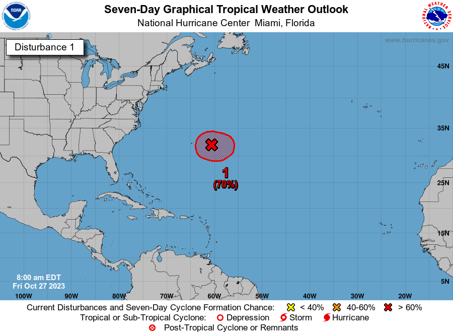
A broad area of low pressure located over the southwestern Caribbean continues to produce disorganized showers and thunderstorms. Some slow development of this system is possible before it moves inland over Central America by late Monday.
Formation chance through 48 hours: low, 20 percent.
Formation chance through 7 days: low, 20 percent.
Watches and warnings issued in Florida
When is the Atlantic hurricane season?
The Atlantic hurricane season runs from June 1 through Nov. 30.
When is the peak of hurricane season?
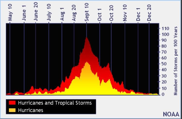
The peak of the season is Sept. 10, with the most activity happening between mid-August and mid-October, according to the Hurricane Center.
Tropical forecast over the next seven days
Excessive rainfall forecast
What's out there?
Systems currently being monitored by the National Hurricane Center.

Noaa
Embedded content: https://www.nhc.noaa.gov/xgtwo/two_atl_0d0.png?052051
Helpful hurricane resources and links
Get your home ready: Here is how to prepare your home for a hurricane, from well in advance to just before a storm's arrival
Need to prepare for a hurricane? Here is what you should have in a disaster supply kit
Hurricane preparedness list: If a storm is coming, here is what you need to do now
Hurricanes, typhoons, and cyclones: What's an invest and why do they keep saying tropical cyclone?
Officials encourage residents to assemble a hurricane kit early, storing enough supplies to last at least three days. Doing so ensures there are adequate supplies available on store shelves and prevents a rush - and shortages - that regularly occur when a storm is imminent.
What's next?
We will continue to update our tropical weather coverage daily. Download your local site's app to ensure you're always connected to the news. And look at our special subscription offers here.
This article originally appeared on The Daytona Beach News-Journal: NHC tracking Hurricane Tammy, system in Caribbean: forecast path

