Hurricane Teddy keeps strengthening, on track to Bermuda. Two depressions may also form
A strengthened Hurricane Sally made landfall in Alabama early Wednesday but quickly weakened to a tropical depression by nights end, while trouble may be coming for Bermuda as Hurricane Teddy is forecast to strengthen.
As for the other two named systems, Paulette was no longer being tracked and Tropical Storm Vicky was shrinking and poised to weaken Thursday.
Here’s what to know:
Two tropical depressions forecast to form in the Atlantic

One of the disturbances, described as an area of low pressure, was producing showers and thunderstorms about a few hundred miles south of the Cabo Verde Islands, according to the hurricane center.
It was moving west-northwestward at 10 to 15 mph and was forecast to turn into a tropical depression in the next few days, according to the hurricane center. It had a 40 percent chance of development in the next two days and 60 percent in the next five days, as of the 8 p.m. update.
The other two disturbances are on opposite sides of the Atlantic. One was producing showers and thunderstorms over the southwestern Gulf of Mexico and was beginning to show signs of organization, according to Wednesday’s advisory.
“Upper-level winds are forecast to gradually become more conducive for development, and a tropical depression is likely to form late this week or over the weekend while the low meanders over the southern Gulf of Mexico,” forecasters wrote. It had a 50 to 70 percent chance of formation in the next two to five days.
The other disturbance, described as a non-tropical area of low pressure, is over the far northeastern Atlantic Ocean and was a few hundred miles northeast of the Azores, according to the hurricane center. It had about a 10 percent chance of forming anytime this week.
“This system is forecast to move east-southeastward and then northeastward at about 10 mph over the next day or two, and its chances of acquiring some subtropical characteristics before it reaches the coast of Portugal late Friday appear to be decreasing,” forecasters wrote.
Listen to today's top stories from the Miami Herald:
Subscribe: Apple Podcasts | Spotify | Amazon Alexa | Google Assistant | More options
Hurricane Sally makes landfall in Alabama
Sally made landfall as a Category 2 hurricane near Gulf Shores, Alabama, just before 6 a.m. EDT Wednesday, with maximum sustained winds near 105 mph, according to the National Hurricane Center. The slow-moving storm brought heavy rain, dangerous storm surge and historic and dangerous flooding from the Florida Panhandle to Mississippi.
Gulf Shores, AL is in the eye of Hurricane Sally. This is a 6:30 a.m. map. Look at all the rain pounding the Florida panhandle. I'm also watching the water levels continuing to rise from Pensacola to Destin, FL. pic.twitter.com/yTlCugpyhD
— Bay News 9 Weather (@bn9weather) September 16, 2020
By 11 p.m., Sally weakened to a tropical depression, forecasters said. To learn more about Hurricane Sally, click here.
Hurricane Teddy keeps strengthening, on track to Bermuda
Bermuda, which is still recovering from being struck by Hurricane Paulette a few days ago, might have another storm coming its way.
Hurricane Teddy, a Category 2 storm, was quickly intensifying and was expected to strengthen into a Category 3 hurricane as it continued moving toward the northwest near 13 mph in the Atlantic Wednesday, according to the National Hurricane Center’s 11 p.m. advisory.
Forecasters said the storm is no longer expected to strengthen into a Category 4 this week, in part due to the cool waters left in Hurricane Paulette’s wake. On the forecast track, it’s expected to be a strong Category 2 storm, near Category 3 level strength, by the time it nears the island Monday.
“Teddy has been a perplexing hurricane thus far,” forecasters said. “The track forecast remains straightforward the the next three days, with the guidance in good agreement that a mid-tropospheric high over the central Atlantic will drive the hurricane northwestward toward the western Atlantic.”
“Unfortunately, this change does increase the threat to Bermuda, which was just hit by Hurricane Paulette but remember the average track error at five days is roughly 200 miles,” forecasters wrote.
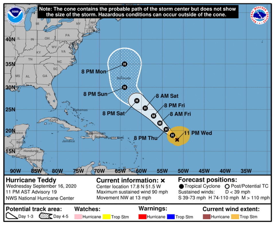
As of 11 p.m. Wednesday, Teddy’s maximum sustained winds were near 90 mph with higher gusts. Its hurricane-force winds were extending up to 35 miles from the center and tropical-storm-force winds were extending up to 255 miles.
There were no coastal warnings or watches in effect.
Forecasters cautioned that large swells generated by Teddy were expected to reach the Lesser Antilles and the northeastern coast of South America Wednesday and should spread to the Greater Antilles, the Bahamas and Bermuda by Friday. These swells will likely cause life-threatening surf and rip current conditions, according to the hurricane center.
What about Hurricane Paulette and Tropical Storm Vicky?
Hurricane Paulette became an extratropical cyclone Wednesday morning as it continued toward the east-northeast near 29 mph in the open waters of the Atlantic, according to the hurricane center. Paulette was then forecast to slow down and turn toward the south-southeast late Thursday and Friday. It will then eventually weaken back into a tropical storm. The 11 a.m. update was the last forecast the hurricane center will issue for Paulette.
Paulette’s swells will likely continue causing life-threatening surf and rip current conditions to Canada, Bermuda, the Bahamas, and portions of the East Coast of the United States through Wednesday night, forecasters said.
Tropical Storm Vicky was expected to weaken in the next couple of days as it continues moving toward the west-northwest near 10 mph. It’s forecast to become a remnant low on Thursday or Friday.

