Hurricane watch in place as Subtropical Storm Nicole strengthens, takes aim for Florida
Brevard County residents are bracing as Subtropical Storm Nicole continues to gather strength, churning northwest toward Florida’s east coast with life-threatening surf, tropical-force winds, and heavy rains.
The storm could strengthen to a Category 1 hurricane sometime Wednesday and potentially make landfall anywhere from Miami to Cape Canaveral, said Jessie Smith, a meteorologist with the National Weather Service in Melbourne.
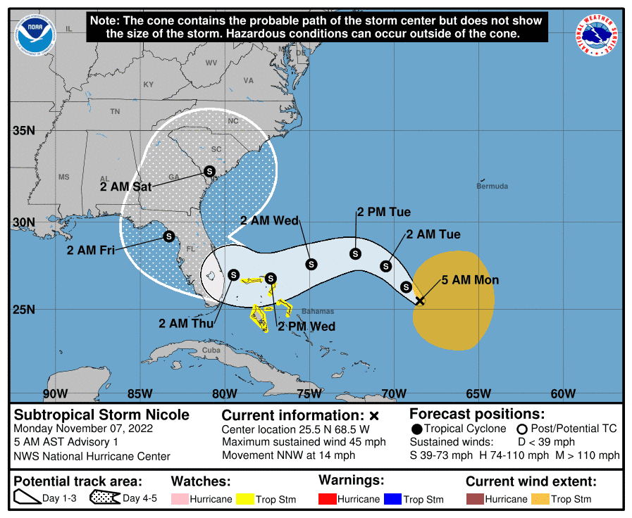
A hurricane watch — meaning hurricane-force winds are possible within a 48-hour period — was issued for Brevard and neighboring coastal counties Monday as the storm followed an uncertain trajectory toward the state.
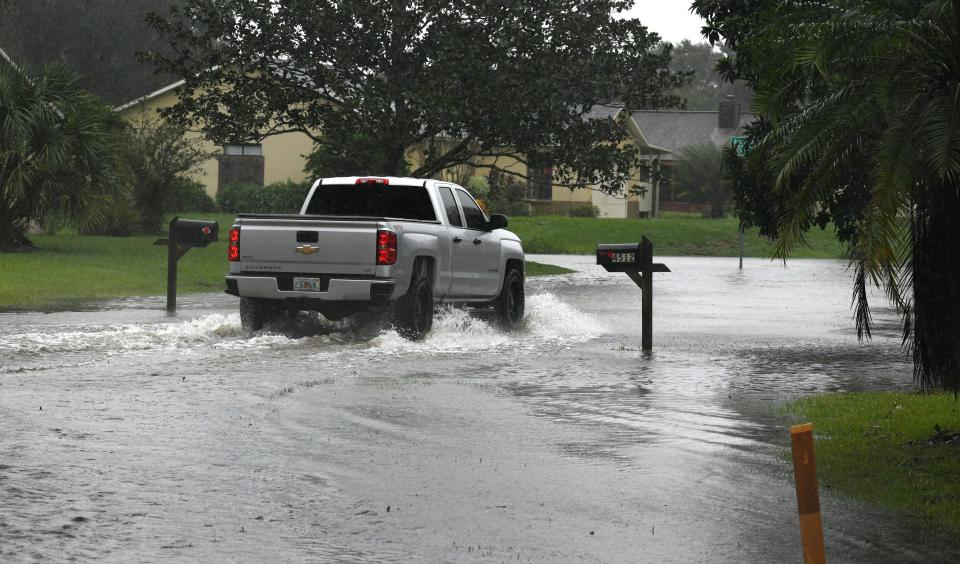
The National Weather Service, in its 11 a.m. surge warning, said that “major beach erosion with heavy surf breaching dunes” could be expected along with moderate damage to moorings, docks, and other beachside structures along the east coast. Tornadoes are also a possibility, the weather service reported.
The storm could also strengthen into a hurricane as it feeds off of the warm waters around the Bahamas.
In regard to storm chances, Tim Sedlock, a meteorologist with the National Weather Service in Melbourne, said: “It could come close but it is forecast to become a fairly strong tropical storm at this point, although that’s not in the realm of impossibility.”
A storm surge watch — with seas possibly seeing 19-to 29-foot offshore waves — was also issued for the east Florida coast, including Brevard.
The storm, the 14th named system of the year, formed Monday off the Bahamas.
The latest Monday advisory showed Nicole becoming better organized, with maximum sustained winds of 45 mph, and moving toward the north-northwest at 14 mph, according to the National Hurricane Center. By Monday morning, the storm was 721 miles east of West Palm Beach.
Already, the National Weather Service in Melbourne has issued several advisories for Brevard, including a coastal flood watch, meaning rough seas could inundate beaches from Daytona Beach to the Space Coast and south.
Tropical storm conditions are possible Wednesday night and into Thursday, weather officials said.
The storm could also drop 4 to 6 inches of rainfall on Brevard, which took weeks to recover from flooding brought on by Hurricane Ian. Some parts of the county could get up to 8 inches of precipitation. Weather along the Space Coast will gradually begin to deteriorate beginning overnight Tuesday.
That means residents already wearied by Hurricane Ian in September need to prepare for another tropical storm that could bring heavy rains, winds, and erosion by mid-week, Florida Department of Emergency Management officials advised Sunday.
Several agencies and entities, from the Port Authority to Health First, were expected to go over plans or make other decisions as the storm’s intensity and path become clearer.
Patrick Space Force Base entered HURCON V in preparation for the arrival of strong winds of 58 mph later this week. The Melbourne-Orlando International Airport was also reviewing storm preparations.
Brevard County officials have not formalized any plan as of yet for preparing for the coming storm but meetings are taking place to see what actions need to be taken, according to Rachel Horst, the public information officer for the county.
For now, officials are asking the public to take steps to prepare for its arrival, such as stocking their hurricane kit and staying up to date on the latest information from emergency management. They can do that by sending a text message to 888777.
Flood warnings were issued for the St. Johns River, which saw flooding after Ian.
Election Day will see a 30% chance of rain before polls close at 7 p.m. By Tuesday night, those rain chances will be bumped to 50%. Nicole could have the most impact Wednesday night and Thursday, weather officials reported.
Writer Ralph Chapoco contributed to this story. J.D. Gallop is a criminal justice/breaking news reporter at FLORIDA TODAY. Contact Gallop at 321-917-4641 or jgallop@floridatoday.com. Twitter: @JDGallop.
Support local journalism. Subscribe today.
Support local journalism. Subscribe today.
This article originally appeared on Florida Today: Brevard County could see heavy rains from Subtropical Storm Nicole

