There was an earthquake off Cape Canaveral. Does Florida get earthquakes?
Here in Florida, we get hurricanes but at least we can see them coming. We're not used to earthquakes.
Which is why the 4.0 magnitude quake that rattled parts of Florida's Space Coast Wednesday night a few hours before NASA's PACE spacecraft launch was such a surprise.
The earthquake rumbled about 100 miles east of Cape Canaveral about 10:48 p.m., according to the U.S. Geological Survey, with a shallow depth of about six miles. Residents from Merritt Island to Palm Bay reported shaking.
Earthquakes happen somewhere in the world every day, experts say. Last week the USGS released the latest National Seismic Hazard Model which showed that nearly 75% of the United States — including parts of Florida — could be impacted by a damaging earthquake.
So should Floridians be more concerned the ground will start moving?
Answer: Probably not too much. But it's happened before.
Does Florida get earthquakes?
Yes, but very rarely. Florida ties North Dakota as the state with the fewest earthquakes per year. Between 1975 and 1995 the state was one of only four that recorded no earthquakes at all. (The others were Iowa, Wisconsin and North Dakota.)
Earthquakes are caused by sudden movement by tectonic plates that release energy in waves that travel through the earth's crust and cause shaking in the surface. But Florida is not located near any tectonic plate boundaries. The closest fault line to Florida runs through the Caribbean Sea, just north of Puerto Rico and the Dominican Republic and south of Cuba toward Guatemala.
They do happen, however, often from earthquakes strong enough to affect us even if they're not close by. In September 2020 Santa Rosa residents were shaken about by a 3.8 magnitude earthquake on the Florida/Alabama line just northwest of Mount Carmel. People in Jay, East Milton and even Navarre reported feeling the ground shake.
"I was on my couch asleep, and it was (shaking) so hard it woke me up," said Jay resident Candace Black. "My TV shook on the stand and the pictures on my wall also shook. It lasted about two to three minutes. I was very scared, I didn't know what was going on."
According to the USGS, nine earthquakes struck near that area the year before, between March 7 and April 14, 2019, ranging in intensity from a magnitude 1.9 to a magnitude 3.1. Before that, the area hadn't seen an earthquake in 20 years.
Shaking the Sunshine State: Does Florida, known for its storm threats, ever shake from earthquakes?
How likely is an earthquake in Florida?
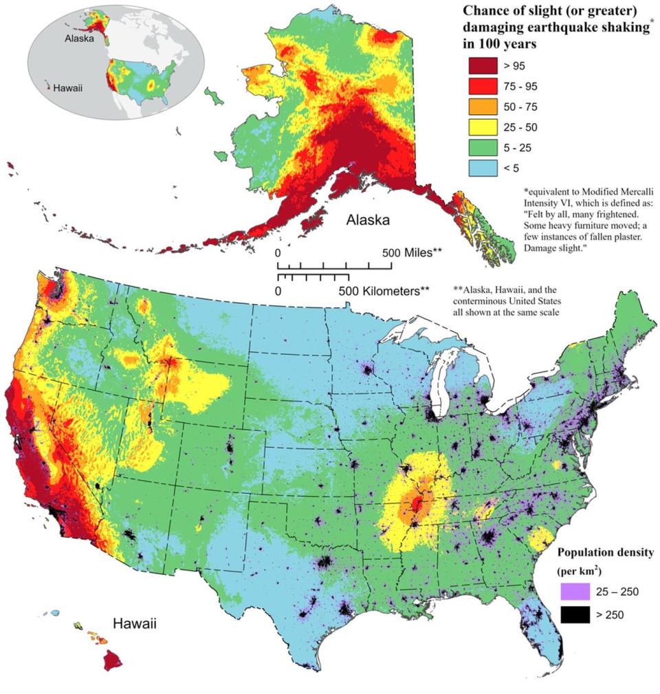
It's not a high percentage of risk in Florida, but in the USGS' new National Seismic Hazard Model map it's not zero.
In the update, based on a "massive collaborative effort" from more than 50 scientists and engineers and federal, state and local governments, most of Florida has a 5% chance or lower of experiencing a damaging earthquake in the next 100 years. But the Panhandle and an area of North Florida down to a line stretching from Jacksonville southwest to south of Cape Coral has a 5-25% chance, the agency said.
The latest USGS map is the first 50-state comprehensive assessment. Previous versions focused on either the contiguous U.S., Alaska or Hawaii.
"Earthquakes are difficult to forecast but we’ve made great strides with this new model," said Mark Petersen, USGS geophysicist and lead author of the study. "The update includes more faults, better-characterized land surfaces, and computational advancements in modeling that provide the most detailed view ever of the earthquake risks we face."
But don't start pulling your breakables off shelves yet. The new model shows greater chances of more damaging earthquakes along the central and northeastern Atlantic Coast corridor, but the Sunshine State is still at the low end of the threat spectrum. In the detailed USGS report, "Florida" is not mentioned once.
Shaking the coast: How many earthquakes have been felt on the Treasure Coast? More than one
What was Florida's largest earthquake?
In 1879, the largest recorded earthquake in Florida measured in at a 4.4 magnitude possibly centered in the Palatka area on the border of Putnam and Marion County in North Central Florida. The tremors were felt as far away as Tallahassee and Cedar Key. "Plaster was shaken down and articles were thrown from shelves at St. Augustine and, to the south, at Daytona Beach," according to USGS records.
The largest earthquake to affect Florida was in 2006, a 5.9 earthquake in the Gulf of Mexico that rocked Southwest Florida and reportedly shook some buildings in Cape Coral, but caused no serious damage.
What other earthquakes have hit Florida?
Most earthquakes in our area are minor ones, magnitude 3 and under — "magnitude" is the relative size of an earthquake, on the Richter scale — that residents might notice as a little shaking. Some notable Florida quakes:
January 1880: Shocks from two strong earthquakes near Cuba struck Key West.
August 1886: The famous Charleston, South Carolina quake that killed 60 and damaged thousands of buildings was felt throughout northern Florida, ringing church bells in St. Augustine and shaking towns along the east coast.
October 1900: On Halloween day, Jacksonville residents felt eight distinct shocks when a 3.5 magnitude quake hit.
November 1948: Captiva Island near Fort Myers was rattled and residents described hearing sounds like explosions in the distance.
November 1952: “On November 18, 1952, a slight tremor was felt by many at Quincy, a small town about 20 miles northwest of Tallahassee," U.S. Geological Survey records said. "Windows and doors rattled, but no serious effects were noted. One source notes, ‘The shock interfered with writing of a parking ticket.’ It didn’t say in what way.”
October 1997: A 4.8 quake just north-northwest of Flamaton, Alabama, was felt in Pensacola.
January 2014: A 5.1 quake happened just off the northern coast of Cuba that sent shock waves through Key West.
June 11, 2001: A 3.3 quake was reported 86 miles east-northeast of St. Augustine.
March 2019: The U.S. Geological Survey reported a magnitude 2.6 earthquake occurred in Santa Rosa County, just south of the Alabama border.
March 2019: Five earthquakes within a month were reported in Escambia County from the Flamaton, Alabama area.
Sept. 3, 2020: A 3.8 earthquake was detected west-northwest of Jay, Florida.
Feb. 7, 2024: A 4.0 earthquake was detected about 100 miles east of Cape Canaveral.
Did the U.S. Navy cause an earthquake off the Daytona Beach coast?
A magnitude 3.7 earthquake was recorded off the Florida coast, about 100 miles east-northeast of Daytona Beach Shores, in July 2016.
But it was found to have been triggered by a manmade explosion designed to test the seaworthiness of a new U.S. Navy vessel, so it doesn't really count. A similar "quake" was reported by the Geological Survey on June 10, 156 nautical miles east-northeast of Ormond-by-the-Sea, the same day Navy reported conducting a shock trial on the USS Jackson.
Samantha Neely, Fort Myers News-Press, contributed to this story.
This article originally appeared on The Daytona Beach News-Journal: Florida earthquake: 4.0 quake rattles Cape Canaveral coast

