Hurricanes Franklin and Idalia will brush NC this week. Here’s what to expect
Two hurricanes will brush North Carolina this week, bringing the potential for rip currents along the coast, flash flooding in Southeastern North Carolina and heavy rain as far inland as I-95 midweek.
Hurricane Franklin will bring rough seas
▪ NOAA meteorologist say Hurricane Franklin will stay several hundred miles offshore as it passes between North Carolina and Bermuda starting Monday night. But forecasters say that will be close enough for the storm to generate rough seas, especially in the area from Cape Hatteras to Cape Fear.
In that area, seas will be up to 6 feet Monday, forecasters said, increasing Monday night to 9 feet and running up to 10 feet through Tuesday night.
▪ With those rough seas comes the risk of rip currents, with the highest risk in the stretch from Kill Devils Hills to Cape Lookout, according to NOAA maps.
Idalia timeline: Moving in on Wednesday
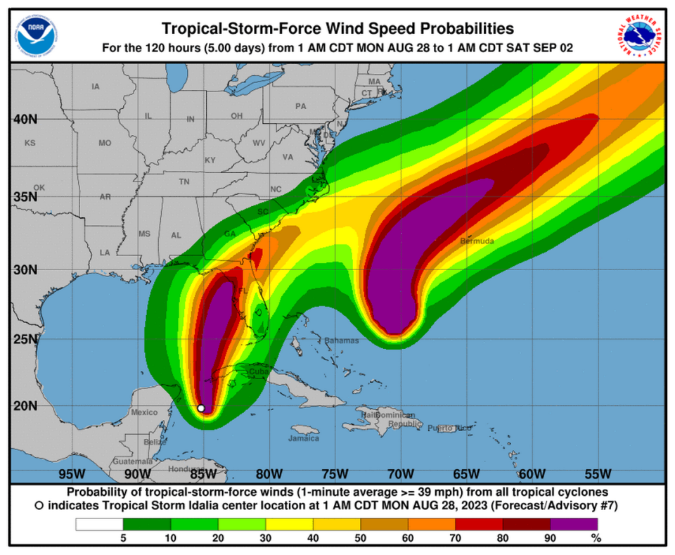
▪ Idalia – which National Hurricane Center meteorologists pronounce ee-DAHL-yuh – is expected to become a hurricane Monday afternoon. Forecasters say it will begin to move through the Gulf of Mexico Monday and Tuesday toward the point where the Florida panhandle meets the peninsula.
By the time it makes landfall in that area on Wednesday, forecasters say the storm could be a Category 3 hurricane with peak winds of 129 mph.
▪ NOAA says the storm will move to the northeast, bringing tropical storm conditions to Georgia, South Carolina and North Carolina Wednesday night. Local forecasts show more than 6 inches of rain is possible along the N.C. coast from the South Carolina line to Hatteras.
▪ Flash flooding is possible, especially in the area of Southeastern North Carolina from Lumberton to Carteret County, including Wilmington and Jacksonville.
▪ The marine forecast calls for winds of up to 40 mph Wednesday night through Friday along the North Carolina coast, with waves up to 13 feet.
▪ Idalia could bring 4 to 6 inches of rain as far inland as I-95.
▪ From I-95 to just east of Wake County, forecasters are calling for an inch to 4 inches of rain. From Wake County to the mountains rainfall amounts vary from none to as much as 4 inches.
Will Raleigh get much rain?
Raleigh is expected to get very little rain from Idalia, except from isolated thunderstorms.
What about the weather on Labor Day Weekend?
Conditions should improve on Thursday, with clearing skies and cooler temperatures compared to recent weeks.
North Carolina beach forecasts are calling for sunny skies and highs in the low- to mid-80s Friday through Monday, with lows in the 70s.
5 steps to take right now to be safe and comfortable when a hurricane hits North Carolina
Here’s what colored flags at North Carolina and other U.S. beaches mean. How to stay safe.

