Packing a punch: Ian brought flooding, downed trees and power outages to Cape Fear region
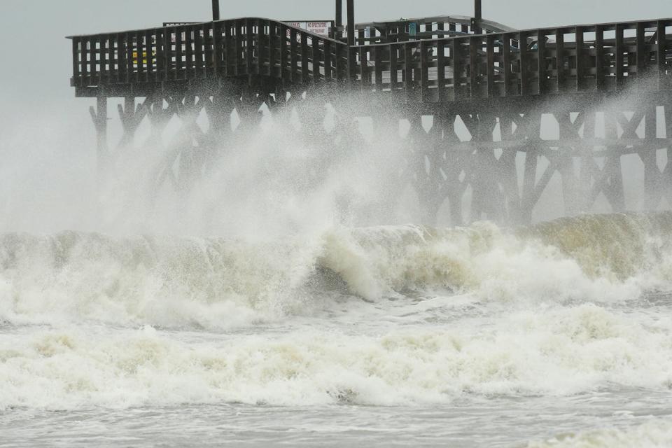
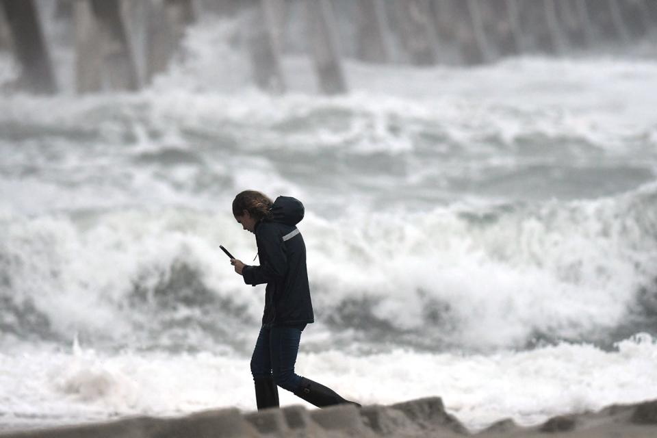
Rain bands from Hurricane Ian lashed Southeastern North Carolina Friday as storm-driven waves brought heavy surf and erosion woes to area beaches. The threat of tornadoes was a lurking threat for most of Friday, and flooded roads − especially near the coast − became increasingly treacherous as the storm drew closer.
But with Ian making landfall more than 100 miles to the south in South Carolina, the Wilmington area appeared to be set to miss a major beating from the weakening hurricane that had carved a path of destruction across Florida 36 hours earlier.
Still, local officials warned residents to avoid any unneeded travel and be prepared to deal with downed vegetation and isolated power outages. They also said the impacts from Ian could continue into the weekend as rainfall amounts of up to 6 inches − less in inland locales − made its way into streams and rivers and began its slow slog toward the coast.
As of 10 p.m. Friday, weather stations monitored by N.C. State University reported 2.9 inches of rain had fallen in Castle Hayne and 46 mph wind gusts had been reported on Bald Head Island.
Ian made landfall near Georgetown, S.C., between Charleston and Myrtle Beach, just after 2 p.m. Friday as a strong Category 1 hurricane with maximum sustained winds of 85 mph, according to the National Hurricane Center. The storm was forecast to weaken to a tropical depression as it tracked across central South Carolina and approached the North Carolina state line early Saturday. In a change from earlier forecasts, Ian's path was expected to be more northerly as it moved inland, impacting Charlotte and the Triangle and Triad areas, pushing into Virginia and West Virginia late Saturday.
Flooded coastal roads
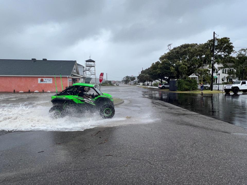
While Friday morning in the Cape Fear region started off with little more than some light gusts and periodic showers, conditions began to deteriorate around lunchtime and as high tide approached.
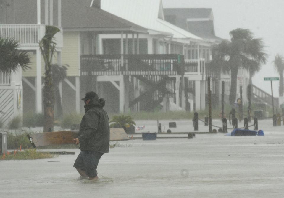
County emergency officials reported increased ponding in low-lying areas and downed trees blocking roads in some areas. Roads in low-lying areas, such as Southport's Yacht Basin and in Carolina Beach, closed as rising water levels driven by Ian's storm surge coupled with rainwater left them overwashed. Some roads prone to flooding, including Canal Drive in Carolina Beach, had actually closed Thursday as high tide coupled with Ian's storm surge sent floodwaters cascading onto them.
"Our traditional spots in the county are having issues," said Steve Still, director of New Hanover County’s Emergency Management, Friday morning.
SUPER STORMSIn a warming world, 'Cat 6' hurricanes could soon be coming to a coast near you
In Brunswick County, Sunset Beach officials closed the bridge that linked the southernmost barrier island in North Carolina to the mainland after the bridge's causeway was overwashed Friday afternoon.
Officials across the area said beach town residents should prepare for flooding, and overwash events were reported in Oak Island and Ocean Isle Beach early Friday. The weather service was predicting a storm surge inundation of 1-3 feet from Surf City to Little River, S.C. Beach erosion was a growing concern, but it would likely have to wait until the weekend to determine just how bad it was.
Emergency officials were particularly worried about motorists driving through flooded roads in beach towns and near rivers and other waterways, especially at night when it becomes even more difficult to gauge the extent of the flooding.
“When we have that storm surge push mid-afternoon into late evening, we’re going to start to see some water over the roadways in those areas,” Still said.
Power outages were also predicted to increase as the Ian moved closer to North Carolina. As of 10 p.m. Friday, website PowerOutage.us, which tracks electric customers without power across the country, was reporting 368,000 outages in North Carolina, with the most in Wake and Durham counties. There were 103,500 outages in South Carolina and 1.4 million customers without power in Florida, according to the website.
'We're here'
Wilmington residents seemed to be taking Ian's arrival in stride, particularly considering the destructive path the then powerful hurricane had cut across much of Florida.
It was a quiet downtown Wilmington over lunch Friday, with few if any windows were boarded up and a pile or two of sandbags placed halfheartedly in front of some doors on Water Street.
Damage was also minimal, with a broken tree limb at Front and Market and a few deep puddles on Water Street between Market and Princess streets.
Most businesses appeared to be open, with such popular restaurants as Front Street Brewery, Nikki's, and Rebellion all serving lunch.
At downtown's oldest bar, The Barbary Coast, longtime manager Ryan Smith was preparing to open at 1 p.m. as usual. Smith said he's seen several hurricanes in his 10 years at the Barbary, which was one of the first bars downtown to re-open after Florence in 2018.
At the Bakery 105 event space at Front and Orange streets, at least one Wilmington couple wasn't going to allow Hurricane Ian to ruin their big day. As the Designs by Amber Lanier florist set up decorations, manager Katie Swain helped prepare for a wedding scheduled for 5:30 p.m.
"We're here," Swain said. "Rain, snow or tropical storm."
As a quick-moving storm, Ian was expected to exit most of North Carolina by Saturday afternoon. The weekend forecast for Wilmington called for humid days with periods of cloud and sun and a slight chance of showers. Temperatures were projected to be in the upper 70s, with lows bottoming out near 60 degrees.
StarNews Staff Writers John Staton and Emma Dill contributed to this report. Reporter Gareth McGrath can be reached at GMcGrath@Gannett.com or @GarethMcGrathSN on Twitter. This story was produced with financial support from 1Earth Fund and the Prentice Foundation. The USA TODAY Network maintains full editorial control of the work.
This article originally appeared on Wilmington StarNews: Ian brings wet, windy conditions to NC coast as it arrives in Carolinas

