Ian on catastrophic collision course with Southwest Florida: A rain, surge, wind breakdown | WeatherTiger
Hurricane Ian has entered the Gulf of Mexico as a major hurricane, and is on a collision course with the Florida Gulf Coast between Tampa Bay and Fort Myers between Wednesday afternoon and early Thursday.
Ian will likely bring catastrophic wind and surge damage to southwest Florida, as well as broad and severe flooding rainfall impacts to much of the Florida peninsula through Friday.
As of the NHC’s 11 a.m. advisory, the center of Hurricane Ian has emerged from the north coast of Cuba and is located about 325 miles south of Tampa. Ian reached its westward apogee over Cuba, and is now moving a little east of due north now at about 10 mph.
Live updates from the EOC: Live Updates: Hurricane Ian's path, predictions and Florida Gov. DeSantis' latest
Live updates from Tallahassee:Tallahassee 'not out of the woods' as Category 3 Hurricane Ian eyes Florida
'This one feels scary': Sarasota and Manatee residents brace for direct hit from Hurricane Ian
Ian’s movement through Tuesday afternoon as tracked by Hurricane Hunter aircraft and Key West radar has nicked a little east of the NHC forecast track and most model guidance. As such, the NHC official forecast has adjusted south and east since Monday, and now calls for landfall between Tampa Bay and Charlotte Harbor Wednesday evening.
Category 4 jump likely coming this evening in a 'worst case scenario'
Maximum sustained winds are 115 mph for the moment, but will likely continue rising into early Wednesday. A clearing, perfectly symmetrical eye on satellite imagery and ongoing bursts of lightning in the northern eyewall are indicative that the NHC forecast for Category 4 intensity is likely to verify overnight.
Ian’s eastward shift narrows the range of possibilities for the hurricane. Realistic scenarios now range from a landfall Wednesday afternoon in the Fort Myers area, to crawl just offshore the Tampa Bay region by Thursday morning. Should Ian’s center remain over water, it is likely it would be close enough to the coast that impacts on the West Coast would be similar to (or worse) than a landfall.
After Ian moves north-northeast towards the coast on Wednesday, the departure of eastern U.S. steering trough likely means it will decelerate significantly and turn back north over Central Florida or scraping the Nature Coast on Thursday, and probably not clear out of Florida until early Saturday.
The expected landfall on Wednesday is the worst-case scenario for Southwest Florida. Ian’s maximum winds will probably crest overnight due to increasing shear, but meaningful disruption of the hurricane is unlikely before landfall.
Even if maximum winds edge downward a tick from the peak before coming ashore, as in the NHC forecast, in no way should that be construed as Ian weakening. Ian will strike as a major hurricane, only the fifth Category 3 or higher (and just 12th hurricane overall) to make a direct landfall between Hernando County and Fort Myers since 1851.
That means there are a lot of communities that are going to be tested by all four hurricane hazards — surge, wind, rain, and tornadoes — who have no modern reference point for such an event.
Hurricane Charley was a compact Category 4 sucker punch into Charlotte Harbor in 2004, causing a narrow swath of catastrophic wind damage extending into Central Florida.
However, Charley’s tiny size and forward speed of 20-25 mph limited its other hazards. Ian’s larger size and expected forward speed of around 5 mph on Thursday and Friday make for multiple widespread water hazards not observed during Charley.
Let’s go one-by-one through each of those hazards to get a full picture of the threat Ian poses to Florida:
A deadly storm surge event without living precedent
Ian will be a surge event unlike any hurricane in the modern era for Southwest Florida. The powerful windfield in Ian’s eastern semicircle will push a wall of water north onto the shallow Gulf continental shelf, and any last-minute miniscule reduction in Ian’s maximum winds will not reduce the volume of that onslaught one bit.
As such, Storm Surge Warnings are in place for essentially all of Florida’s Gulf Coast. NHC modeling is calling for 8 to 12 feet of surge between southern Tampa Bay and Bonita Beach, with 5 to 8 feet values further south and east.
This is life-threatening surge without living precedent in Southwest Florida: if you are told to evacuate, leave. You can hide from the wind, but you need to run from water.
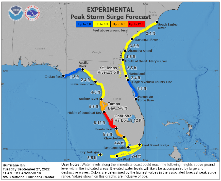
The most severe coastal flooding will occur near and southeast of where Ian’s center comes ashore, with much lesser inundations north and west of the eventual landfall point. If Ian does indeed make landfall south of Tampa Bay, the primarily offshore winds there would limit surge (but not freshwater or flash) flooding.
That would be one silver lining a track further east, though a path over or just west of the Bay that would put Tampa right back in the thick of catastrophic flooding is still possible. Don’t let your guard down there yet. The surge threat to the Nature Coast and Apalachee Bay has diminished with the shift east, but should still be monitored.
Finally, northeast Florida including the Jacksonville area can expect 3 to 6 feet of surge from strong onshore winds, particularly on Thursday. This area is also under a Storm Surge Warning.
Punishing winds will be far reaching through Florida
A landfall or track along the coast amplifies the expected wind damage from Ian along the Florida Gulf Coast.
With Ian expected to make landfall as a Category 3 on Wednesday thus not be weakening, hurricane-force winds are expected along the coast as far south as Naples, and north to the Tampa Bay area.
It is too early to know which sections of the Tampa to Fort Myers areas’ coastlines will receive Ian’s eyewall, where structurally damaging wind gusts exceeding 115 mph will be concentrated.
With forward motion slowing and turning north Wednesday night into Thursday, Ian’s eyewall could scrape an extended section of this coastline.

Hurricane-force wind gusts are also likely inland over Southwest Florida and potentially west Central Florida at the height of the storm, and an extended period of tropical-storm-force winds and gusts are expected in these areas through Thursday.
Due to Ian’s slow motion, East Central Florida is not likely to see a blast of hurricane-force winds as in Charley, but tropical-storm-force wind gusts in squalls are expected late Wednesday into Thursday.
North Central and Northeast Florida will also likely see tropical-storm-force onshore winds, particularly on Thursday and possibly extending into Friday. Occasional tropical-storm-force wind gusts are possible in bands in the Big Bend and eastern Panhandle Thursday and Friday, but nothing worse unless the track of Ian changes.
Ian's most widespread impact: Rainfall
When people think of hurricane threats, excessive rainfall and flooding isn’t necessarily the first thing that comes to mind. But it should be — nearly one-third of tropical cyclone-related casualties are caused by freshwater flooding.
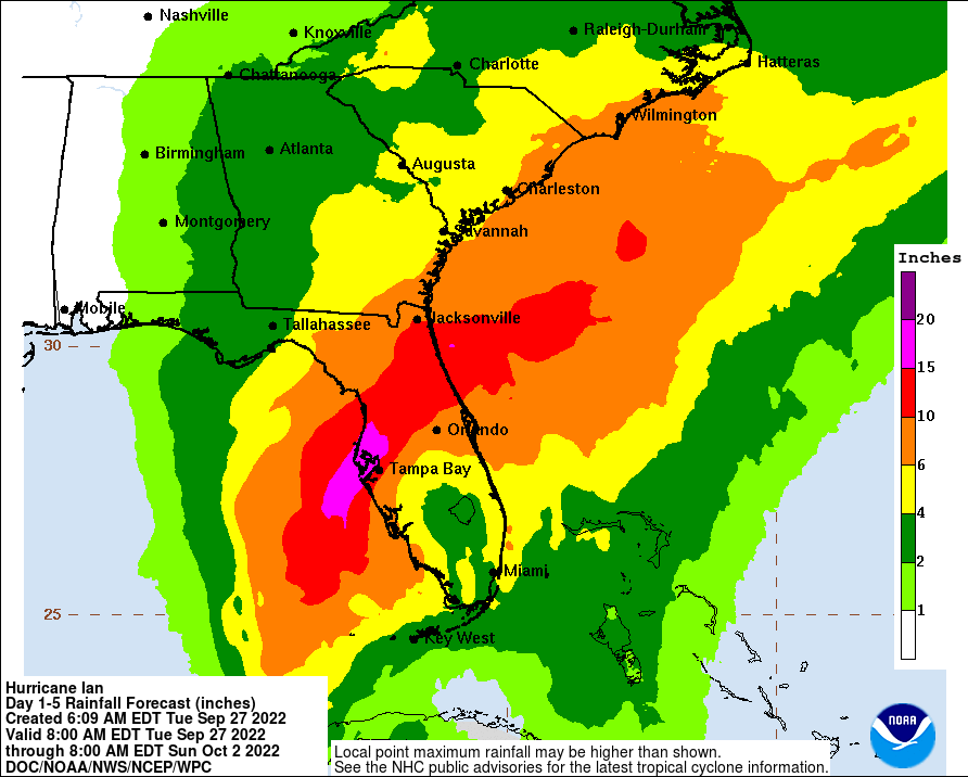
Heavy rainfall is going to be the most widespread impact from Ian. Two to five inches of rain have already fallen from outer bands in South Florida as of Tuesday afternoon, and steady, soaking rainfall with intermittent torrential downpours will continue through Ian’s excruciating 48-to-72-hour trek across the state.
Current guidance calls for general 6 to 12 inch storm rainfall totals across the entire Florida peninsula, with 10 to 20 inch totals expected in west-central Florida. This will cause elevated risks of flash flooding potential through Friday.
Look for rains to be heaviest through Wednesday in South Florida, on Wednesday and Thursday in Central Florida, and Thursday and Friday in North Florida.
Rainfall totals will diminish quickly heading west into the Panhandle, but some locally heavy rainfall is possible in the Big Bend and even the eastern Panhandle Thursday and Friday.
Tornadoes: Threat already swirling
Tornadic activity is common in landfalling hurricanes, mostly in bands north and east of the circulation center. South Florida has seen Tornado Watches through Tuesday, and the possibility of tornadic cells within outer bands will continue through Thursday in South Florida and Central Florida.
It’s hard to find much of a cause for optimism. Ian will be a long-lasting, four-quadrant threat that will probably combine the extreme surge and destructive wind impacts of a major hurricane landfall with an extended tail of high winds and elevated freshwater and flash flood potential.
I will continue to cover Ian blow-by-blow until all threats finally ease and am planning to liveblog through landfall and its aftermath online.
These projected impacts could continue to shift in coming days, and all Floridians should be closely monitoring the latest information from the National Hurricane Center, your local National Weather Service office, and emergency management.
Good luck, Florida. We’ll need it.
Keep watching the skies.
More: Who is WeatherTiger? Hurricane expert Ryan Truchelut provides Florida storm forecasts, analyses

Dr. Ryan Truchelut is chief meteorologist at WeatherTiger, a Tallahassee start-up providing forensic meteorology and expert witness consulting services, and agricultural and hurricane forecasting subscriptions. Get in touch at ryan@weathertiger.com, and visit weathertiger.com for an enhanced, real-time version of our seasonal outlook.
Never miss a story: Subscribe to the Tallahassee Democrat using the link at the top of the page.
This article originally appeared on Tallahassee Democrat: Hurricane Ian Florida forecast: A rain, flood threat without precedent

