Jacksonville weather update: Ice storm warning issued for Thursday night through Saturday

The National Weather Service (NWS) is warning of a “significant multi-hazard winter storm” expected to impact Onslow County and the surrounding area this weekend beginning Thursday night.
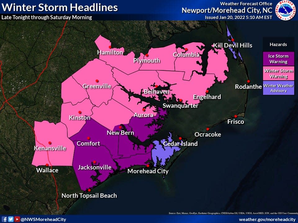
Thursday morning, an Ice Storm Warning in Onslow and Jones Counties and a Winter Storm Warning in Duplin County were issued for late Thursday night through Saturday morning as most of Eastern North Carolina will be under some form of winter weather warning or advisory heading into the weekend.
Ice could be an issue for Onslow area
Jacksonville and Onslow could see 0.25 inches to 0.5 inches of ice accumulation, according to NWS Morehead City, as parts of Duplin and Jones counties could see up to two inches of snow and sleet.
Less than an inch of snow and sleet could impact inland Onslow; however, freezing rain may be an issue. The weather service forecasts “extreme” ice and “very dangerous to nearly impossible travel” with power outages expected for its service area.
Although precipitation may begin earlier, the winter storm’s impacts in Onslow should start in the early morning hours of Friday from 2 a.m. to 5 a.m., and impacts could last throughout the weekend into Monday morning with risks of black ice and power outages amid low temperatures, the NWS said in its Thursday morning briefing.
In Jacksonville on Saturday, NWS forecasters are calling for a high of 34 and a nighttime low of 20. On Sunday, melting is expected to begin as temperatures reach the mid-40s in Jacksonville; however, Sunday night, they will dip back down into the low 20s, according to the NWS, which said max wind gusts in the 20s could mean an extra risk of potential tree and power issues.
Ryan Ellis, Science and Operations Officer at NWS Morehead City, said on Wednesday that inland Onslow and other inland areas could see the biggest impacts.
“Certainly on the eastern side of the county over by Swansboro you are a little closer to the warmer temperatures, so the most uncertainty is probably on that side of the county," Ellis said. "Inland [we have] more confidence that there's going to be potential significant impacts from the ice specifically.”
Onslow County Schools closed Friday
Onslow County Schools will be fully closed for all students and staff on Friday with no remote instruction, and all athletic and extracurricular events are canceled.
For the most up to date information, follow the National Weather Service on social media or visit www.weather.gov/mhx.
For the Pender County forecast, visit www.weather.gov/ilm.
Reporter Calvin Shomaker can be reached at cshomaker@gannett.com.
This article originally appeared on The Daily News: Ice accumulation possible in Onslow NC area starting Thursday night

