Ice, snow, and frigid thunder: How Ontario saw it all on Wednesday
Ontario hit bingo on Wednesday when the province experienced just about every autumnal weather condition possible over the course of a single day.
A potent system tracking across the Great Lakes brought the region a cascade of freezing rain, ice pellets, heavy rainfall, and even a bout of vivid thunderstorms that wouldn’t have felt out of place in July.
PHOTOS: Ice coats the roads in parts of Ontario as wintry mix hits
The active midweek weather that sent the atmosphere into upheaval over Ontario arrived courtesy of two systems—an Alberta clipper pushing in from the Prairies, and a Colorado low moseying in from south of the border.
Icy wonderland this morning. Some of it looks nice. Part of the yard looks like a rink. Fair amount of coating. When I was warming up the car, I felt like I was making an ice sculpture with how much chiselIing I did on my windshield. Thick stuff.
Icy wonderland this morning. Some of it looks nice. Part of the yard looks like a rink. Fair amount of coating. When I was warming up the car, I felt like I was making an ice sculpture with how much chiselIing I did on my windshield. Thick stuff. Nathan Howes TWN on Twitter: "Icy wonderland this morning. Some of it looks nice. Part of the yard looks like a rink. Fair amount of coating. When I was warming up the car, I felt like I was making an ice sculpture with how much chiselIing I did on my windshield. Thick stuff. #ONstorm #ONwx pic.twitter.com/Gs87CC7S0F / Twitter" Nathan Howes TWN on Twitter: "Icy wonderland this morning. Some of it looks nice. Part of the yard looks like a rink. Fair amount of coating. When I was warming up the car, I felt like I was making an ice sculpture with how much chiselIing I did on my windshield. Thick stuff. #ONstorm #ONwx pic.twitter.com/Gs87CC7S0F / Twitter" Nathan Howes TWN on Twitter: "Icy wonderland this morning. Some of it looks nice. Part of the yard looks like a rink. Fair amount of coating. When I was warming up the car, I felt like I was making an ice sculpture with how much chiselIing I did on my windshield. Thick stuff. #ONstorm #ONwx pic.twitter.com/Gs87CC7S0F / Twitter"
Warmer air over southwestern Ontario kept the system mostly rain, while folks around and north of cottage country dealt with plain ol’ snow.
However, that collision of air masses led to a more complicated dynamic over southern and eastern sections of the province. Warmer winds from the south blew up and over cold, dense air hugging the surface.
This temperature inversion was a classic setup for both ice pellets and freezing rain, the latter of which brought a significant crust of ice to trees, power lines, and roads across the region.
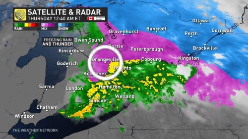
The same setup that brought icy conditions to the region also played a vital role in the widespread thunderstorms that swept over parts of the Golden Horseshoe late Wednesday evening.
As the core of the system arrived on Wednesday night, we saw temperatures hovering around or just above freezing at the surface even as air temperatures just a few hundred metres above the ground registered at a relatively balmy 10°C.
Caught this great CG lightning strike on camera in the west end of Kitchener! #ONStorm #ONwx pic.twitter.com/7ablgCo4pk
Caught this great CG lightning strike on camera in the west end of Kitchener! WeatherCAN on Twitter: "Caught this great CG lightning strike on camera in the west end of Kitchener! #ONStorm #ONwx pic.twitter.com/7ablgCo4pk / Twitter" WeatherCAN on Twitter: "Caught this great CG lightning strike on camera in the west end of Kitchener! #ONStorm #ONwx pic.twitter.com/7ablgCo4pk / Twitter" WeatherCAN on Twitter: "Caught this great CG lightning strike on camera in the west end of Kitchener! #ONStorm #ONwx pic.twitter.com/7ablgCo4pk / Twitter"
— WeatherCAN (@1Weathercanada) WeatherCAN on Twitter: "Caught this great CG lightning strike on camera in the west end of Kitchener! #ONStorm #ONwx pic.twitter.com/7ablgCo4pk / Twitter"
This warmer air aloft led to a phenomenon known as elevated convection. Most thunderstorms form as unstable air rises from the surface. During certain situations—like the one we saw in southern Ontario on Wednesday night—air rises from that pocket of warmer air aloft instead.
DON'T MISS: Slippery as ice: Brightly-coloured leaves mask dangerous threat
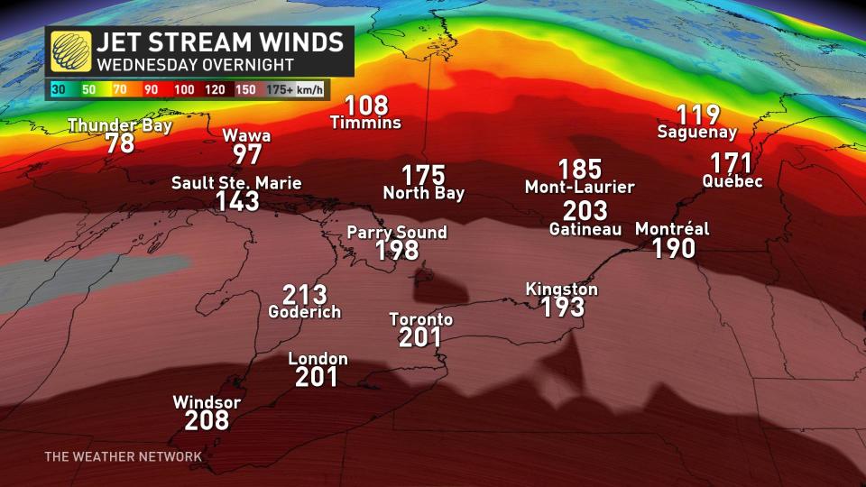
A powerful jet stream high in the atmosphere helped generate even more lift, giving that rising air the extra boost it needed to trigger honest-to-goodness thunderstorms across southern Ontario.
We saw dozens of lightning strikes around the western half of Lake Ontario during the late evening hours. While most communities around and south of the Greater Toronto Area saw all rain, folks just to the north and west witnessed thunder and lightning during freezing rain.
The temperature inversion even acted like a ‘cap’ on the atmosphere that forced thunder to stay close to the ground, travelling long distances while it echoed loudly through the chilly night air.
Header image courtesy of Anika Beaudry in St. Catharines, Ontario, on Wednesday evening.

