Icy, snowy winter storm to blast the Northeast early this week
A multifaceted winter storm is expected to overspread the Northeast during the first half of the week, bringing traffic-snarling snow, wind and ice to the region.
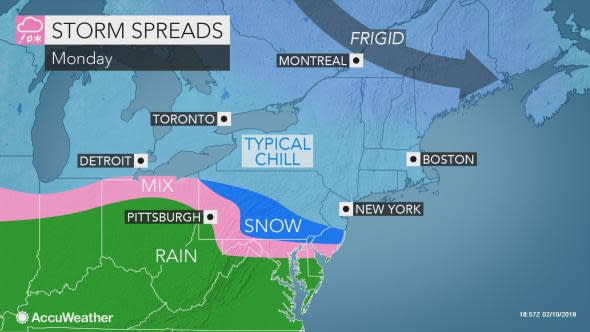
Some snow and ice moved through the mid-Atlantic on Sunday night ahead of the main storm. However, even more disruptive winter weather is expected to unfold into Tuesday.
The storm will start as freezing rain across a swath of the Ohio Valley and snow in the mid-Atlantic around Philadelphia and State College, Pennsylvania.
On Monday night, snow will overspread much of New York, Pennsylvania and New Jersey while icy conditions plague a swath stretching from central Michigan to the Delmarva, including Detroit, Harrisburg, Baltimore and Philadelphia.
During this time, travel will become increasingly difficult and dangerous as roads become coated in slick snow and ice. Widespread instances of spin-outs and accidents can occur, as well as mounting airline delays.
Snow will continue over much of New York and New England on Tuesday while freezing rain and sleet fall across southern New York, eastern Pennsylvania and New Jersey. Any snow that hasn't been cleared away will become heavier and harder to remove with the added ice.
Even plowed roads can become ice-covered, refreshing dangerous driving conditions from Syracuse to New York City.
"Parts of Pennsylvania could receive 3-6 inches of snow Monday afternoon through Monday night before a change to ice," according to AccuWeather Senior Meteorologist Mike Doll.
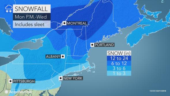
"Snowfall of 6-12 inches will be common from northern New York state to southeastern Maine," according to AccuWeather Senior Meteorologist Alex Sosnowski.
"However, from 12-18 inches of snow is forecast over the northern tier of New England," Sosnowski said.
As this storm unfolds over the Northeast, travel can become impossible for a time.
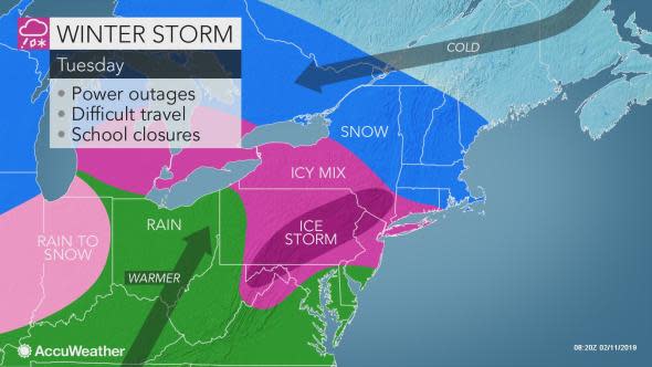
"A significant buildup of ice, on the order of 0.25 to 0.50 of an inch is likely from the eastern Panhandle of West Virginia and Maryland to central New York state and southern New Hampshire with this storm," Sosnowski said.
Where this buildup is mostly freezing rain and not sleet, trees and power lines will be weighed down to the point of causing at least sporadic power outages.
"While an AccuWeather Local StormMax™ of 0.60 of an inch of freezing rain can occur, in some areas, the combination of sleet and freezing rain may cause an ice buildup close to an inch or more, on top of the snow that falls in some locations," Sosnowski said.
Travel will be difficult, if not dangerous for a time due to the icy conditions.
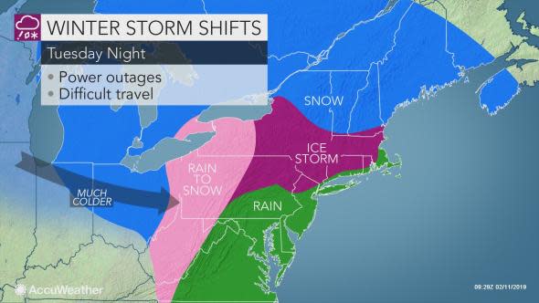
Farther south, heavy rain will move in to replace icy conditions as milder air inches up the East Coast. Residents of the Ohio Valley and much of the mid-Atlantic, including western Pennsylvania, Maryland the the Delmarva, can expect rain and melting ice and snow to pond on roads and saturate lawns on Tuesday.
Travel delays can arise due to localized flooding, gusty winds and limited visibility.
As the storm moves away on Tuesday night, a changeover to rain is expected along the Interstate 95 corridor from Washington, D.C. to Boston. Farther inland, a cooldown will lead to another round of wintry precipitation.
This means that despite drier weather on Wednesday, roads and sidewalks can still be slick as temperatures fall.
Download the free AccuWeather app to stay up-to-date on your local forecast, warnings and advisories. Plan ahead now to avoid travel during wintry conditions.
"If anyone has to be out during the storm, it is advisable to heed all travel restrictions and guidelines on area roads," Doll said.