Icy storms could spark more power outages across storm-weary West Coast

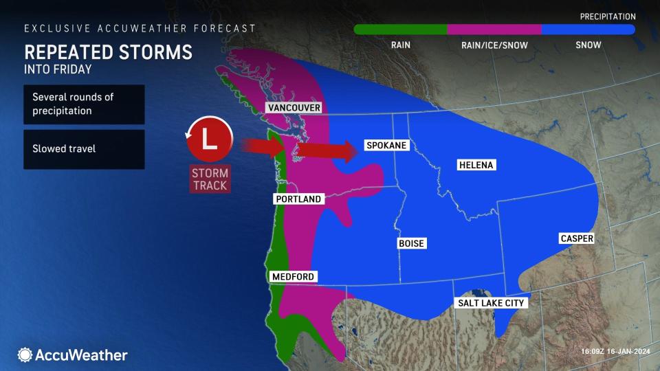

After a brief reprieve of the wintry weather to start the week, the pattern across the West is about to ramp up. AccuWeather meteorologists say that a storm that tracked onshore on Tuesday can bring another round of coastal rain, a corridor of ice and even mountain snow to the region. Later in the week and into next week, additional systems can trudge into the West Coast and make for a wet and wintry stretch.
The first storm on deck early this week will push into parts of Washington, Oregon, Northern California and Utah into Wednesday. Locations closer to the coast from Astoria, Oregon, to Eureka, California, will have daytime highs in the upper 40s and 50s on Wednesday, resulting in rounds of rain.
 |
At times, the rain that propels into the Pacific Northwest into midweek can become heavy, leading to localized flooding and transportation delays along areas of routes 12, 20, 26, 30, 101 and 199 and nearby roadways closer to the coast.
Following the storm that moved through the Northwest over the weekend, over 70,000 customers were still experiencing outages throughout northwest Oregon as of the overnight hours Tuesday night, according to PowerOutage.us. Reports state that crews have been working diligently to restore power since Saturday.
However, in those areas where power was not restored before the latest storm arrived, power companies could face additional challenges working outdoors under the stormy conditions, with additional outages now tallying up once again.
Snowfall accumulations are expected to pick up in the mountains of Washington, Oregon and into portions of the northern Rockies as snow levels rise to 1,500 to 2,500 feet for Wednesday. Amounts across the lower levels of the Cascades can range up to a foot by Wednesday and up to 2 to 3 feet in the highest peaks.
The rain will let up to the south in southwestern Oregon and Northern California late Wednesday. However, another storm can track into the region by the end of the week and usher in cycles of moisture and steady rain.
 |
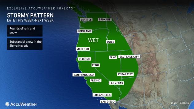
"Later this week, a noticeable shift in the pattern will arrive for parts of California. Multiple waves of storms will advance into the region, spreading rounds of rainfall across areas of central and northern California between Friday and early next week," explained AccuWeather Meteorologist Elizabeth Danco.
Forecasters say that snow will fall across the higher terrain, including the Sierra Nevada, the mountain ranges across Nevada, and into parts of the Rocky Mountains. Into the weekend, the highest snowfall accumulations are expected to occur upwards of 8,000-9,000 feet.
Want next-level safety, ad-free? Unlock advanced, hyperlocal severe weather alerts when you subscribe to Premium+ on the AccuWeather app. AccuWeather Alerts™ are prompted by our expert meteorologists who monitor and analyze dangerous weather risks 24/7 to keep you and your family safer.
