Idalia expected to be a Cat 3 hurricane at landfall. How much rain will MS Coast get?
- Oops!Something went wrong.Please try again later.
South Mississippi is likely to see some impacts from the outer bands of Tropical Storm Idalia as the storm’s path tracks toward Florida’s west coast.
The Gulfport-Biloxi metro awoke to thunder and rain Monday and temperatures are forecast to be in the low to mid-90s this week, rather than the high 90s and over 100 experienced during much of August.
Rain is also forecast to continue all week after South Mississippi saw little rainfall during the past month and is in drought conditions.
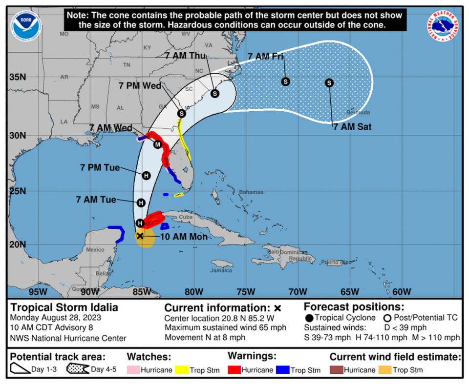
At the 10 p.m. CDT update Monday, the National Hurricane Center says Idalia could become a hurricane at any time and is expected to become a powerful hurricane over the eastern Gulf of Mexico.
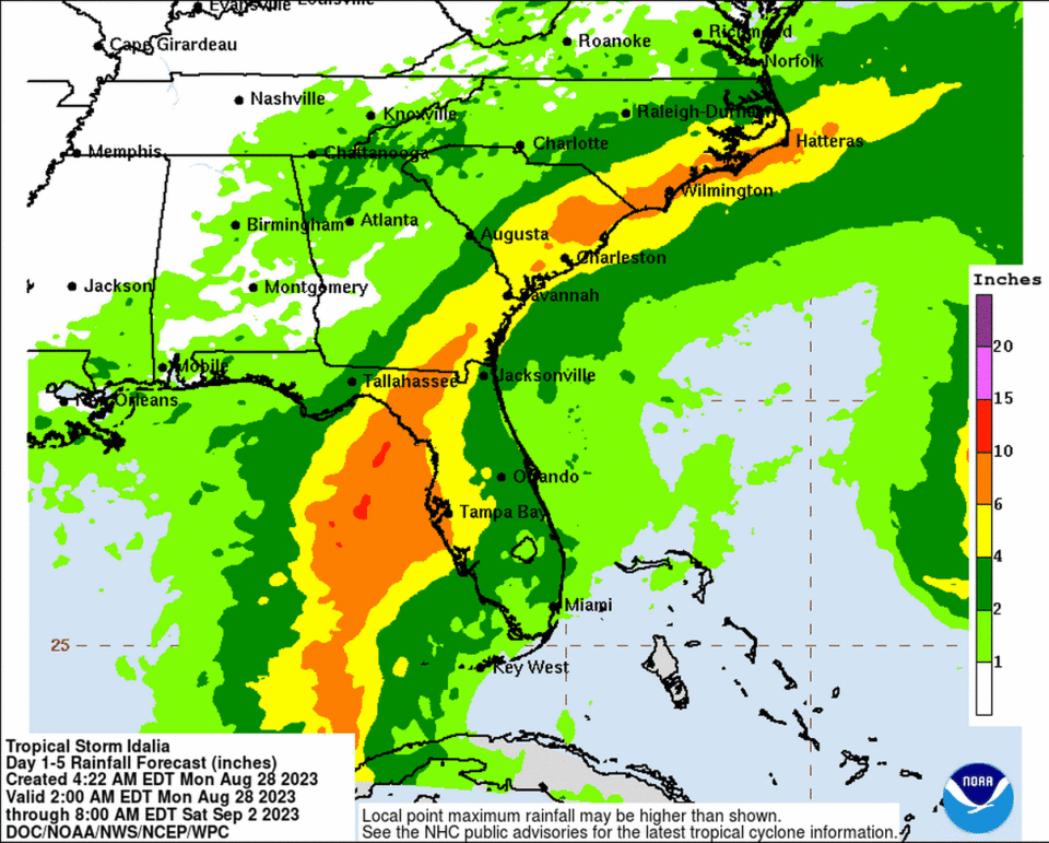
The Mississippi Gulf Coast could get 1-2 inches of rain from the hurricane, with some areas seeing 2-4 inches. Winds from Idalia aren’t forecast to reach South Mississippi.
As with Hurricane Ian last year, the track of Tropical Storm Idalia continues to change. On its current path, it is expected to become a hurricane when it nears western Cuba on Monday.
The latest forecast puts landfall on the west coast of Florida, between Tampa Bay and the Florida Panhandle Wednesday as a major Category 3 hurricane.
Storm surge and hurricane warnings are issued for portions of the west coast of Florida, and the National Hurricane Center advises: “Life-threatening storm surge and dangerous winds are becoming increasingly likely for portions of Florida.”
Two major hurricanes brewing in Atlantic Basin
The Air Force Reserve Hurricane Hunters, based in Biloxi, are flying into Idalia and Hurricane Franklin, which is expected to rapidly intensifies into a category 4 hurricane.
Franklin is bringing life-threatening surf and rip currents along the coast of the Southeast U.S. as Labor Day Weekend approaches, and a tropical storm watch is up for Bermuda, as the forecast track is for the hurricane to pass to the north.
This could be the first time since 2017 two major hurricane systems are in the Atlantic basin, says Jim Cantore, meteorologist with the Weather Channel.
Morning Viz of Cat4 MAJOR Hurricane Franklin. Its possible we have 2 majors at the same time in the basin. Last time that happened: Irma and Jose in September 2017 per @wxmattjones pic.twitter.com/M8gIsuSRzD
— Jim Cantore (@JimCantore) August 28, 2023
Idalia strengthened Monday as aimed at Florida.
“Areas of flash and urban flooding, some of which may be locally significant, are expected across portions of the west coast of Florida, the Florida Panhandle and southern Georgia Tuesday into Wednesday, spreading into portions of the eastern Carolinas (NC & SC) Wednesday into Thursday,” the NHC advisory said.
Weather forecast for South Mississippi
After enduring an extremely hot and dry August, the final few days will bring a mixed bag of weather to South Mississippi.
Patchy smoke from the Louisiana wildfires is drifting east into Mississippi, producing a moderate air quality.
The forecast from the National Weather Service in New Orleans shows a chance of showers and thunderstorms all week in Gulfport and across the Coast:
▪ Monday — Showers and thunderstorms, mainly after 4p.m. Chance of precipitation 80%. High near 94.
▪ Tuesday — Showers likely, then thunderstorms, 80% chance of precipitation. High near 91
▪ Wednesday — 40% chance of thunderstorms. High near 93
▪ Thursday — 40% chance of showers and thunderstorms. High near 92
▪ Friday — Chance of showers and thunderstorms. High near 91
▪ Saturday — Chance of showers and thunderstorms. High near 90
South Mississippi is in a severe drought, according to the drought monitor, and a moderate drought in southeastern Jackson County.

