Idalia forecast: Florida faces a major hurricane threat; prepare now | WeatherTiger
- Oops!Something went wrong.Please try again later.
The number one rule of this column is not to pull the fire alarm unless there is a fire.
Idalia is a fire. I’m pulling the alarm.
More damaging and less damaging outcomes remain on the table, but the eastern Panhandle, Big Bend, and west-central Florida coasts are at serious risk of surge, wind, and rain impacts from a potential major hurricane landfall Wednesday. Preparations to secure life and property should start now in these areas.
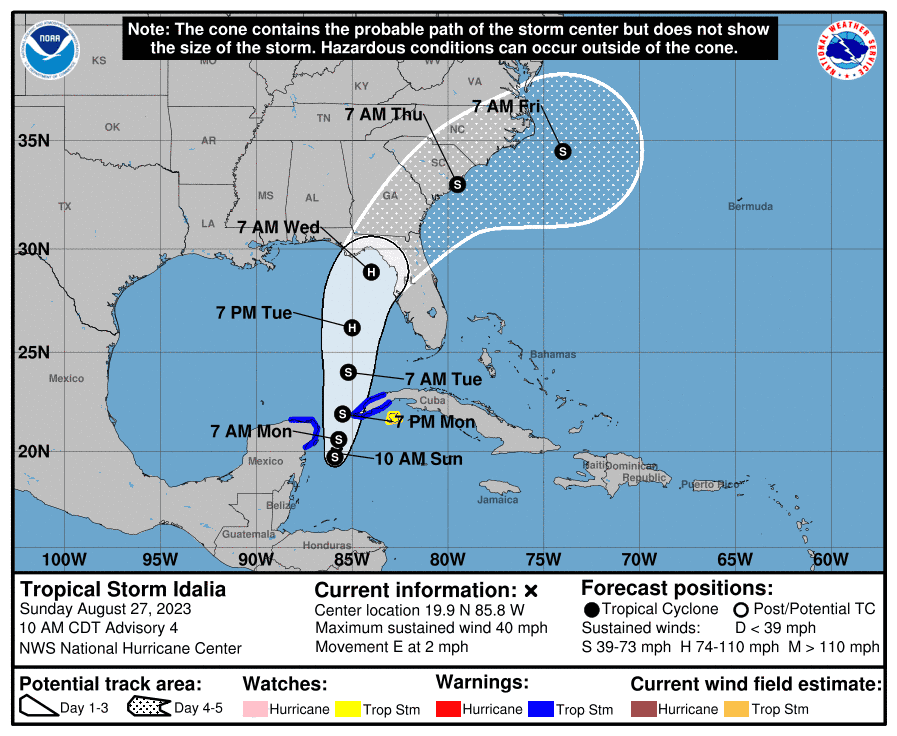
As of mid-day Sunday, Idalia is located in the far northwestern Caribbean Sea, about 50 miles offshore the Yucatan peninsula. Maximum sustained winds have increased to 40 mph. Meandering movement is expected through early Monday, at which point Idalia will begin to edge north into the Gulf of Mexico. Slow but steady intensification is likely through the day on Monday, and Idalia will likely be at or nearing hurricane intensity by early Tuesday.
Several key developments over the weekend have increased the severity of the Florida threat. Most critically, Idalia has organized more quickly than models and forecasters anticipated, becoming a tropical depression on Saturday rather than the Sunday or Monday timeframe that seemed more probable last week.
Idalia’s circulation also developed over water rather than partially or fully over the Yucatan peninsula, which would have delayed strengthening until it entered the Gulf.
Instead, Idalia gets the weekend to assemble a core of deep convection near its center, setting it up for potential rapid intensification on approach to Florida. While Idalia reaching major hurricane intensity is not certain, the warning signals are there and we’d be naïve to ignore them.
Here’s the general roadmap of track and intensity expectations over the days ahead.
Track forecast: A likely path emerges
Unlike Ian, Idalia’s track forecast is not overly uncertain or complicated. With a unified center of circulation developing further east and south than anticipated, Idalia is not going to track towards the western Panhandle or central Gulf Coast. Idalia’s early formation has also unfortunately eliminated the potential for a weak, disorganized storm to be swept northeast across south-central or southern Florida.
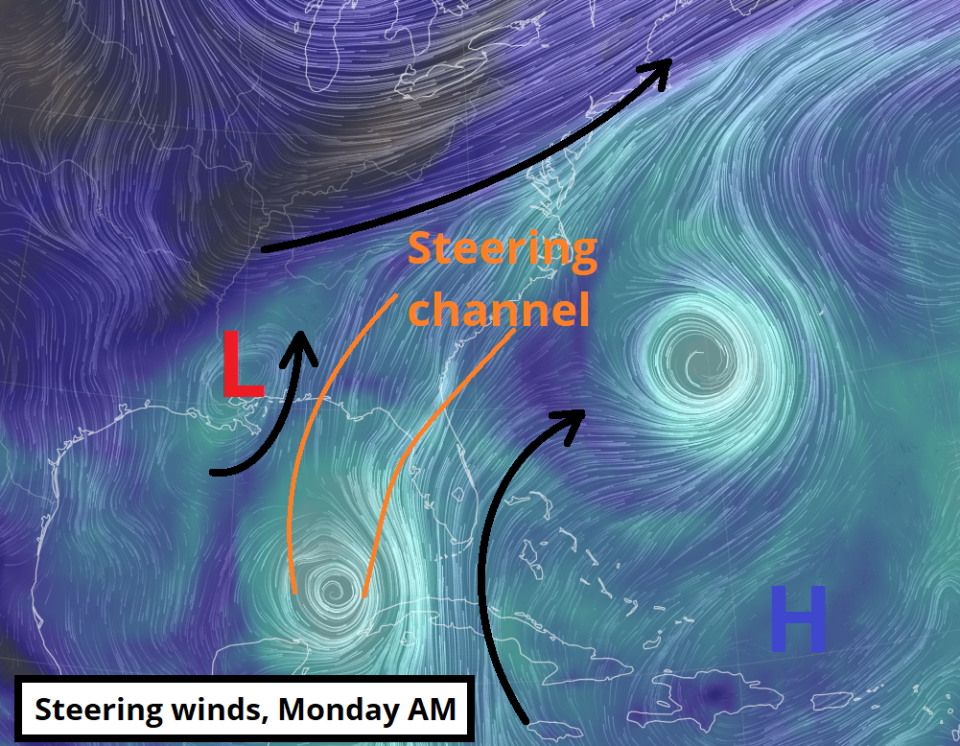
Instead, Idalia will follow a relatively narrow channel of north and north-northeastward steering currents between an upper low over the western Gulf, a deep trough over the Great Lakes, and subtropical ridging over the southwestern Atlantic. These currents will accelerate Idalia north on Monday, then north-northeastward late Tuesday and early Wednesday.
This path will intercept the north Florida coastline by mid-day Wednesday. Panama City to the northern Tampa Bay region is the broad range of potential landfall locations, but the heart of the Cantore Zone is eastern Apalachicola Bay east to Crystal River, or the section of Florida coastline south and west of Tallahassee to Gainesville. Idalia should accelerate northeast post-landfall in the general direction of Jacksonville.
Agreement on this track is strong, with little difference between the average tracks of the various models’ ensemble averages. The details are to be determined, but I am confident that Idalia is coming to the eastern Panhandle, Big Bend, or upper Nature Coast.
Intensity forecast: Rapid intensification risks and the hope of dry air
The real uncertainty with Idalia is whether it will be a hurricane or a major hurricane on approach to North Florida. Currently, Idalia is asymmetrical due to some northerly wind shear, with most storm activity displaced south and east of the center. Some drier air two to three miles up in the atmosphere is also lurking north of the storm.
▶Storm Tracker and Model mixer: Our interactive map updated with the latest model runs
Exactly how this dry airmass interacts with Idalia will be critical in determining how strong a hurricane Florida is dealing with.
The models are split on to what extent this drier air will overspread the western half of Idalia on Monday and early Tuesday, with those that have more of it keeping Idalia’s intensification rate in check. Idalia is going to strengthen through early Tuesday, but it is an open question of whether it’s still a tropical storm at that point, or already a Category 1 or 2 hurricane.
Tuesday is a dangerous day, and I don’t like what I’m seeing.
As Idalia lifts north into the east-central Gulf, the upper-level winds north of the storm will begin to ventilate thunderstorm activity as well, while healthy outflow continues to its south. This is called “dual-channel outflow,” and it’s a really worrisome thing to see as it tends to be a key marker highlighting the potential for rapid intensification— a jump in maximum sustained winds of 35 mph or more in 24 hours.
This very favorable upper-level wind environment on Tuesday will coincide with Idalia crossing a region of extreme, record-breaking water temperatures in the northeastern Gulf of Mexico. Surface temperatures are mostly in the upper 80s, and even worse, extend deep below the surface as well.
Shades of Hurricane Michael? A 50-50 chance of major hurricane landfall
I know the Hurricane Michael comparison is in the minds of many with Idalia, and for good reason. Tuesday’s dual-channel outflow and favorable jet stream interaction is analogous to what Michael experienced on its approach. Unfortunately, the northeast Gulf waters are even warmer and deeper than what Michael had to work with. Which was plenty.
For these reasons, I am very concerned about the potential for Idalia to undergo a rapid intensification cycle on Tuesday or early Wednesday on approach to Florida.
Now, rapid intensification is finicky and impossible to predict precisely. It’s not certain to happen, and if more dry air overspreads Idalia in the next 36 to 48 hours, that could tap the brakes on the process.
But Floridians need to be aware that many of the warning signs of rapid intensification into landfall are there. If I had to lay odds on it, as of mid-day Sunday there is a 50-50 chance of major hurricane landfall on Wednesday.
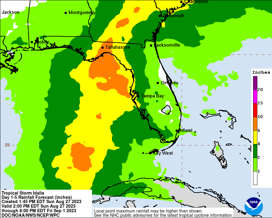
That means time to prepare is short, with bad weather likely arriving along the Gulf Coast on Tuesday. The storm is likely to spread major surge impacts in the Big Bend and peninsular Gulf Coast even under less bad outcomes, including well south and east of the probable landfall point, like Tampa Bay.
I’ll have much more tomorrow on the expected surge, wind, and rain impacts of Idalia, but you need to start preparing now in the Panhandle, north-central Florida, and west-central Florida. Idalia will come at you faster than you think, and unless you go into hurricane mode now, you’re not going to be ready. Get ready.
I don’t want to pull the fire alarm, but Idalia has infernal potential, and you need to react now while you still have time. Stay safe, Florida, and keep watching the skies.

Dr. Ryan Truchelut is chief meteorologist at WeatherTiger, a Tallahassee start-up providing forensic meteorology and expert witness consulting services, and agricultural and hurricane forecasting subscriptions. Get in touch at ryan@weathertiger.com, and visit weathertiger.com for an enhanced, real-time version of our seasonal outlook.
This article originally appeared on Tallahassee Democrat: Tropical Storm Idalia a major hurricane threat to Florida | Forecast

