Idalia: Hurricane will bring catastrophic surge to Florida coast | Forecast
Why is it always Wednesday?
There’s no answer beyond coincidence for why Florida’s four most recent hurricanes — Michael, Sally, Ian, and Nicole — have all struck on the same cursed day of the week.
Idalia remains on a collision course with the Florida Gulf Coast.
Track expectations have changed little since yesterday, and landfall is most likely in eastern Apalachee Bay or the northern Nature Coast by mid-day Wednesday. Idalia will likely bring catastrophic surge to a broad swath of the west-central Florida and Big Bend coastline, and a core of destructive winds to an unlucky but still unknown swath of North Florida.
Tracking Idalia
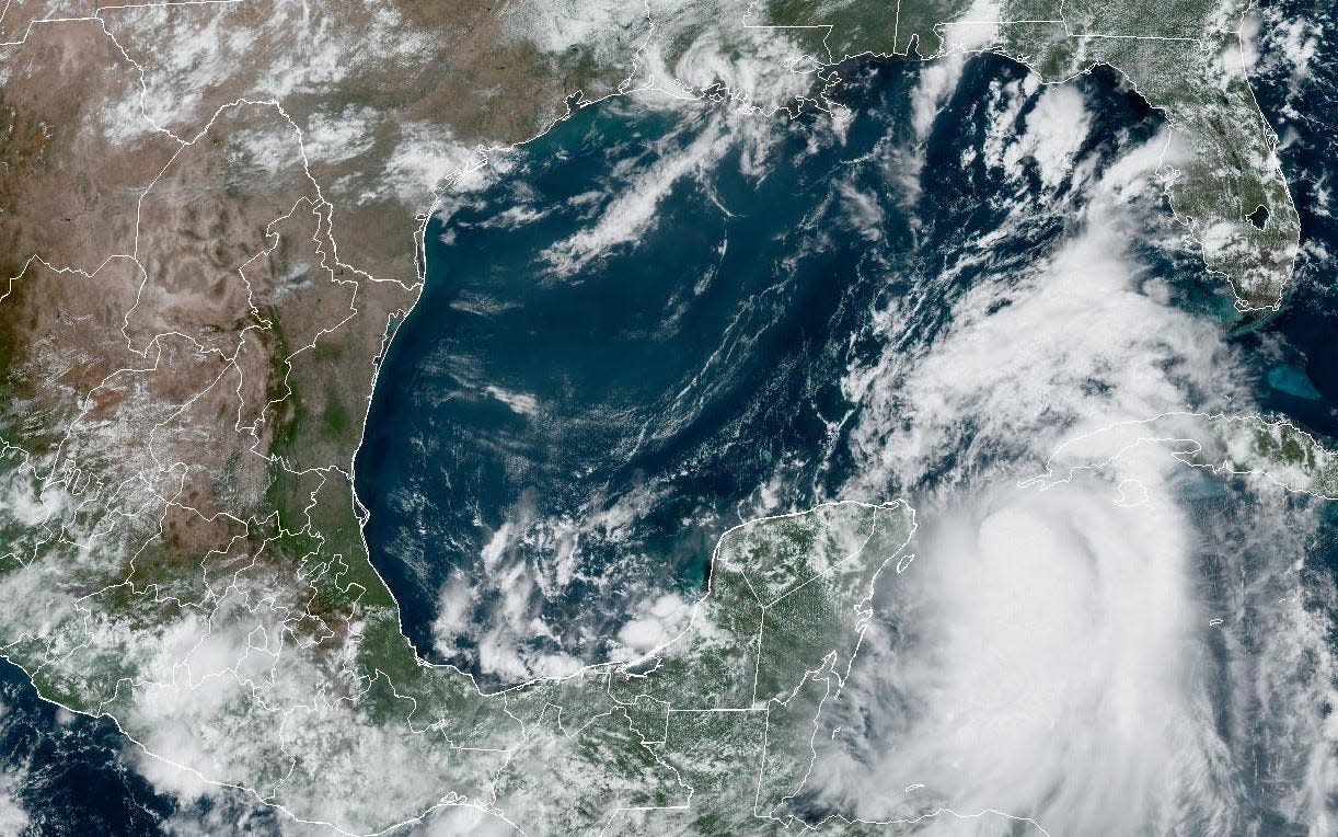
As of mid-day Monday, the center of Idalia has begun its trek north toward the Gulf of Mexico, and is located about 500 miles south of Tampa, moving due north at about 8 mph. Idalia’s movement as tracked by Hurricane Hunter aircraft and Cuban and Mexican radar has closely followed the NHC forecast track. Most model guidance over the past 12-24 hours, and the official track forecast is little changed since Sunday afternoon.
Hurricane and Storm Surge Warnings are now in effect.
Maximum sustained winds are 65 mph per the NHC 11 a.m. Monday advisory, with the storm remaining somewhat lopsided for the moment due to drier air and limited outflow in the northern half of the storm. Reconnaissance observations and guidance suggest these factors will keep Idalia’s rate of strengthening in check through early Tuesday.
Rapid intensification coming and a Cat-4 hurricane is possible
Unfortunately, conditions remain prime for rapid intensification starting Tuesday morning. Dry air is expected to have mixed out of Idalia’s core by that time, and the incredible heat energy of the eastern Gulf at the surface teams twin outflow jets aloft are likely to trigger a scary increase in intensity into early Wednesday.
It’s impossible to peg how high this potential rapid intensification cycle will go. As of Monday, the NHC is now predicting a Category 3 hurricane in the eastern Gulf, and a peak at Category 4 is certainly a possibility.
The track forecast continues to be tightly focused on a path toward the eastern Panhandle and northern Nature Coast. With Idalia now embedded in a narrow channel of steering winds between high pressure to the west and a dip in the jet stream to its north, we are not likely to see huge leaps in the projected path.
The most probable landfall range is between Alligator Point and Crystal River, likely Wednesday morning. As always, minor adjustments in the forecast track are likely over the next 36 hours, but don’t bank on an eleventh-hour reprieve if you are in the projected path of Idalia.
The anticipated landfall on Wednesday is a dangerous and extremely rare scenario for north-central and west-central Florida. While the Big Bend and Nature Coast are no stranger to hurricanes, should Idalia make landfall there as a major hurricane, it would be just the second Category 3 or higher to strike to do so in the last 170 years.
As the only other major hurricane in that section of coast hit in 1896, there are a lot of communities that are going to be tested by all four hurricane hazards — surge, wind, rain, and tornadoes — with no modern reference point for such an event.
Let’s go one-by-one through each of those hazards to get a full picture of the threat Idalia poses to Florida.
A storm surge event unlike any other with catastrophic coastal flooding
Water is the true killer in a hurricane, and there is no hazard more deadly or destructive in a hurricane than storm surge. No matter the precise track, Idalia will be a surge event unlike any hurricane in the modern era for west-central Florida. The powerful windfield of Idalia’s eastern half will push a wall of water north onto the shallow Gulf continental shelf that last-minute changes in maximum winds or track can’t alter. Additionally, an untimely supermoon on Wednesday will further enhance tides and coastal flooding potential.
As such, Storm Surge Warnings are in place for much of Florida’s Gulf Coast, now extending from central Apalachee Bay to just north of Charlotte Harbor, including Tampa Bay. NHC modeling is currently calling for peak surge of 7-11’ from eastern Apalachee Bay and along the Nature Coast.
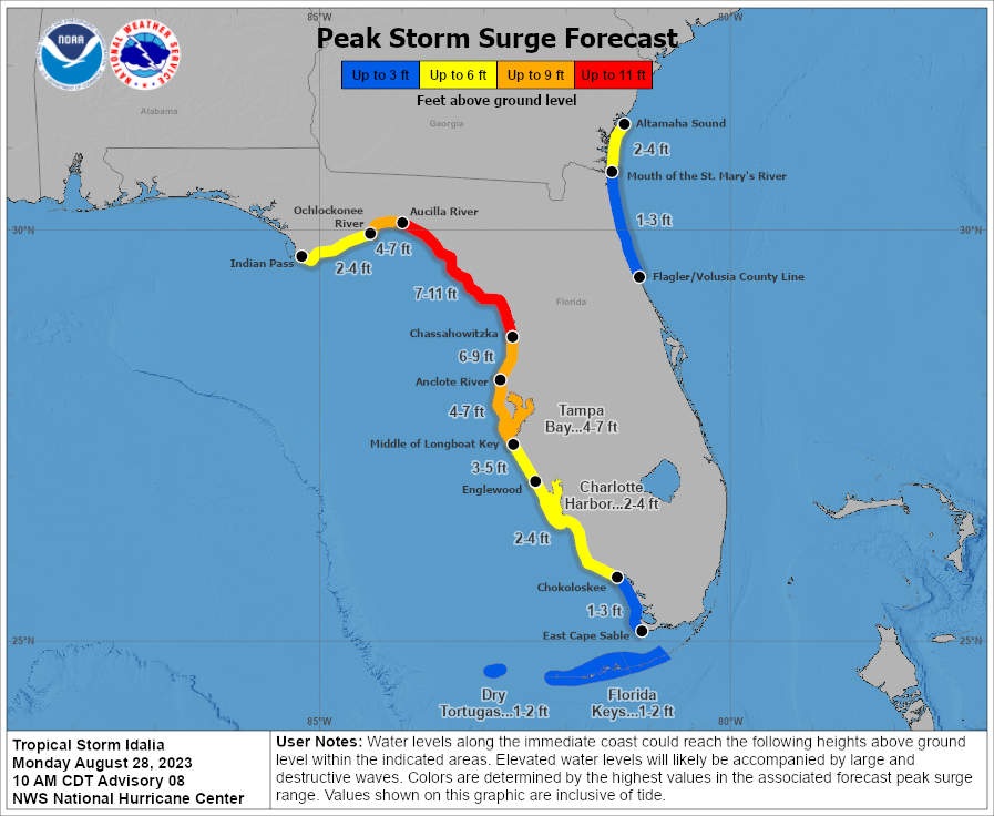
For Apalachee Bay, 7-11’ of surge is a potential value; if Idalia’s center tracks south and east of the Bay, actual surge will be lower than in the very possible outcome of Idalia tracking through the Bay. We won’t know what will happen until closer to landfall, so hope for the best but prepare for the worst.
For the Nature Coast, this surge is life-threatening, without living precedent, and very likely to happen. Whether Idalia makes landfall in the Nature Coast or passes just to your north and west, strong, onshore winds out of the southeast driving catastrophic coastal flooding are virtually certain to a greater or lesser extent.
If you are told to evacuate, leave. You can hide from the wind, but you need to run from water.
This applies to Tampa Bay as well, where the current NHC projection is 4-7’ of surge. While Idalia will not make landfall in Tampa, a track west of the metro area means south and southeast winds will push water into the bay, rather than out of it as in Irma and Ian.
Know your evacuation zone, have a way of receiving emergency information, and react if you get an evacuation order. Even moving just a few miles inland can keep you out of harm’s way.
Southwest Florida, though well away from the storm itself, is also likely to see 2-4’ of surge above normal high tides. This area is under a Storm Surge Watch as of mid-day Monday.
Winds: A truly ferocious punch is coming, but the target isn't clear
Wind is the hardest hurricane threat to pin down. While damaging, tropical-storm-force gusts capable of knocking out power and damaging trees will occur over a wide region extending from the Central Panhandle to Central Florida to coastal Southwest Florida, Idalia’s truly destructive winds, are likely to occur over a much more limited area area near the center of circulation.
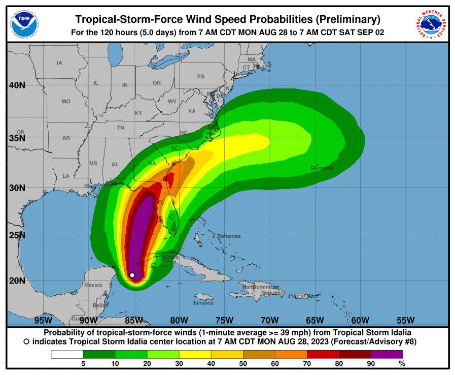
For this reason, it’s too soon to put a fine point on local wind expectations, not for the least of reasons that maximum winds can ramp up or down quickly.
In the eastern Panhandle, including Tallahassee, we simply don’t know at this point whether Idalia will pass far enough south and east of us such that hurricane-force winds will miss us, or whether we will get a portion of Idalia’s core.
Both are possible.
What can be said at this point is the highest chances of wind gusts exceeding 100 mph are focused on the west-central Florida and eastern Apalachee Bay coastlines. The highest chances of hurricane-force wind gusts inland are roughly between Gainesville, Tallahassee, and coastal Georgia. This could change.
Rainfall: A very real but secondary threat
When people think of hurricane threats, excessive rainfall and flooding isn’t necessarily the first thing that comes to mind. But it should be — nearly one-third of tropical cyclone-related casualties are caused by freshwater flooding.
With Idalia likely accelerating by landfall to a forward speed of a brisk 15-20 mph, heavy rainfall will be a secondary impact of the storm. Periodic rain bands will overspread the southern half of Florida through mid-day Tuesday, and the remainder of the state by Tuesday night.
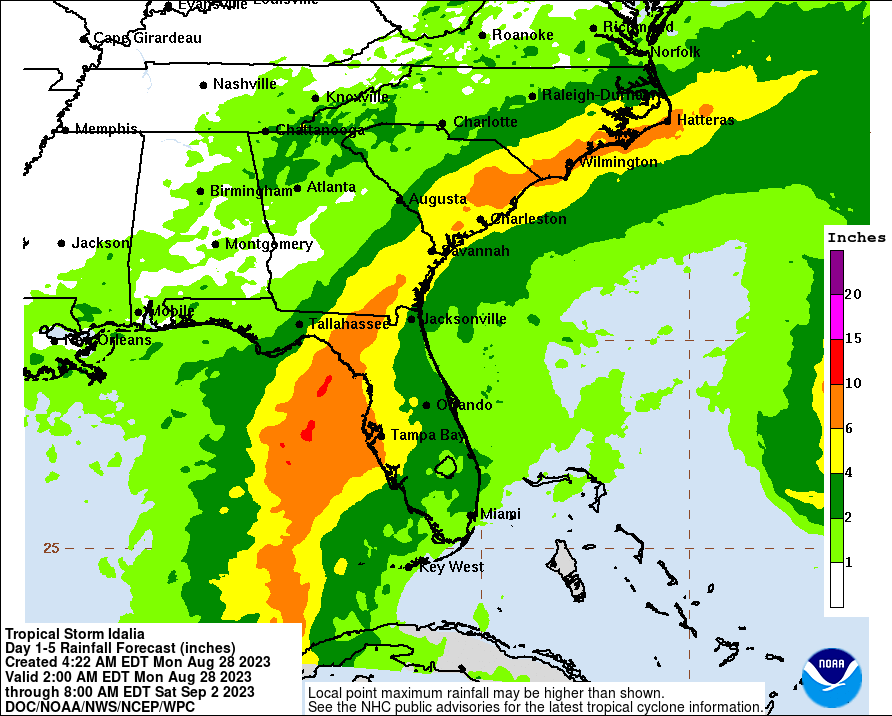
Look for rains to be heaviest and most persistent through mid-day Wednesday in the eastern Panhandle, northeast Florida, and west-central Florida, where storm totals of 4-8” are likely and localized flash flooding is possible. Otherwise, accumulations across the state will be 1-4”, with a sharp cutoff in Idalia’s rains and much lower totals in the western Panhandle.
Tornadoes: A hurricane's deadly spawn
Tornadic activity is common in landfalling hurricanes, mostly in bands north and east of the circulation center. Occasional tornadic cells within outer bands are most likely on Tuesday in west-central Florida, with some chance of short-lived tornadoes across the rest of the peninsula as well. Tornado risks will spread north and focus on northeast Florida on Wednesday.
It’s hard to find much of a cause for optimism as yet another Wednesday’s child, full of woe, bears down on Florida.
Idalia is a four-quadrant threat that will combine widespread life-threatening and damaging surge with more locally destructive wind impacts. These projected impacts may shift prior to landfall, and everyone in Southwest Florida, Central Florida, North Florida, and the eastern Panhandle should be closely monitoring the latest information from the National Hurricane Center, your National Weather Service office, and local emergency management.
I will be back tomorrow with a region-by-region threat breakdown ahead of the worst of the storm.
Good luck, Florida. We’ll need it. Keep watching the skies.

Dr. Ryan Truchelut is chief meteorologist at WeatherTiger, a Tallahassee start-up providing forensic meteorology and expert witness consulting services, and agricultural and hurricane forecasting subscriptions. Get in touch at ryan@weathertiger.com, and visit weathertiger.com for an enhanced, real-time version of our seasonal outlook.
This article originally appeared on Tallahassee Democrat: Idalia: A Florida hurricane threat of surge, rain, wind | Forecast

