Idalia pounding North Carolina. Tropical Storm Jose forms southeast of Hurricane Franklin
Idalia text message updates: Sign up to receive updates on Hurricane Idalia and its aftermath from journalists across the USA TODAY network
The Atlantic Ocean is getting a little crowded.
As Tropical Storm Idalia starts to lose steam after bringing heavy rainfall and life-threatening flooding to North Carolina this morning, a new tropical storm has popped up in the Atlantic, Jose.
Idalia left behind a trail of destruction after making landfall as a Category 3 hurricane near Keaton Beach Wednesday morning.
More than 24 hours later, Idalia is losing its tropical characteristics, although strong winds and storm surge are continuing along the coast of North Carolina.
Just to the east of Idalia is Hurricane Franklin, which is now moving away from Bermuda. Dangerous surf and rip currents associated with Franklin are being felt along the mid-Atlantic and northeastern United States.
WeatherTiger Hurricane recap: Idalia exits Florida, shows line between blessings, disaster
Tropical Storm Jose is located southeast of Franklin in the Central Atlantic. Jose is expected to be absorbed by Franklin by the weekend.
Also being tracked by the National Hurricane Center is a tropical wave — Invest 94L — off the coast of Africa that is expected to become a tropical depression soon and the remnants of Gert located west of Jose.
By 2 p.m., a new system appeared in the eastern Atlantic that currently has a low chance for development.
The next named storm of the season will be Katia.
Here's the latest update from the NHC as of 2 p.m.:
Tropical Storm Idalia

Location: 120 miles southeast of Cape Lookout, North Carolina
Maximum wind speed: 65 mph
Direction: east at 20 mph
On the forecast track, Idalia will move away from the coast of North Carolina today and tonight, and approach Bermuda over the weekend.
Maximum sustained winds have increased to near 65 mph, with higher gusts. Little change in strengthis expected through this evening. Some slight weakening is forecast tonight and on Friday.
Idalia is forecast to become a post-tropical cyclone later today, but it is expected to make a transition back to a tropical storm over the weekend.
Hurricane Idalia damage: See photos of Category 3 hurricane as it makes landfall in Florida
Spaghetti models for Tropical Storm Idalia
Hurricane Franklin

Location: 265 miles northeast of Bermuda
Maximum wind speed: 100 mph
Direction: east-northeast at 14 mph
Maximum sustained winds are near 100 mph, with higher gusts. Gradual weakening is expected over the next few days, and Franklin is forecast to become an extratropical cyclone by this weekend.
Hurricane-force winds extend outward up to 60 miles from the center and tropical-storm-force winds extend outward up to 175 miles.
Spaghetti models for Franklin
Tropical Storm Jose

Location: 770 miles east of Bermuda
Maximum sustained winds: 40 mph
Movement: north at 7 mph
Satellite wind data indicate that maximum sustained winds are near 40 mph, with higher gusts. Little change is strength is forecast during the next day or so, and Jose is expected to become absorbed by Franklin on Friday.
Tropical-storm-force winds extend outward up to 45 miles from the center.
Spaghetti models for Tropical Storm Jose
What else is out there and how likely are they to strengthen?

Invest 94L: An area of low pressure located just west of the Cabo Verde Islands continues to produce showers and thunderstorms with some signs of organization.
Environmental conditions appear conducive for further development of this system, and a tropical depression is likely to form during the next day or two while the system moves northwestwardat 10 to 15 mph across the eastern tropical Atlantic.
Formation chance through 48 hours: high, 80 percent.
Formation chance through seven days: high, 80 percent.

Remnants of Gert: A small area of low pressure located several hundred miles north-northeast of the northern Leeward Islands is producing small bursts of showers and thunderstorms to the south of its center.
This system has a short window for further development during the next day or so while it drifts northeastward or eastward, before upper-level winds become increasingly unfavorable by the weekend.
Formation chance through 48 hours: low, 30 percent.
Formation chance through seven days: low, 30 percent.

Disturbance 3: An area of low pressure could develop over the eastern tropical Atlantic early next week in association with a tropical wave.
Environmental conditions could support some gradual development of this system through the middle part of next week while it moves westward to west-northwestward over the eastern and central portionsof the tropical Atlantic.
Formation chance through 48 hours: low, near 0 percent.
Formation chance through 7 days: low, 20 percent.
Who is likely to be impacted?
Tropical Storm Idalia: Heavy rainfall and life-threatening flash flooding continues this morning in portions of eastern North Carolina. Storm surge up to 4 feet can be expected in some locations. Up to 6 inches of rain are forecast in some areas.
Tropical storm conditions are occurring within the tropical storm warning area along the coast of northeastern South Carolina, and will continue to spread across coastal sections of North Carolina today.
Hurricane Franklin: Dangerous surf and rip current conditions continue along the mid-Atlantic and northeastern coasts of the U.S.
Tropical Storm Jose: No hazards to land are expected.
It's too early at this time to determine if there will be any impact to the U.S. from the tropical waves.
Forecasters urge all residents to continue monitoring the tropics and to always be prepared.
Weather watches and warnings issued in Florida
When is the Atlantic hurricane season?
The Atlantic hurricane season runs from June 1 through Nov. 30.
When is the peak of hurricane season?
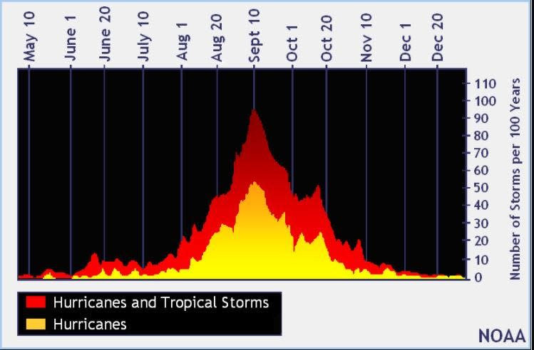
The peak of the season is Sept. 10, with the most activity happening between mid-August and mid-October, according to the Hurricane Center.
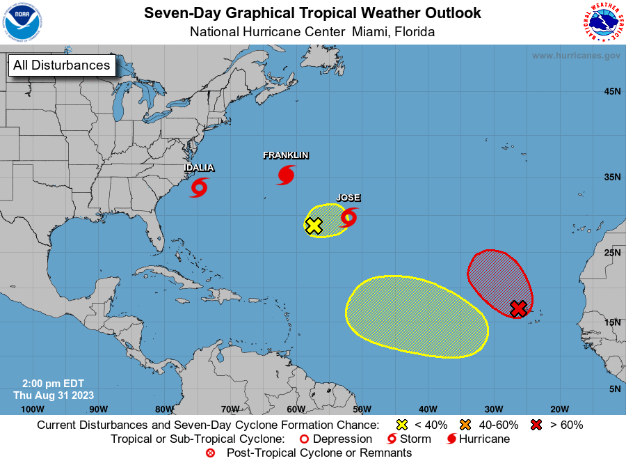
Tropical forecast over the next seven days
Excessive rainfall forecast
What's out there?
Systems currently being monitored by the National Hurricane Center.
What's next?
We will continue to update our tropical weather coverage daily. Download your local site's app to ensure you're always connected to the news. And look at our special subscription offers here.
This article originally appeared on Treasure Coast Newspapers: Tropical Storm Idalia, Jose, Hurricane Franklin, Invest 94L depression

