Idalia strengthened to a Category 4 hurricane on Wednesday
Article first published: Wednesday, Aug. 30, 2023, 5 a.m. ET
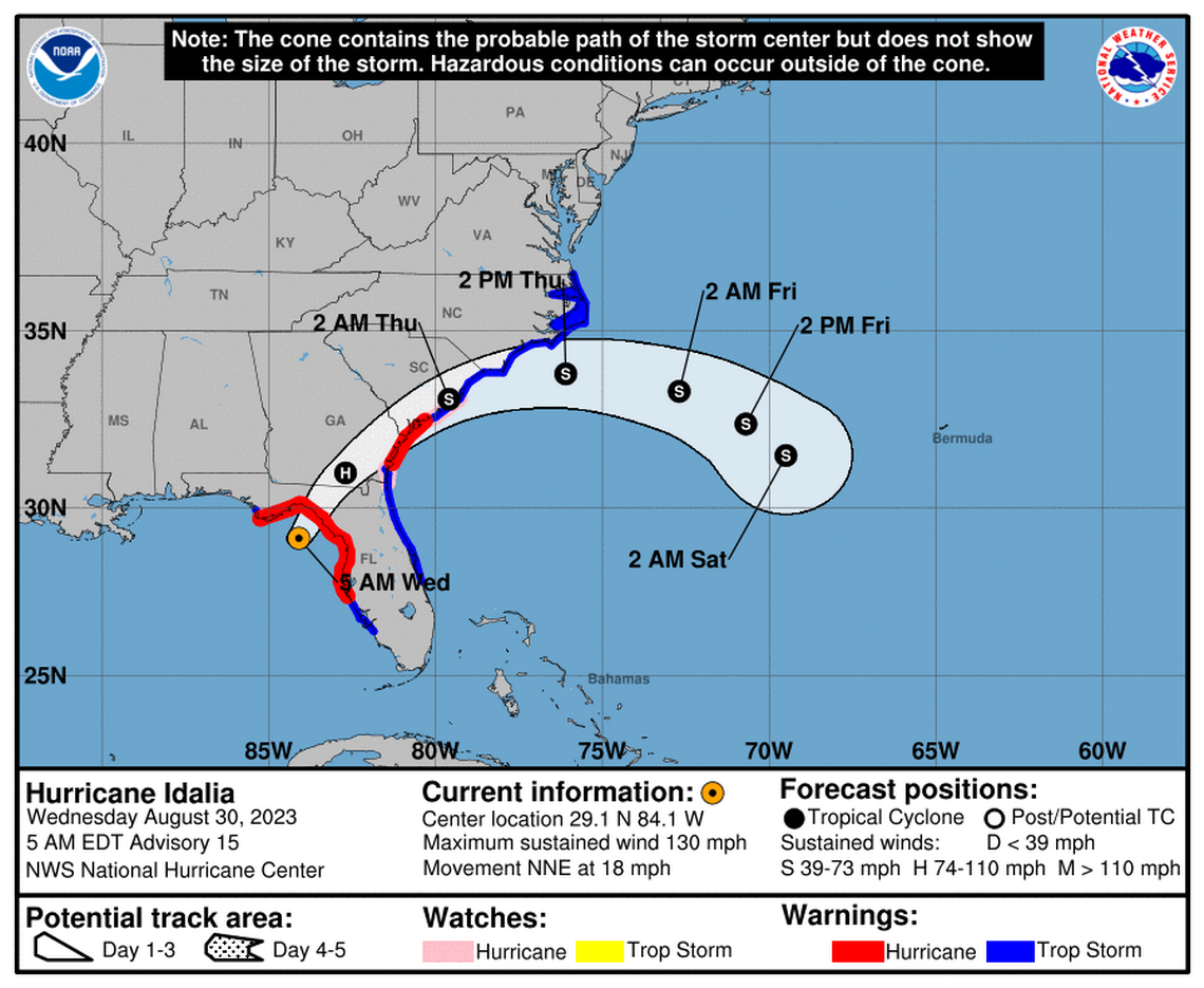
On Wednesday at 5 am, the National Hurricane Center issued an advisory stating that Idalia has become a Category 4 hurricane with sustained winds of 130 mph after intensifying from a Category 3 hurricane.
Category 4 Hurricane Idalia is 60 miles west of Cedar Key Florida and 90 miles south of Tallahassee Florida, with maximum sustained wind of 130 mph. It’s moving 18 mph to the north-northeast.
"After landfall, Idalia is forecast to turn toward the northeast and east-northeast, moving near or along the coasts of Georgia, South Carolina, and North Carolina late today and Thursday." according to analysts. "While Idalia should weaken after landfall, it is likely to still be a hurricane while moving across southern Georgia, and near the coast of Georgia or southern South Carolina late today."
YESTERDAY (Tuesday):
Yesterday, there were numerous changes: Idalia began as a Category 1 hurricane and a Category 2 hurricane but ultimately became a Category 3 hurricane with sustained winds of 120 miles per hour.
CHANGES WITH THIS ADVISORY:
A Hurricane Warning has been issued for the east coast of the United States from Altamaha Sound Georgia to Edisto Beach South Carolina.
A Storm Surge Warning has been issued from St. Catherine's Sound to South Santee River.
A Hurricane Watch has been issued from Edisto Beach South Carolina to South Santee River South Carolina.
A Tropical Storm Warning has been issued from North of Surf City North Carolina to the North Carolina/Virginia border, and Pamlico and Albemarle Sounds.
The Tropical Storm Warning for the west coast of Florida from Bonita Beach southward is discontinued.
SUMMARY OF WATCHES AND WARNINGS IN EFFECT:
A Storm Surge Warning is in effect for:
- Englewood northward to Indian Pass, including Tampa Bay
- St. Catherine's Sound to South Santee River
A Hurricane Warning is in effect for:
- Middle of Longboat Key northward to Indian Pass, including Tampa Bay
A Tropical Storm Warning is in effect for:
- Chokoloskee northward to the Middle of Longboat Key
- West of Indian Pass to Mexico Beach
- Sebastian Inlet Florida to Surf City North Carolina
A Storm Surge Watch is in effect for:
- Bonita Beach northward to Englewood, including Charlotte Harbour
- Mouth of the St. Mary's River to St. Catherine's Sound Georgia
- Beaufort Inlet to Drum Inlet North Carolina
- Neuse and Pamlico Rivers North Carolina
A Hurricane Watch is in effect for:
- Mouth of the St. Mary's River to Altamaha Sound
- Edisto Beach to South Santee River
A Hurricane Warning means that hurricane conditions are expected somewhere within the warning area. Preparations to protect life and property should be rushed to completion.
A Storm Surge Warning means there is a danger of life-threatening inundation, from rising water moving inland from the coastline, during the next 36 hours in the indicated locations. For a depiction of areas at risk, please see the National Weather Service Storm Surge Watch/Warning Graphic, available at hurricanes.gov. This is a life-threatening situation. Persons located within these areas should take all necessary actions to protect life and property from rising water and the potential for other dangerous conditions. Promptly follow evacuation and other instructions from local officials.
A Tropical Storm Warning means that tropical storm conditions are expected somewhere within the warning area.
A Storm Surge Watch means there is a possibility of life- threatening inundation, from rising water moving inland from the coastline, in the indicated locations during the next 48 hours. For a depiction of areas at risk, please see the National Weather Service Storm Surge Watch/Warning Graphic, available at hurricanes.gov.
A Hurricane Watch means that hurricane conditions are possible within the watch area.
Additional warnings could be required later today.
HAZARDS AFFECTING LAND:
STORM SURGE: The combination of storm surge and tide will cause normally dry areas near the coast to be flooded by rising waters moving inland from the shoreline. The water could reach the following heights above ground somewhere in the indicated areas if the peak surge occurs at the time of high tide... Wakulla/Jefferson County, FL to Yankeetown, FL...12-16 ft Ochlockonee River, FL to Wakulla/Jefferson County, FL...8-12 ft Yankeetown, FL to Chassahowitzka, FL...7-11 ft Chassahowitzka, FL to Anclote River, FL...6-9 ft Carrabelle, FL to Ochlockonee River, FL...5-8 ft Anclote River, FL to Middle of Longboat Key, FL...4-6 ft Tampa Bay...4-6 ft Indian Pass, FL to Carrabelle, FL...3-5 ft Middle of Longboat Key, FL to Englewood, FL...3-5 ft Saint Catherines Sound, GA to South Santee River, SC...3-5 ft Englewood, FL to Bonita Beach, FL...2-4 ft Beaufort Inlet, NC to Ocracoke Inlet, NC...2-4 ft Mouth of the St. Mary's River to Saint Catherines Sound, GA...2-4 ft Charlotte Harbor...2-4 ft Neuse and Bay Rivers...2-4 ft Pamlico and Pungo Rivers...2-4 ft Flagler/Volusia County Line, FL to Mouth of the St. Mary's River...1-3 ft Mexico Beach, FL to Indian Pass, FL...1-3 ft Bonita Beach, FL to East Cape Sable, FL...1-3 ft South Santee River, SC to Beaufort Inlet, NC...1-3 ft Ocracoke Inlet, NC to Duck, NC...1-3 ft The deepest water will occur along the immediate coast near and to the right of the center, where the surge will be accompanied by large and destructive waves. Surge-related flooding depends on the relative timing of the surge and the tidal cycle, and can vary greatly over short distances.
WIND: Hurricane conditions are expected within the hurricane warning area in Florida soon, with tropical storm conditions spreading northward and westward through this morning.
Tropical storm conditions will continue within the tropical storm warning area along the Florida Gulf and west coasts.
Hurricane conditions are expected in the Hurricane Warning area along the coasts of Georgia and South Carolina later today and tonight.
Hurricane conditions are possible in the Hurricane Watch area along the coasts of Georgia and South Carolina later today and tonight.
Tropical storm conditions are expected to begin later today in the warning area along the east coast of Florida, Georgia, and South Carolina, and spread into North Carolina tonight and Thursday.
RAINFALL: Idalia is expected to produce a swath of 4 to 8 inches of rainfall with isolated maxima up to 12 inches from the Florida Big Bend through central Georgia and South Carolina, and through eastern North Carolina into Thursday. These rainfall amounts will lead to areas of flash, urban, and moderate river flooding, with considerable impacts.
SURF: Swells generated by Idalia are affecting the southwestern coast of Florida and will spread northward and westward to the north-central Gulf coast through today. These swells are likely to cause life-threatening surf and rip current conditions.
TORNADOES: A few tornadoes are possible this morning across west-central and northern Florida into southeast Georgia, with the tornado risk shifting toward the coastal Carolinas this afternoon and tonight.
Source: National Hurricane Center
This article was generated by the Miami Herald Bot, artificial intelligence software that analyzes information from the National Hurricane Center and applies it to templates created by journalists in the newsroom. We are experimenting with this and other new ways of providing more useful content to our readers and subscribers. You can report errors or bugs to mcclatchybot@mcclatchy.com. Full hurricane coverage at miamiherald.com/news/weather/hurricane/

