Hurricane Idalia expected to be an ‘extremely dangerous’ Cat 4 when it makes Florida landfall
- Oops!Something went wrong.Please try again later.
It’s “crunch time” for Florida as it braces for Hurricane Idalia’s impact — a possibly catastrophic storm not seen in more than a century, Gov. Ron DeSantis said.
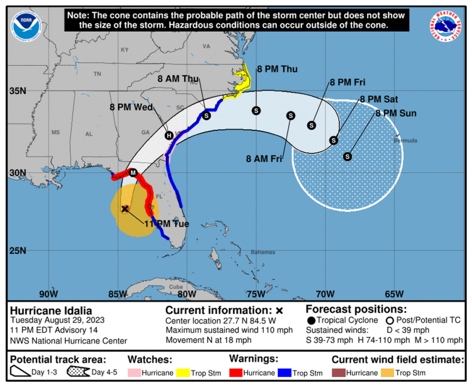
Forecasters now predict Idalia will make landfall on the state’s Big Bend region as an “extremely dangerous” Category 4.
“If you are there when that hits, it is going to be very difficult to survive that,” DeSantis said.
The latest National Hurricane Center forecast at 11 p.m. still had Idalia on track to make landfall in the Big Bend area on Wednesday morning as a dangerous major storm.
With sustained winds of 125 mph as of 4 a.m. Wednesday, Idalia is now a Category 3. Prime conditions will fast-track the storm to a Category 4 within the next 12 hours, forecaster say.
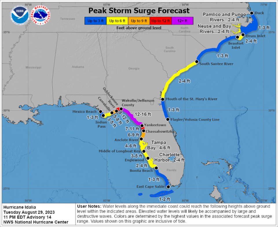
Near its powerful core, sustained winds could hit 130 mph, a jump from earlier projections, and storm surge could reach up to 16 feet.
The flooding threat extended far beyond the cone of concern for high winds. From Apalachicola to the Florida Keys, much of the state’s west coast remained blanketed with storm surge and hurricane warnings, and officials warned that Idalia’s rain, tornadoes and surge will be felt far from the strike zone.
The densely populated Tampa Bay region, for instance, was facing a record 4 to 6 feet of surge. Forecasters also cautioned that the track could still shift.
Apart from flooding, most of Florida’s Gulf Coast was put under a tornado watch until 6 a.m. Wednesday due to Idalia.
DeSantis urged Floridians to prepare for a major hurricane that will cause serious damage.
“We are going to be hit by a major hurricane,” he said in a Tuesday night news conference. “The eye will arrive onshore sometime tomorrow morning most likely, and it is going to have major impacts, particular in Florida’s Big Bend region.”
He emphasized that a storm of this magnitude — bringing what officials are calling “greatly concerning” storm surge — hasn’t made landfall in the Big Bend since the late 1800s.
At this point, there is growing certainty of a landfall in the Taylor, Dixie or Levy County region, which has largely been untested by a major storm. The Tallahassee office of the National Weather Service underlined that in a morning forecast discussion post.
“To put this system into the historical context, there are NO major hurricanes in the historical data set going back to 1851 that have tracked into Apalachee Bay. None. Don’t mess around with this,” forecasters wrote.
Storm surge risk grows
Idalia is becoming increasingly organized as it approaches Florida’s Big Bend area at a brisk pace, growing stronger as encounters low sheer and hot water conditions in the Gulf of Mexico.
In the 11 p.m. update, the hurricane center upped Idalia’s wind speed predictions for landfall due to this storm-friendly environment — calling for 130 mph maximum sustained winds when it comes ashore.
In these final hours before landfall, the hurricane is going over some of the warmest water in the Gulf where sea surface temperatures are nearly 90 degrees Fahrenheit.
Unfortunately #Idalia has yet to traverse the warmest waters in the Gulf of Mexico, which warm to 31-32C close to the Florida Gulf Coast. Map via @BMcNoldy. pic.twitter.com/PikG52C469
— Philippe Papin (@pppapin) August 29, 2023
The forecast also moved its track a bit more west, just another of a series of nudges west over the past few days that closely follow other storm models.
Idalia also picked up the pace on Tuesday, from a leisurely 8 mph speed overnight up to 18 mph, as it sailed north into the Gulf of Mexico. Propelled by helpful steering winds, the storm was expected to remain fast as it rockets across the northern half of the state Wednesday and Thursday.
When Idalia comes ashore, it will bring destructive life-threatening winds, spreading inland across northern Florida. Forecasters are warning residents to be prepared for long-duration power outages.
The risk of storm surge is especially high for this storm as well. Storm surge is the No. 1 killer in hurricanes and the reason for the evacuation orders that have been called up and down the coast.
Coastal spots in Jefferson, Taylor, Dixie and Levy counties were expected to see the worst as of the Tuesday night forecast — 12 to 16 feet of surge above ground level.
“We’re going to have destructive wave action on top of that that can actually destroy homes and buildings and make this a place that is difficult to survive,” Michael Brennan, director of the National Hurricane Center, said in a Tuesday morning video update.
South Florida felt the first bands of Idalia’s gusty winds Tuesday afternoon in the Keys, which are also expected to see a couple of feet of storm surge. Miami-Dade and Broward are mostly out of the hot seat, but gusts of strong winds — as well as a couple of inches of rain — began Tuesday evening. The rain and wind are expected to continue through Wednesday evening.
Idalia was not expected to be a huge rainmaker, but even a few inches could cause flooding in coastal South Florida, since Wednesday is the first king tide, the annual series of highest tides, of the year.
As of 4 a.m. Wednesday, Hurricane Idalia was about 90 miles west of Cedar Key and 60 miles south of Tallahassee, with maximum sustained winds of 125 mph. It was headed north at 17 mph with tropical-storm-force winds extending out up to 160 miles from the center. Hurricane-force winds extended out 25 miles from the center.
Officials urge residents to evacuate from historic storm
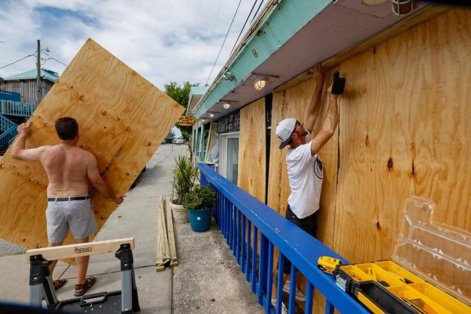
Evacuations were already underway in 27 counties, and major theme parks, schools, airports and universities have closed in anticipation of Idalia’s arrival.
Earlier in the day, Desantis pleaded for residents to follow evacuation orders and keep themselves and their families safe.
READ MORE: When will Florida feel the worst weather from Hurricane Idalia? See times for each area
“By the time we get to the end of tonight, you’re gonna see some nasty weather,” DeSantis said in a morning news conference. “Be warned about that and do what you need to do right now to keep yourself and your family safe.”
He ran through numbers to emphasize the state’s preparations – 55,000 National Guardsmen ready, 42,000 gallons of fuel available, and 25,000 linemen already stationed.
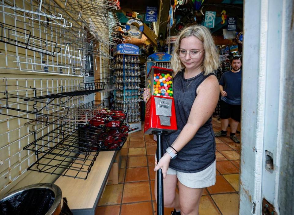
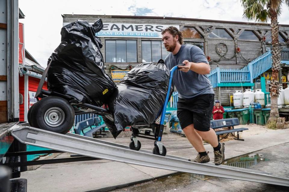
In Cedar Key, police were knocking on doors to convince residents, like Carol Carlin, to evacuate. Carlin, 28, spent the morning packing clothes at the shop her family has owned for about 13 years, Island Trading Post.
“If you look at it from the outside, it’s not the best,” she said during a brief break from packing. “This whole town is very, very old, so a lot of the infrastructure that’s on Second Street … it’s been there for 100-plus years. I’m just really worried it might not be the same when we get back.”
Carlin said many are leaving the tiny Gulf Coast town, which has a population of less than 700. But a friend has insisted on staying on the island, she said.
“He said his house is rated for a category 5 storm, but is it?” she said, with a furrowedbrow. “It’s never been tested.”
Government help on the way
The director of the Federal Emergency Management Agency, in a Tuesday afternoon media conference at the White House, said the agency was prepared to respond to Idalia, including with search-and-rescue teams.
“They are all ready to pivot to the most impacted areas immediately after the storm,” FEMA Director Deanne Criswell told reporters. “We also have warehouses filled with commodities like food, water, blankets and medical supplies that are ready to rapidly move to the impacted area at the state’s request.”
Criswell said she spoke on the phone with DeSantis on Monday about coordinated state and federal preparations. The governor told Criswell, she said, that he was worried about people taking the storm seriously as well as making sure vulnerable people receive the help they need to evacuate away from the storm’s path.
The American Red Cross has also been readying supplies, said Brad Kieserman, vice president for disaster operations, in a Tuesday afternoon media call. He noted that there are more than 20,000 individual supplies stocked in Jacksonville, 75 vehicles to hand out meals and other supplies, and 100,000 shelf-stable meals.
“We have been moving supplies now for over 72 hours,” he said.
Kieserman said the Red Cross has staff placed in several counties, including Volusia, Seminole, Pasco, Hardee, Dixie, Taylor and Columbia Counties, but the plan is to focus on “vulnerable, rural communities” after landfall.
Particularly of concern in some of the counties are elderly and disabled people, said Sherman Gillums, Jr., director of FEMA’s office of disability, integration and coordination. Gillums said about 14.5% of the total population of all counties under evacuation orders are disabled, more than 1.5 million people.
Some of those counties with mandatory evacuation orders either do not have special needs shelters or do not have enough space in them for the demand in the county, according to state documents. If that’s the case, Gillums urged anyone to simply go to the nearest shelter to them, which is required to be ADA accessible.
“I would see other shelters as non-options for people with disabilities,” he said.
Kieserman, with the Red Cross, echoed Gillums and said Floridians should get to safety first, then call the Red Cross and ask for additional help meeting their needs if the current shelter does not provide it.
“Don’t wait to get out of the path of the storm, we can always relocate later,” he said.
Tampa Bay Times/Miami Herald Tallahassee Bureau staff writer Romy Ellenbogen and McClatchy DC White House Correspondent Alex Roarty contributed to this report.

