Lee makes landfall in Canada with impacts felt in New England: Power outages, downed trees
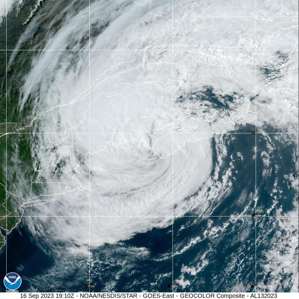
Once a Category 5 hurricane, Lee finally made landfall in eastern Canada on Saturday afternoon as a post-tropical cyclone, bringing with it near hurricane-strength winds, "life-threatening" surf and potential flooding.
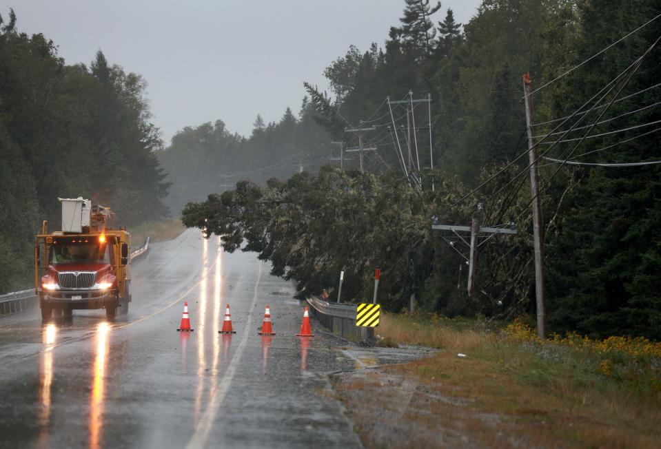
The storm had already toppled trees, inundated boats and cut power to tens of thousands from Maine to Nova Scotia on Saturday morning. It made landfall on Long Island in Nova Scotia just below hurricane strength at about 4 p.m., the National Hurricane Center said.
The storm is expected to turn toward the northeast and move across Atlantic Canada in the evening and through Sunday, weakening as it goes.
Tens of thousands of people were reporting power outages throughout Saturday, including more than 95,000 customers in Maine and nearly 150,000 in Nova Scotia around 5 p.m., according to power outage trackers.
Tropical storm conditions are affecting parts of coastal New England, with heavy rainfall that can produce flooding in the eastern parts of Massachusetts and Maine, where a state of emergency has been declared, plus the Canadian provinces of New Brunswick and Nova Scotia.
"The strong winds are likely to lead to downed trees and potential power outages," the hurricane center said.
Storm effects were piling up in Canada, where coastal roads in Nova Scotia were flooded and boats along the harbor in St. Margarets Bay were inundated.
What's a post-tropical cyclone?
Lee completed its transition from a hurricane to a post-tropical cyclone Saturday morning, although it was still packing hurricane-force winds.
What is a post-tropical cyclone? It's when a hurricane loses its tropical characteristics and becomes more "extra-tropical," associated with fronts and a larger wind field, said meteorologist Sara Johnson, with the National Weather Service in Gray/Portland, Maine. Post-tropical cyclones can still carry heavy winds and rains, the weather service says.
"Please do not let the naming convention detract from the still dangerous storm which is expected to bring strong winds and dangerous seas to the area," Johnson said.
Where is Lee now?
Lee made landfall on Long Island in Nova Scotia on Saturday at 4 p.m. By evening, it was moving over the Bay of Fundy between New Brunswick and Nova Scotia, putting it about 50 miles out of Eastport, Maine, and 125 miles west of Halifax, Nova Scotia, moving north at 16 mph with maximum sustained winds of 70 mph.
Rain and wind in coastal New England
Coastal parts of New England states experienced strong winds and are expecting potential localized flooding, forecasters said.
Wind gusts have been recorded up to 62 mph in the very coastal parts of Massachusetts, the National Weather Service in Boston said Saturday morning. "Further across the interior it's been a relatively quiet start to the weekend other than light rain and breezy winds," the weather service said.
In eastern Massachusetts and Maine, between 1 and 4 inches of rain is expected on Saturday, the hurricane center said.
Storm surge values are peaking around Cape Cod and Nantucket at about 2.5 feet, said Andy Nash, meteorologist-in-charge of the National Weather Service office in Boston. The surge around Boston, peaked at around 1.6 feet. With the continued northwest wind, water levels are still forecast to run high on the north side of Nantucket for the upcoming high tide
Inside Cape Cod Bay, Nash said he expects to see a bit more of a rise in water levels as the northwest winds push the water from the west side of Cape Cod bay eastward on Saturday. It might be enough to cause minor flooding along the coast, he said, similar to the highest high spring tides.
How common are tropical storms in New England?
Destructive hurricanes are relatively rare this far to the north. The Great New England Hurricane of 1938 brought gusts as high as 186 mph and sustained winds of 121 mph at Massachusetts’ Blue Hill Observatory. But there have been no storms that powerful in recent years.
The region learned the hard way with Hurricane Irene in 2011 that damage isn’t always confined to the coast. Downgraded to a tropical storm, Irene still caused more than $800 million in damage in Vermont.
Farther from path of storm, surfers brave the waves
Early Saturday, three dozen surfers converged on the clean green curls peeling in on Point Judith, on the western side of Narragansett Bay in Rhode Island. Peter Ryan, usually a bird photographer, came to the lighthouse hillside to capture their rides.
“I was hoping to catch some waves breaking over the wall” on the other side of the lighthouse, he said. “But I walked over there and there wasn’t a wave. I couldn’t believe it."
Surfer Jacob Abraham spent the early morning on the swells east of Point Judith light with dozens of other like-minded wave aficionados.
He rated the waves a 5-6 out of 10 and appreciated their “clean” formations. “Friday it was really messy out here.”
That may not be so advisable in coastal areas farther north, officials warned.
Kyle Leavitt, director of the New Brunswick Emergency Management Organization in Canada, urged residents to stay home, saying, “Nothing good can come from checking out the big waves and how strong the wind truly is.”
Contributing: The Providence Journal; the Associated Press
This article originally appeared on USA TODAY: Storm Lee landfall in Canada: Updates on power outages, forecast

