Incoming California storms linked to strong El Niño in Pacific


The long-awaited wet season for California has been absent so far, but there are signs that rain and mountain snow may not be far off for the Golden State, AccuWeather meteorologists say.
California generally has some of the first rain events of the winter season in late October, but the period from the second half of November to December often brings an increase in Pacific storms packed with moisture.
"It has been a very dry start to the wet season in California, unlike last winter," AccuWeather Chief On-Air Meteorologist Bernie Rayno said.
Last year, the weather ramped up in early November when a storm brought 1-2 inches of rain to San Francisco and Los Angeles. The wet season accelerated last December, when 9.66 inches of rain drenched San Francisco and 2.81 inches of rain poured down on Los Angeles.
 |
Faithful participate in a bilingual Mass under rain at East Los Angeles College (ELAC) Stadium in Los Angeles, Sunday, Dec. 4, 2022. (AP Photo/Damian Dovarganes) |
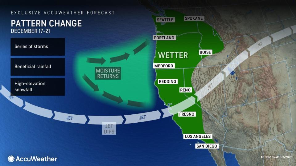
While the wet season is experiencing a bit of a delayed start, AccuWeather meteorologists believe that it will build in the days prior to Christmas, but perhaps not to the extent of last winter.
A weak storm will struggle to push clouds and showers onshore by Sunday afternoon in coastal areas of Northern California, while the balance of the state remains dry through the weekend.
However, moisture will reload significantly over the nearby Pacific next week.
 |
Areas of rain and wet travel will push inland over Northern and Central California and expand northward to western Oregon and Washington from Sunday night to Monday night.
"Snow levels will be fairly high through early next week, remaining mainly above 8,000 feet in the northern Sierra Nevada, so for most places, except for the high country, this will be just a rain event," AccuWeather Meteorologist Haley Tayor said.
Even though the timing of a more potent storm for next week depends on the movement and strength of other weather features in North America, there is an indication that a series of storms will start by the middle of next week and continue beyond Christmas.
"Focus will turn to a storm that is expected to drop southeastward toward California from Tuesday to Friday," Taylor said, adding, "This storm should ride along the California coast before moving inland somewhere near Southern California or Baja California, Mexico."
 |
The storms coming next week will likely be the most significant of the rainy season so far, including for Southern California.
There is the potential for the Los Angeles basin to pick up 1-2 inches of rain with locally higher amounts on the mountainsides, Taylor said.
Since Hillary brought 2.99 inches to downtown Los Angeles in mid-August, the city has only picked up 0.41 of an inch of rain. So the storms from the middle and latter part of next week have the potential to bring the most significant rain to the region in months.
Depending on the track of the storm later next week, and how quickly it pushes inland, snow levels may drop to below the passes in Northern and Central California.
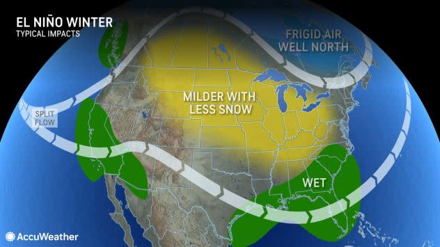
One of the driving forces behind an anticipated storm-packed winter for the West Coast in general will be potentially historically strong El Niño.
An El Niño occurs when a stream of warm water develops and persists in the eastern subtropical Pacific, AccuWeather Senior Meteorologist Brett Anderson explained. Water temperatures in this part of the Pacific were approaching 2.0 degrees Celsius (4 degrees Fahrenheit) above the historical average as of mid-December.
"This warm plume of water creates a strong temperature contrast zone and results in an active southern jet stream and storm track," Anderson said, adding, "Depending on other conditions, that storm track can be directed into California."
 |
This image shows sea surface temperature departures from the historical average on Dec. 11, 2023. Shades of orange and red depict warmer-than-average water, while shades of blue depict cooler-than-average water. The El Niño warm water temperature signature (orange) is clearly visible in the center of the image. A pocket of cool water (blue) prevails southeast of Hawaii. (NOAA) |
There is a 54% chance that the current El Niño could end up being historically strong and among the top five strongest on record, according to the latest update from the National Weather Service Climate Center.
The El Niño pattern and an associated subtropical branch of the jet stream have been delivering rounds of rain to parts of the Southeast states and will continue to do so into this weekend. However, until now, storms have not impacted much of California.
AccuWeather meteorologists caution that not all El Niños are created equal, and the strength of El Niño could be diminished by other factors. The underlying problem as far as storms missing California so far has to do with variable sea surface temperatures north of the tropical Pacific.
"There is a large puddle of cool water sitting offshore over the Pacific, southeast of Hawaii, and that has been altering the effects of El Niño thus far," AccuWeather Lead Long-Range Meteorologist Paul Pastelok said.
 |
An El Niño pattern often ushers in an active storm track and resultant wetter conditions than the historical average across southern parts of the U.S. |
If the cooler-than-average waters remain southeast of Hawaii, this can force the storm track to be farther south, directed more toward Mexico and the Gulf of Mexico rather than California.
"However, if this cool water zone is able to warm up, then the subtropical jet stream, and the storms it brings, could return to a typical strong El Niño position over Southern California and into more of the southern United States in general," Pastelok added.
The upcoming pattern change for California will most likely be gradual, with some opportunities for rain and mountain snow for the second half of December. However, the pattern may become more intense in the coming weeks and months, depending on El Niño and other factors, such as surrounding sea surface temperatures in the Pacific.
Want next-level safety, ad-free? Unlock advanced, hyperlocal severe weather alerts when you subscribe to Premium+ on the AccuWeather app. AccuWeather Alerts™ are prompted by our expert meteorologists who monitor and analyze dangerous weather risks 24/7 to keep you and your family safer.
