‘Increasing confidence’ that Lee will become ‘very powerful hurricane’ by weekend
- Oops!Something went wrong.Please try again later.
FORT LAUDERDALE, Fla. — Tropical Storm Lee is gaining strength in the Atlantic and likely will develop into an “extremely dangerous” major hurricane with wind speeds of 145 mph by the weekend as it travels west toward the Caribbean and Bahamas, forecasters said Tuesday.
It would be the fourth hurricane of the 2023 Atlantic season.
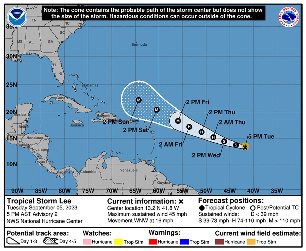
The system was 1,315 miles east of the eastern Caribbean late Tuesday afternoon, moving west-northwest at 16 mph with maximum sustained winds of 45 mph. The National Hurricane Center predicted it would become a hurricane by Thursday morning, and a major hurricane with wind speeds greater than 111 mph by Friday afternoon.
Forecasters said “it is becoming a question of when and not if” Lee will rapidly intensify. Wind shear “could keep Lee in check for the next day or two,” but that is expected to decrease by Friday, allowing Lee to rapidly intensify as it moves over abnormally warm water.
“There is increasing confidence on Lee becoming a very powerful hurricane by this weekend,” the hurricane center said.
Its trajectory has it headed in the general direction of the Bahamas and potentially Florida.
It was too early to know exactly how close the system will get to the islands of the eastern Caribbean, though they could feel impacts by the weekend, the National Hurricane Center’s Tuesday afternoon update said. The current cone indicating the probable path of the eye of the storm sits just north of Puerto Rico.
Several forecasting models show the storm steering north at some point. It remains unclear when, exactly, that would happen, and where that would place the storm. A sharp turn north would take the storm away from South Florida.
“The high pressure to the north of it, that’s what’s going to steer it,” said Anthony Reynes, senior forecaster with the National Weather Service in Miami.
“Tropical systems, they cannot go against the flow of the high pressure, they have to go around it ... once it moves to the north of Puerto Rico, it’s going to start shifting more to the north and eventually northeast. The cyclone is moving around the edge of that high.”
There also will be a low pressure trough moving east over the U.S. that should also contribute to the northward motion of the storm, he said.
The system will be traveling over record-warm water, close to 86 degrees. Their long-range forecast said winds could reach up to 145 mph.
Lee’s structure was becoming better organized throughout the day Tuesday, producing showers and thunderstorms about 900 miles west-southwest of Africa’s Cabo Verde Islands.
The National Weather Service Miami said Tuesday night on the social media platform X, formerly known as Twitter, that South Florida is not expected to be directly impacted but reminded South Floridians that it is now peak hurricane season and to ensure supplies are ready.
As of Tuesday, there have been three Atlantic hurricanes this season — Don, Franklin and Idalia, the latter two of which were major hurricanes.
Another tropical depression could form later in the week or this weekend from a tropical wave off the coast of Africa and move west-northwest toward the central tropical Atlantic.
As of 8 p.m. Eastern time Tuesday, its odds of developing were at 60% within seven days, and 30% within two days. It will move over the Cabo Verde Islands off Africa on Wednesday night and Thursday, the hurricane center said.
Meanwhile, the remnants of Hurricane Franklin were given a 10% chance of gaining “some subtropical or tropical characteristics” in the next seven days over the warm waters near Portugal. It is not expected to further develop, though, by later in the week.
Tropical Storms Katia and Gert dissipated Monday.
The National Hurricane Center, which operates under the National Oceanic Atmospheric Administration, has forecast 14 to 21 named storms, including six to 11 hurricanes, and two to five major hurricanes.
The National Hurricane Center has been predicting an “above-normal” 2023 hurricane season as a result of ongoing record-breaking sea surface temperatures that continue to fight off the tempering effects of El Niño.
While sea-surface temperatures have remained hot for longer than anticipated, El Niño’s effects, which typically reduce hurricane chances, have emerged more slowly.

