Incredible Technology: How to Track Hurricanes
Editor's Note: In this weekly series, LiveScience explores how technology drives scientific exploration and discovery.
Hurricane tracking and forecasting save lives. In sparsely populated Florida in the 1920s and 1930s, hurricanes killed thousands of people. The storms arrived without little to no warning. Now, thanks to forecasters who monitor incoming storms, millions of Floridians can evacuate days before storm surge flooding and winds hit.
The technology for monitoring hurricanes may sound old-fashioned — weather satellites and specially equipped planes. But NASA has added unmanned aircraft, or drones, to the country's arsenal of hurricane-hunting aircraft, and a planned weather satellite will soon peer through clouds to scan rainfall inside a hurricane, providing 3D views. The data feeds into weather models that run on supercomputers, and scientists are always looking for new tweaks that will improve storm forecasts.
Hurricane hunters: tracking by air
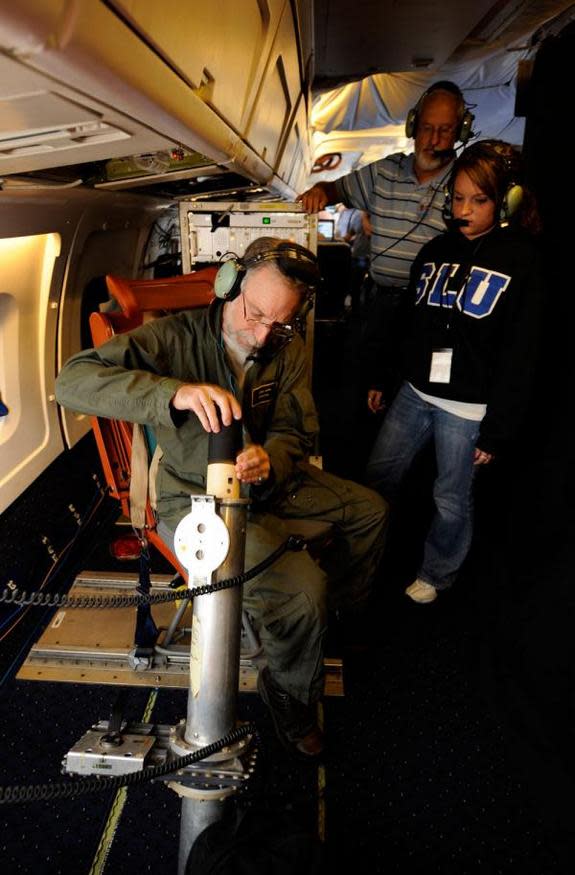
The first time a plane flew into a hurricane on purpose was in 1943, near Galveston, Texas. Now, a group of pilots and scientists called the Hurricane Hunters regularly soar through storms that threaten the United States. Aircraft from the U.S. Air Force and the National Oceanic and Atmospheric Administration (NOAA) gauge wind speeds, barometric pressure, rainfall and snow. They also release sensors called dropsondes, which fall through the storm and send back data in real time to improve forecasting models. The dropsondes descend by parachute, relaying two to four measurements per second by radio to aircraft nearby. [Video: Ride With Hurricane Hunters Into Irene's Eye]
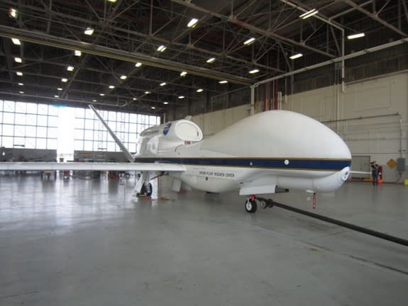
NASA is also sending two Global Hawk drones lofting above hurricanes as part of a five-year science mission to investigate the influence of weather patterns across the Atlantic on tropical storms, and how hurricanes grow and wane.
Between the Hurricane Hunters and NASA, six planes from three government agencies have flown at the same time in one hurricane (2010's Hurricane Karl), each in different parts of the storm.
Even though data from the remotely piloted Global Hawks is not used for weather forecasting, the science can help to improve hurricane-forecasting models, said Scott Braun, chief scientist for the NASA mission.
"We're interested in the processes that control storm formation and intensification," Braun said. When the drones watched Hurricane Nadine in 2012, they saw the storm lose strength, then intensify again into a hurricane after wandering around the Azore islands for a few weeks. "We're hoping to learn something about how the storm was able to redevelop when the environmental conditions were quite adverse," Braun said. "One would have anticipated that storm would have quickly dissipated."
Satellites: weather watchers in space
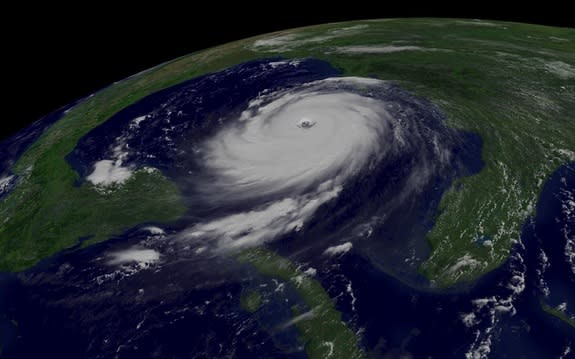
Weather satellites watch hurricanes from orbit, snapping visible images of swirling clouds and measuring weather patterns with radar and infrared sensors. Today's satellites can track temperatures inside a storm, cloud heights, rain, snow and wind speed.
NOAA tracks developing storms and makes long-term forecasts with two sets of satellites: geostationary operational environmental satellites (GOES) and polar-orbiting operational environmental satellites (POES). The GOES satellites hover above the same spot for their life spans, and the POES satellites circle the planet in above the poles 14 times a day. [Time-Lapse Video: 10 Years of GOES Weather Monitoring]
But one of the most useful satellites for monitoring hurricanes wasn't meant for storm-watching at all.
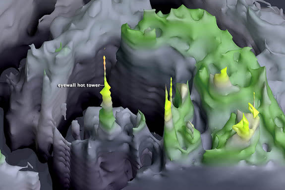
The TRMM satellite, or Tropical Rainfall Measuring Mission, launched in 1997. Intended to measure rainfall in the tropics, the satellite quickly proved invaluable for providing "CT scans" inside hurricanes. The radar on the TRMM satellite sees inside storms, including a newly recognized phenomenon called hot towers. Thanks to TRMM, forecasters now know that storms with hot towers — rain clouds that reach the top of the troposphere — are more likely to intensify in the next 24 hours. The troposphere is the lowest layer of the atmosphere, and hot towers bring heat up to these high altitudes.
"TRMM was the first and only rainfall radar in space," said Braun, who is a research meteorologist. "Ultimately, what it provides is a CT scan beneath the clouds. It's like a three-dimensional view."
A new satellite that improves on TRMM is planned for launched in February 2014 by NASA and the JapanAerospace Exploration Agency. Dubbed the Global Precipitation Measurement (GPM) satellite, it will take a snapshot of rain and snow between 65 degrees latitude North and South every three hours.
Supercomputers: where it all comes together
Pacific hurricane warnings were issued as early as the late 1800s, but hurricane forecasts didn't come until 1954, with a day's advance warning of a storm track. By 1964, meteorologists could draw a hurricane track out to three days. This remained the standard for nearly four decades. In 2002, thanks to better storm models and more powerful computers, NOAA started releasing five-day forecasts of tropical storms and hurricanes. [Infographic: Storm Season! How, When & Where Hurricanes Form]
The weather models improved with new understanding of global ocean and atmospheric patterns that influence budding storms. But when researchers offer a tweak, such as computer algorithms that analyze satellite images for hot towers in hurricanes, NOAA wants reliability. So new algorithms are tested in real time at a computer complex in Boulder, Colo. The tests run side-by-side with current forecast models, taking on incoming feeds from weather satellites, ocean sensors and the hurricane hunters, said Frank Marks, director of NOAA's Hurricane Research Division. The computer-model newbies also have to prove their mettle against 1,000 past storms.
"Researchers are always looking for the next innovation, but in operations, you're only as good as what you did yesterday," Marks said.
Another advance: NOAA recently unveiled two new supercomputers in 2013, one in Reston, Va., and a backup in Orlando, Fla. Both run at a peak speed of 213 teraflops (213 trillion operations per second), more than twice the processing power of the last set of weather supercomputers.
"About every five years, we get better computers, and that's one of the ways in which hurricane forecasting has been improving steadily over the last 20 years," said David Nolan, a meteorology professor at the University of Miami's Rosenstiel School of Marine and Atmospheric Science. "Another is just improving our understanding of the physics of hurricanes."
Even with the boost in computing power, scientists still face a limit. To improve intensity forecasts — the Category 1 through 5 scale — meteorologists need more accurate wind speed measurements. But hurricanes are so huge compared with planes and dropsondes that improving accuracy has been a hurdle for nearly two decades.
"The 24-hour intensity forecast has had an error of 10 to 12 knots [18 km/h to 22 km/h] over the last 20 years," Nolan said. "We can only measure hurricanes to an accuracy of plus or minus 10 knots, and you can't predict something better than you can measure it."
Email Becky Oskin or follow her @beckyoskin. Follow us @livescience, Facebook & Google+. Original article on LiveScience.
Copyright 2013 LiveScience, a TechMediaNetwork company. All rights reserved. This material may not be published, broadcast, rewritten or redistributed.
