Ingredients to come together for significant severe weather outbreak


 |
Looking ahead to next week, AccuWeather meteorologists are monitoring for a potential severe weather outbreak across the southern United States on Tuesday and Wednesday that could pose a significant threat to life and property due to a strong storm system and jet stream setup.
The severe storm dangers next week will arrive right around a time that may already be triggering for millions that could be affected. Part of the outbreak could overlap with the 10-year anniversary of the Super Tornado Outbreak in 2011, an infamous event that spawned hundreds of tornadoes and claimed hundreds of lives across the South.
Once again, all of the necessary ingredients will come together for severe weather to develop. A strong storm system will shift into the region as a robust jet stream hovers overhead. Big dips in the jet stream often occur during April, an active month for severe weather, which, in turn, helps to provide extra energy for big thunderstorms and severe weather outbreaks to ignite.
Another reason that severe weather typically ramps up in April is the fact that major surges of warm and moist air from the Gulf of Mexico collide with lingering chilly air across the north.
Tornadoes are pacing well below normal so far in April, which is a departure from the trends in late February and March, which unleashed devastating and deadly rounds of severe weather and tornadoes. Only 34 tornadoes touched down in the United States between April 1 and April 20, according to the Storm Prediction Center (SPC). On average, 224 tornadoes occur during the month of April in the U.S. There has been only one very active day so far this month on April 9. Thunderstorms triggered hundreds of reports of severe weather that day, but there were only nine reports of tornadoes.
 |
The setup meteorologists are nervously watching for the first part of next week involves a major undulation in the jet stream that is expected to result in a big surge in warmth over the Central and Eastern states, but at the same time, this will allow chilly air to settle over the West. In the temperature contrast zone between the two air masses, the jet stream will scream overhead and result in plenty of wind energy and a sweep of dry air.
All the ingredients are coming in line for a severe weather outbreak in the central Plains Tuesday afternoon and evening, AccuWeather Senior Storm Warning Meteorologist Eddie Walker said.
CLICK HERE FOR THE FREE ACCUWEATHER APP
"A return of moisture from the Gulf of Mexico, hefty atmospheric instability, a press of dry air from the deserts and interactions from fronts, as well as speed and directional shear," will all be present, Walker explained. The weather setup appears to be straight out of the "playbook for a major severe weather event," he said.
The change in wind direction and increase in wind speed at increasing height in the atmosphere is known as wind shear. When the wind speed increases substantial from the ground to the lower part of the atmosphere, strong gusts can occur in storms. Changes in wind direction from near the ground to the lower part of the atmosphere set the stage for rotating thunderstorms that are more likely to produce tornadoes.
"All forms of severe weather including several tornadoes, very large hail, torrential rainfall, damaging wind gusts and frequent lightning strikes appear to be likely for Tuesday," Walker said.
The ultimate determining factor may be the amount of sunshine available, AccuWeather forecasters say. Warmth from the sun, where clouds are largely absent much of the day, can make the atmosphere significantly more ripe for severe weather versus where cloudy conditions prevail and suppress temperatures.
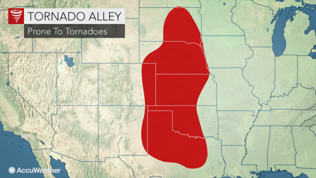
At this time, it appears the first and perhaps some of the biggest storms in the setup are likely to erupt in Oklahoma, western and central Texas and central and southeastern Kansas on Tuesday afternoon. This zone includes a portion of Tornado Alley, a zone that has often been a target of violent storms over the decades stretching from Texas to South Dakota.
 |
Storms are expected to carry on farther to the east Tuesday night in portions of Texas, western Arkansas and western Missouri.
However, the threat of severe weather and potentially violent storms will not end Tuesday night. On Wednesday, the severe weather risk is expected to focus over the middle and lower portions of the Mississippi Valley to the northwestern part of the Gulf Coast.
"Severe weather on Wednesday will be a bit more conditional, based on the eastward progression of storms from Tuesday night," Walker said, "However, areas from Des Moines, Iowa, and Chicago to Little Rock, Arkansas, Memphis, Tennessee, and Houston may be in the bullseye."
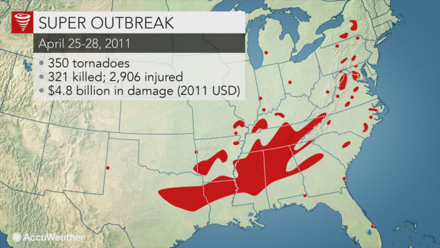
Severe weather anticipated early next week will coincide with the 10th anniversary of the Super Outbreak of 2011. Hundreds of severe thunderstorms were spawned during the event which spanned four days from April 25 to 28. The storms killed 321 people and injured nearly 3,000.
 |
At least 350 tornadoes were spawned in the Super Outbreak, including four EF5 twisters, which are the strongest on the Enhance Fujita scale, according to the National Weather Service (NWS). The strongest of these storms struck the Hackleburg/Phil Campbell, Alabama, areas with winds as high as 210 mph. During the Super Outbreak of 2011, severe storms occurred from Texas to New York state and Pennsylvania.
The 2011 Super Outbreak was centered significantly farther to the east when compared to the setup for Tuesday and Wednesday, April 27-28, 2021.
However, the setup for early next week could end up in a similar area to that of April 13-16, 2012.
 |
Workers check out the carnival that was damaged on Sunday, April 15, 2012, in Wichita, Kan. The carnival was hit by one of several tornadoes that tore through the state on Saturday, April 14, 2012. (AP Photo/Jeff Tuttle) |
The severe weather and tornado outbreak of April 2012 was centered on the Great Plains and produced more than 100 tornadoes with the strongest being an EF4, according to the NWS. That storm was on the ground for 40 miles and affected areas from Lyons to Salina, Kansas, on April 14.
Outbreaks of cold air have been suppressing severe weather activity during much of April 2021 thus far. Portions of Texas were hit with record late frosts and freezes this week. The pattern of cold waves may soon change.
AccuWeather's long range team of expert meteorologists lead by Senior Meteorologist Paul Pastelok expect a significant upturn in the amount of severe weather and tornadoes as warmth becomes more pronounced across the Central states during May.
Keep checking back on AccuWeather.com and stay tuned to the AccuWeather Network on DirecTV, Frontier, Spectrum, FuboTV, Philo, and Verizon Fios.
