When will this record Florida heat end — and what are the dust plumes up to in Miami?
With a “feels-like” temperatures of 105 or above, Miami has been under heat advisories for a week. And with a heat index of 100 or more for at least 30 days — a month straight — it’s been an endurance test.
“It is a record. It’s been really a permanent pattern and is very abnormal,” said Cameron Pine, a meteorologist with the National Weather Service in Miami. “Many of the senior forecasters here have not seen something like this in quite some time — if ever — in their time here at NWS Miami.”
And there’s little chance of a cool-down, forecasters say.
#Miami has *already* spent more time above a 105°F heat index through July 10 than it ever has in any entire year! pic.twitter.com/4si36vwj8o
— Brian McNoldy (@BMcNoldy) July 11, 2023
Tuesday set a high temperature record for the day of 96, beating a heat record set of 95 set on July 11, 2010, the National Weather Service noted. Marathon in the Florida Keys also set a heat record for the day with 98 degrees, according to the weather service in Key West.
On Monday, the weather service issued a three-day advisory that was to remain in effect until 8 p.m. Wednesday. Tuesday afternoon, the service added a fourth day. The heat advisory is now in effect until 8 p.m. Thursday. Previous heat advisories had been issued day to day.
Since June, the trigger mark for a heat advisory from the weather service for South Florida was lowered from 108 to 105.
The weather service’s Climate Prediction Center forecasts extreme hot temperatures are a moderate risk to continue over South Florida through July 24.
Climate Prediction Center (CPC) forecasting HOT temperatures to continue over South Florida through 7/24/23. pic.twitter.com/PwYklJKR7L
— NWS Miami (@NWSMiami) July 11, 2023
NEXT Weather meteorologist @LissetteCBS4 says Miami could set a new heat record today. "Feels like" temps continue to be in the 105 to 110-degree range. More: https://t.co/dogGlDjKSm pic.twitter.com/aDA8CLpC5C
— CBS News Miami (@CBSMiami) July 11, 2023
One factor for the omnipresent heat?
The arrival of Saharan dust tempering thunderstorms, and the unseasonably hot Atlantic waters that mitigate the cooling effect of coastal breezes to cool off South Florida, according to the National Weather Service.
That longer heat advisory period was issued because forecasters knew that the desert dust rolling off the African coast was showing few signs of abating, and those particles collecting in the atmosphere turn up the heat.
Heat advisory trend
That week-long stretch of heat advisories of 105 or more — and the month-long stretch of continuous 100 degree “feels-like” temperatures that can take a toll on the body — will likely continue.
“We currently are most likely going to extend our advisories through the remainder of the week,” Pine said.
The heat index is a mix of air temperature — and we can expect highs in the mid-90s every day this week — and humidity.
“Heat-related illnesses are the major issue and we’re trying to really get our messaging across: Stay indoors or if you have to be outside take frequent water breaks and wear clothing that’s white, because white clothing reflects better than black clothing,” Pine said.
And keep diligent.
“The weather pattern seems to be almost a permanent feature,” Pine said.
What’s happening with the dust plumes?
7/10 - Saharan Dust and South Florida: Explainer Graphic
Brisk upper easterly level winds will continue to transport plumes of Saharan Dust across the northern Atlantic Ocean towards South Florida through next week. pic.twitter.com/7aw6KUnzLg— NWS Miami (@NWSMiami) July 10, 2023
“We’re still dealing with the Saharan dust,” Pine told the Miami Herald on Tuesday.
Saharan dust, also referred to as the Saharan Air Layer by the National Oceanic and Atmospheric Administration, is “a mass of very dry, dusty air that forms over the Sahara Desert during the late spring, summer, and early fall.”
The dust plumes that drift over the Atlantic to Florida usually last two to three days, and Wednesday brings it to the end range.
Saharan dust contains about 50% less moisture than the typical tropical atmosphere, the National Hurricane Center notes, so it can suppress tropical systems like hurricanes. But the dust plumes can crank up the heat and affect regular storm chances like rain and thunderstorms. That’s what the forecasters at the weather service have been checking closely the last few days.
Each morning around 7 a.m., the weather service in Miami launches balloons to see what the atmosphere is doing.
“And what we see is that the atmosphere is extremely dry in the upper levels,” Pine said. “And so, with that, we’re going to see definitely a major decrease in rainfall chances across Miami-Dade County, Broward County, Palm Beach County — really the entire region. So with that, we’re going to have less clouds, less rainfall, and that’s going to, obviously, not put too much of a damper on the high temperatures, which we usually do rely on during the summertime months,” he said.
Those daily thunderstorms that bring clouds and rainfall may be annoying or troubling in their own respect with flooding and lightning strikes, but they do bring brief relief from high temperatures.
“We’re not really seeing that because of the Saharan air layer that is still over us,” Pine said. “It’ll be over us today and tomorrow. We might see a brief intermission Thursday and maybe Friday, but there is a plume that looks to be pouring back into South Florida this weekend, perhaps stronger, so we may have to definitely encounter that again this weekend.”
Storm chance
7/11 - Overall low chance of showers and storms today due to drier air across the region.
High temperatures will be scorching once again with heat indices in the 105-110F range. A heat Advisory remains in effect for all of South Florida#flwx pic.twitter.com/hVXBFYiWNQ— NWS Miami (@NWSMiami) July 11, 2023
On Tuesday, the weather service’s extended forecast said that storms were likely in South Florida, starting Thursday into the weekend. Thursday and Friday rain or thunderstorm chances are 60%, Saturday is 70% and Sunday 50%.
But these numbers may likely be adjusted down as the week progresses, Pine acknowledged, because of the dry Saharan air mass increasing its presence over South Florida.
Abnormally high sea temperatures
The water temperature in much of the #FloridaKeys is 95-97°F on recent afternoons. People are questioning the data or perhaps a bad sensor. I doubt all of the stations are going bad at the same time. The measurements are all taken 1.5 meters (~5 ft) below mean low tide. [1/3]: pic.twitter.com/PBlVTmvmkI
— Brian McNoldy (@BMcNoldy) July 11, 2023
With the mid-90s highs and an index between 105 and 110 degrees and a sea surface temperature running 5 to 7 degrees warmer than the average in July, according to forecasters, the winds are going over extremely warm bodies of water.
Water temperatures are running in the mid-90s in the Florida Keys.
“Sea ‘surface’ temperatures in the Florida Keys are 92-95 degrees. That’s boiling for them! More typically it would be in the upper 80s,” WFLA Tampa meteorologist Jeff Berardelli said on Twitter.
Lots of talk about the very warm Gulf of Mexico, specifically focused on South Florida. Sea “surface” temps in the Florida Keys are 92-95 degrees. That’s boiling for them! More typically it would be in the upper 80s. This map shows departures from normal of ~5 degrees F 1/ pic.twitter.com/wA5iD0SiDz
— Jeff Berardelli (@WeatherProf) July 10, 2023
“People are questioning the data or perhaps a bad sensor. I doubt all of the stations are going bad at the same time,” Brian McNoldy, senior research associate at the University of Miami’s Rosentiel School, said in a tweet.
On Tuesday afternoon, McNoldy noted that the heat index had risen to 108.3 degrees, a record high “feels-like” temperature for the day and the third consecutive day to notch a 108 heat index.
“This combination of Saharan air layer, our normal high temperatures, and a blocking ridge that is just hanging over us, and then also these warm sea surface temperatures, is all just the key ingredients to why we are dealing with this heatwave,” said Pine.
Tropical disturbance
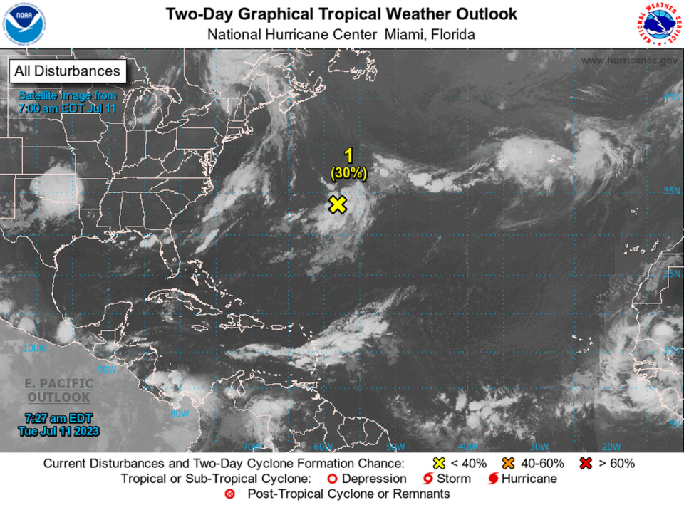
A trough of low pressure is also out there in the Atlantic a few hundred miles east-northeast of Bermuda. The system has a 30% chance of development in 48 hours and 50% chance over seven days, according to the National Hurricane Center’s 8 a.m. Tuesday advisory.
Tropical depression may form in Atlantic this week. What hurricane center forecast says

