Inside track on Potential Tropical Cyclone 13 with 3 weeks till storm strike odds shift | WeatherTiger
Three more weeks. More or less.
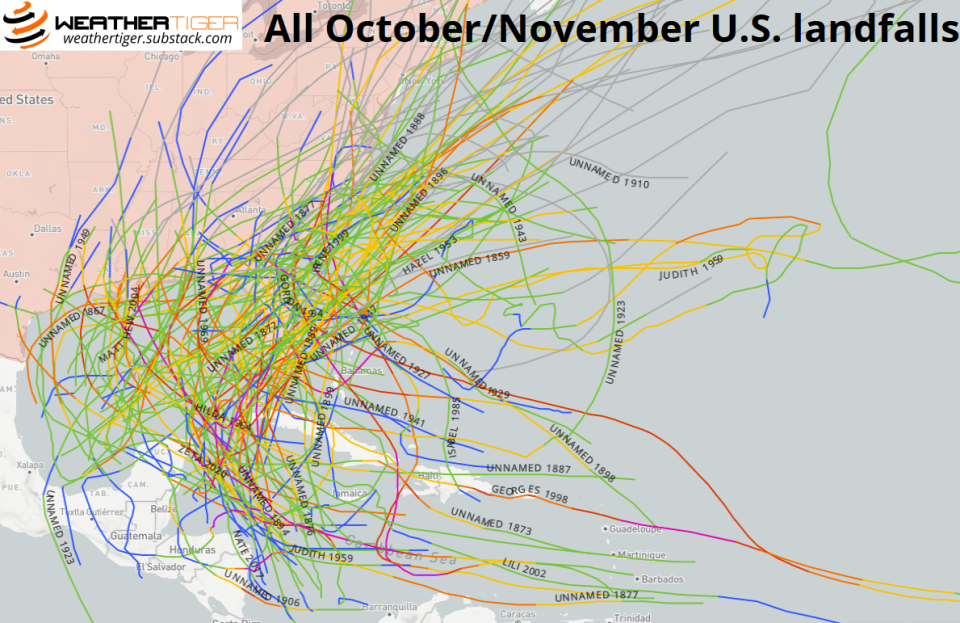
While hurricane season formally ends on Nov. 30, 97% of continental U.S. and Florida landfall activity occurs prior to Oct. 28 — also the latest date of a Category 3 or higher strike.
U.S. hurricanes are over 15 times and U.S. tropical storms five times more common in October than in November. A hurricane landfall occurs in around one-third of Octobers, with the Florida Gulf Coast and Keys the most frequent targets.
So while storms like 1985’s Hurricane Kate show the late-season odds of November tropical trouble are non-zero, there are three more weeks before the historical rates of U.S. landfalls fall off a cliff. More or less.
After Ian, the winds are in our favor; Potential Tropical Cyclone 13 is born
The good news is that as Florida attempts to dry off and dig out from what is likely the most destructive hurricane in state history, at least the first of those three weeks will pass without incident, and the outlook for the second is cautiously optimistic.
The Tropics are not calm in the wake of Ian’s wrath, but the jet stream pattern is such that the Gulf Coast is not in the line of fire for the first half of October.
The focus in the upcoming week is on Invest 91L, a tropical wave crossing the southern Lesser Antilles on Wednesday, which was upgraded Thursday morning to Potential Tropical Cyclone 13. This disturbance is generating a good deal of convection around a broad area of low-level turning, and will scrape the northern coast of South America through Friday while moving westward. Over the weekend, PTC-13 will leave land interaction behind and move into a favorable outflow environment over the western Caribbean, and the development of a tropical storm is expected.
Tropics watch: Tropical Depression 12 forms in Atlantic. Wave nearing Caribbean shows signs of strengthening

One eerie similarity to Ian, but major differences
If this sounds eerily familiar, that’s because the last paragraph could also have applied to proto-Ian two weeks ago. The major difference between PTC-13 and what became Ian are the steering winds out ahead of this disturbance. While there remains a trough over the eastern U.S., unlike during Ian, the southern edge of that dip in the jet stream will not extend south to Florida by the weekend.
Instead, subtropical high pressure will be in place over the Gulf of Mexico and western Atlantic into late next week.
The clockwise steering winds around this ridge will prevent any Ian-like turn north towards the U.S., and keep PTC-13 hustling westward into Belize, Honduras, or Nicaragua by Monday. If the storm bears more west-northwest and spends a bit longer over water, it may attain hurricane strength prior to reaching Central America.

Post-landfall, the system is expected to keep moving west and either cross into the eastern Pacific or wash out over the mountains of Central America. There is a slight chance of the system reaching the extreme southern Gulf of Mexico by next Wednesday. It is theoretically possible that a weakening of the Gulf ridging towards the end of next week could open the door for anything left of the storm to start sloshing back east or northeast around that time.
However, the most likely outcome is that the potential tropical cyclone is long gone by then, and there is no threat to the U.S. at this time. I’ll be keeping an eye on it just in case.
Tropical Depression 12 fizzling with a clear five to seven days ahead
Also out there — and I mean way out there — is Tropical Depression 12. This system only made it a few hundred miles west of the Cape Verde Islands before being hoovered north out of the Main Development Region, and is no threat to any populated landmass. TD 12 will be sheared out of existence by Thursday, though it may have an opportunity to redevelop early next week well east of Bermuda.
Otherwise, the Tropics are quiet, and nothing else is expected to develop in the next five to seven days. As October rolls around, the overwhelming majority of storms that eventually strike the continental U.S. originate in either the Gulf or Mexico or western Caribbean, so our focus leaves the Cape Verde region and tightens closer to home.
Florida isn't in the clear yet
Unfortunately, there are some signs that the environment there may be a little more favorable than usual for tropical activity this October and November.
Not only does the western Caribbean remain much warmer than average, but an ongoing moderate La Niña is likely to keep fall wind shear below average in these areas as well.
Climatologically, hurricane seasons with an ongoing La Niña have around 50% more Accumulated Cyclone Energy (ACE) and major hurricane activity after Oct. 5 than those that do not.
Putting it all together, WeatherTiger’s real-time model is projecting another 15-40 ACE units this season, likely more than the average 20 ACE units tallied from this point onward.
These numbers are updated daily on our website, so follow along as the days of hurricane season dwindle down to a precious few.
To close, Hurricane Ian shows that there are more things in heaven and earth than are dreamt of in climatology. Cataclysms without precedent can and do happen; rare, destructive events may not be as rare as we had assumed.
Entering the final 20% of hurricane season, getting through each week significantly improves the odds Florida can escape the year without additional punishment, but the season is far from over.
Keep watching the skies.
Who is WeatheTiger: Hurricane expert Ryan Truchelut provides Florida storm forecasts, analyses

Dr. Ryan Truchelut is chief meteorologist at WeatherTiger, a Tallahassee start-up providing forensic meteorology and expert witness consulting services, and agricultural and hurricane forecasting subscriptions. Get in touch at ryan@weathertiger.com, and visit weathertiger.com for an enhanced, real-time version of our seasonal outlook.
Never miss a story: Subscribe to the Tallahassee Democrat using the link at the top of the page.
This article originally appeared on Tallahassee Democrat: Florida October hurricane forecast: After Ian beating, it's a countdown

