More than 800,000 without power in California as intense atmospheric river brings threat of mudslides and flooding
An intense, long-lasting atmospheric river is moving into California Sunday, bringing the potential for “life-threatening” flooding, mudslides and widespread power outages as it dumps heavy rain and snow. Follow our live coverage here. This is what’s happening:
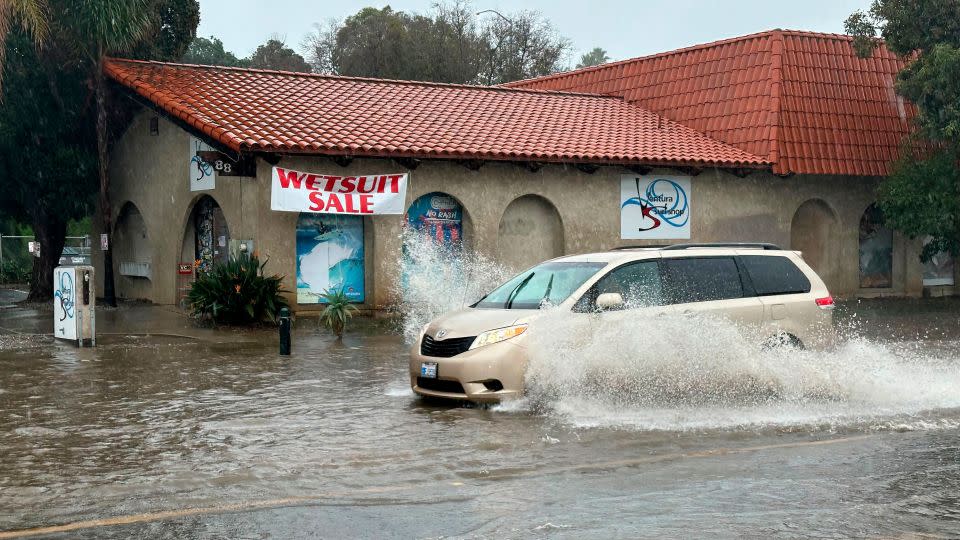
• Rare high risk for flooding: A rare Level 4 of 4 risk of excessive rainfall was expanded Sunday to include Los Angeles, in addition to Santa Barbara and Oxnard in Southern California, with the weather prediction center warning of “life threatening flash and urban flash flooding.” Rainfall rates up to an inch per hour will bring 3 to 6 inches of rain across the area. A more widespread Level 3 risk exists for much of coastal California, including San Francisco.
• A month’s worth of rain possible in Los Angeles: In Central and Southern California, widespread rainfall totals of 3 to 6 inches are expected – more than a month’s worth of rain for most. There are indications the storm may be as strong as Tropical Storm Hilary from last August, Los Angeles Mayor Karen Bass said during a news conference Friday, and encouraged residents to take “common sense precautions.”
• Some residents told to evacuate: Mandatory evacuation orders have been issued for communities in Santa Barbara, San José, Los Angeles and Ventura County. Officials warned residents of potential “life-threatening” floods and landslides from the atmospheric event. Several school districts in Santa Barbara County have also canceled classes on Monday due to the severe weather.
• First ever hurricane force wind warning: The National Weather Service in San Francisco on Sunday issued its first ever hurricane force wind warning since records have been kept. Widespread winds of 40 to 60 mph are expected throughout the state, with some gusts as high as 95 mph in the foothills and mountains. Wind advisories and high wind warnings are in effect for nearly 30 million people in inland areas across nearly the entire state from Redding to San Diego.
• “Near impossible” travel in the mountains: The storm is also expected to bring significant snowfall totals in eastern California and along the Nevada border. Heavy wet snow will spread across the Sierra Nevada through Monday with accumulation rates of 2 to 3 inches per hour, according to the weather service. Dangerous wind gusts are expected to produce whiteout conditions making travel above 5000-6000 feet “near impossible,” the weather service said.
• Power outages growing: More than 800,000 customers are without power in California, according to the tracking website PowerOutage.us, with outages rapidly rising, particularly along the coast, as rain and strong winds move in. The blackouts are expected to increase, especially in central and southern portions of California as wind gusts get stronger throughout the evening and into tomorrow.
• Rain and wind cause flight delays: At least 143 flights into, and 122 flights out of San Francisco International Airport have been delayed, according to the tracking website FlightAware. At least 100 flights were cancelled Sunday.
• Sporting events affected: Both NASCAR and PGA canceled events scheduled in California over the weekend due to the severe weather. NASCAR moved the Busch Light Clash at the Los Angeles Memorial Coliseum from Sunday to Saturday night, and the PGA Tour announced it would postpone Sunday’s final round of the Pebble Beach Pro-Am golf tournament, to Monday.
State braces for flooded roadways and swollen rivers
This atmospheric river – a long, narrow moisture band that carries saturated air thousands of miles then discharges it like a fire hose – comes right on the heels of another storm that brought record rainfall to most of California, including Los Angeles.
But this storm is much slower and is expected to stall as it moves onshore, bringing a much longer duration of rain compared to the first.
The worst of the storm will fall between Sunday and Tuesday, according to the weather service.
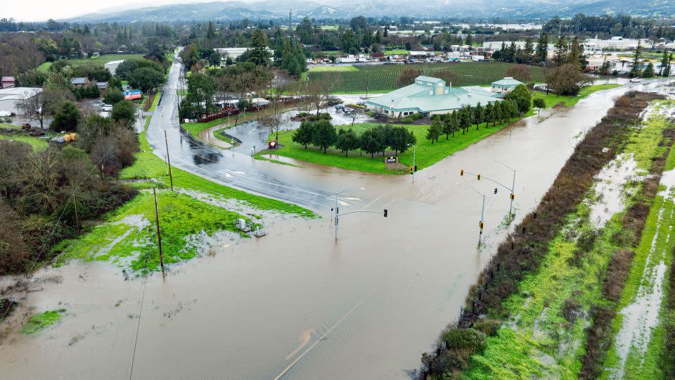
Parts of the central and southern coastline of the state are expected to see the most significant amounts of rain and flooding. This includes the Los Angeles and San Diego metro areas.
Combined with the 2.49 inches that fell in Los Angeles on Thursday, the city could potentially receive almost a year’s worth of rain in the first week of February alone.
“This damaging flooding will be a threat to lives and property,” Eric Schoening with the National Weather Service said at a news briefing Saturday. “Please, if you come across a flooded roadway, we urge you to turn around, don’t drown.”
Many roads could flood and there could be major rises on creeks, streams and rivers, as well as mud and rock slides and debris flows, Schoening added.
Already Sunday, the National Weather Service in San Francisco reported a landslide in the city. And in Santa Barbara more than 300 miles south, the storm triggered “extremely high winds,” flooding and toppled trees, Santa Barbara Police Department Sgt. Ethan Ragsdale told CNN.
At least 8 inches of rain can fall in less than 24 hours in parts of the Transverse Ranges in Southern California, with over 10 inches possible in some areas, the prediction center cautioned.
California Gov. Gavin Newsom visited the state’s operations center in Mather on Sunday to receive an update on the latest weather forecasts and the state’s response efforts.
Newsom’s office announced Friday the state has 1,200 pieces of winter equipment available to remove snow and ice from roads, 21 swift water rescue teams on standby and California National Guard members ready to deploy rapidly. More than 7 million sandbags have been prepositioned and the state is prepared to provide shelter and food for more than 37,000 people.
Speaking on CNN Newsroom on Sunday, Tony Tavares, director of the California Department of Transportation, said his department is “coordinating across multiple state departments, regional and local agencies to ensure the safety of all Californians. This includes prepositioning over 4,000 personnel and storm equipment such as portable pumps and generators across the state,” Tavares said.
Tavares described the department’s efforts as “all hands on deck,” as some crews in Northern California monitor wildfire burn scar areas, others deal with the snow and ice in the mountains, and crews along the southern coast watch for heavy flooding.
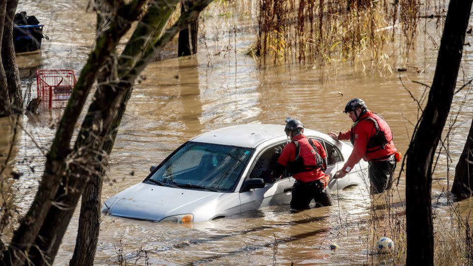
More than 8,500 personnel, including swift water and helicopter rescue teams, have been deployed statewide to respond to any potential calls for help, said Nancy Ward, director of the California Governor’s Office of Emergency Services.
“These next storms are going to be impactful and dangerous,” Ward said at a news briefing Saturday. “They’re the most dangerous natural disasters that we have, killing more people from storm damages and flooding than wildfires every year.”
The impact from powerful onshore winds will be felt across northern and central California through Sunday, eventually shifting to southern California into Sunday night, the National Weather Service said.
Wind advisories and high wind warnings stretch across pretty much the entire state of California from Redding down through San Diego affecting nearly 30 million people.
CNN meteorologists Allison Chinchar, Caitlin Kaiser, Sara Tonks and Elisa Raffa contributed to this report.
For more CNN news and newsletters create an account at CNN.com

