Intense thunderstorms ahead of cold front moving across portions of Florida
1/23 at 2am - A cold front continues to move southward across Central Florida this morning. As this front arrives in our area later this morning into the early afternoon hours, a few showers and perhaps an isolated thunderstorm is possible. #flwx pic.twitter.com/fCV4yLVv84
— NWS Miami (@NWSMiami) January 23, 2023
Intense thunderstorms are moving through Central and Southwest Florida this morning, bringing frequent lightning and very heavy rainfall.
It's just a hint of things to come for Florida during the week, including slightly lower temperatures today behind the front and even lower temperatures by Friday across much of the state.
The Storm Prediction Center said there is a marginal risk of severe thunderstorms Wednesday across parts of northern Florida and central and southern Georgia. The threat includes damaging wind gusts and tornadoes.
Tuesday evening, severe weather could stretch into Pensacola as storms move out of northern Mexico into the U.S., bringing moisture from the Gulf of Mexico. As the storms move east into Florida, threats for the western Panhandle include tornadoes, flooding rainfall and wind ups of 50 to 60 mph, according to AccuWeather forecasters. The strongest storms could hold wind gusts up to 75 mph.
The threat of strong thunderstorms will shift east into Georgia and northern Florida by Wednesday morning. Thunderstorms will continue to push onward along the Southeast coast into Wednesday evening, bringing heavy rainfall and the risk for travel disruptions as far as North Carolina.
Life or death:On the high seas between Florida and Cuba, U.S. immigration policy a matter of life and death
Wednesday's threats across most of the Panhandle and North Florida include heavy rain, isolated tornadoes and wind gusts up to 60 mph.
Weather radar, forecast for Pensacola

Follow National Weather Service Mobile on Twitter
Monday: Showers likely and possibly a thunderstorm before 10 a.m., then a chance of showers and thunderstorms between 10 a.m. and 1 p.m. Mostly cloudy, with a high near 72. South southwest wind 10 to 15 mph becoming north in the afternoon. Winds could gust as high as 20 mph. Chance of precipitation is 60%. New rainfall amounts between a tenth and quarter of an inch, except higher amounts possible in thunderstorms.
Monday night: Partly cloudy, with a low around 57. North wind around 10 mph.
Tuesday: Partly sunny, with a high near 74. East wind around 10 mph.
Tuesday night: Mostly cloudy, with a low around 65. Southeast wind 10 to 15 mph.
Wednesday: Partly sunny, with a high near 83. South wind 10 to 15 mph, with gusts as high as 20 mph.
Wednesday night: A 30 percent chance of showers and thunderstorms. Mostly cloudy, with a low around 59. South southwest wind 10 to 15 mph.
Thursday: Partly sunny, with a high near 71. North northwest wind 10 to 15 mph.
Thursday night: Partly cloudy, with a low around 47. North northwest wind 10 to 15 mph.
Friday: Mostly sunny, with a high near 65. North wind around 15 mph, with gusts as high as 20 mph.
Friday night: Mostly clear, with a low around 50. North northwest wind around 10 mph.
Saturday: Sunny, with a high near 69. North northeast wind 10 to 15 mph.
Saturday night: Partly cloudy, with a low around 59. East northeast wind around 10 mph.
Sunday: Partly sunny, with a high near 76. East southeast wind 10 to 15 mph, with gusts as high as 20 mph.
Weather radar, forecast for Tallahassee

Follow the National Weather Service Tallahassee on Twitter
Monday: Sunny, with a high near 59. North northwest wind 5 to 10 mph.
Monday night: Mostly clear, with a low around 37. North wind around 5 mph.
Tuesday: Mostly sunny, with a high near 64. East wind 5 to 10 mph.
Tuesday night: A 40 percent chance of showers and thunderstorms after 1am. Mostly cloudy, with a temperature falling to near 54 by 8pm, then rising to around 63 during the remainder of the night. Breezy, with an east wind 10 to 15 mph becoming south southeast 15 to 20 mph after midnight. Winds could gust as high as 30 mph.
Wednesday: Showers and possibly a thunderstorm before 1pm, then showers and thunderstorms likely after 1pm. High near 70. Breezy, with a south wind 15 to 20 mph becoming west southwest in the afternoon. Winds could gust as high as 35 mph. Chance of precipitation is 90%.
Wednesday night: Partly cloudy, with a low around 40.
Thursday: Sunny, with a high near 56.
Thursday night: Mostly clear, with a low around 36.
Friday: Sunny, with a high near 56.
Friday night: Mostly clear, with a low around 36.
Saturday: Sunny, with a high near 61.
Saturday night: Partly cloudy, with a low around 42.
Sunday: A 20 percent chance of rain. Mostly cloudy, with a high near 65.
Weather radar, forecast for Jacksonville

Follow the National Weather Service Jacksonville on Twitter
Monday: Sunny, with a high near 63. Breezy, with a northwest wind 10 to 15 mph.
Monday night: Mostly clear, with a low around 42. North wind 6 to 8 mph.
Tuesday: Mostly sunny, with a high near 67. North wind 6 to 10 mph becoming east in the afternoon.
Tuesday night: Mostly cloudy, with a low around 56. East wind 8 to 14 mph becoming southeast after midnight.
Wednesday: A 50 percent chance of showers after 1 p.m. Mostly cloudy, with a high near 80. Windy, with a south wind 17 to 24 mph, with gusts as high as 34 mph.
Wednesday night: A 40 percent chance of showers before 1 a.m. Mostly cloudy, with a low around 44. Windy.
Thursday: Mostly sunny, with a high near 59. Breezy.
Thursday night: Mostly clear, with a low around 38.
Friday: Sunny, with a high near 58.
Friday night: Mostly clear, with a low around 37.
Saturday: Sunny, with a high near 61.
Saturday night: Partly cloudy, with a low around 45.
Sunday: A 20 percent chance of showers. Mostly cloudy, with a high near 72.
Intense thunderstorms are ongoing in southwest Florida, with frequent lightning and very heavy rainfall. Track the storms here: https://t.co/v4RvdxVOxn pic.twitter.com/gGSEzdiCmz
— Breaking Weather by AccuWeather (@breakingweather) January 23, 2023
Weather radar, forecast for Daytona Beach
Follow the National Weather Service Melbourne on Twitter
Monday: Sunny, with a high near 63. Breezy, with a northwest wind 10 to 15 mph.
Monday night: Mostly clear, with a low around 42. North wind 6 to 8 mph.
Tuesday: Mostly sunny, with a high near 67. North wind 6 to 10 mph becoming east in the afternoon.
Tuesday night: Mostly cloudy, with a low around 56. East wind 8 to 14 mph becoming southeast after midnight.
Wednesday: A 50 percent chance of showers after 1 p.m. Mostly cloudy, with a high near 80. Windy, with a south wind 17 to 24 mph, with gusts as high as 34 mph.
Wednesday night: A 40 percent chance of showers before 1 a.m. Mostly cloudy, with a low around 44. Windy.
Thursday: Mostly sunny, with a high near 59. Breezy.
Thursday night: Mostly clear, with a low around 38.
Friday: Sunny, with a high near 58.
Friday night: Mostly clear, with a low around 37.
Saturday: Sunny, with a high near 61.
Saturday night: Partly cloudy, with a low around 45.
Sunday: A 20 percent chance of showers. Mostly cloudy, with a high near 72.
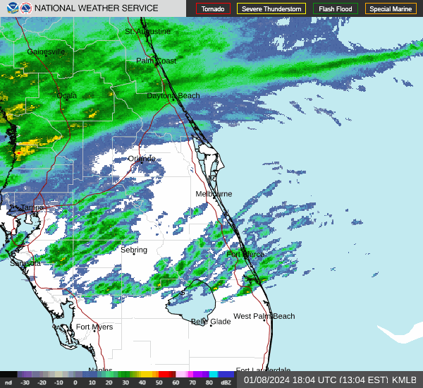
Weather radar, forecast for Melbourne
Follow the National Weather Service Melbourne on Twitter
Monday: A 50 percent chance of showers and thunderstorms before 10 a.m. Partly sunny, with a high near 71. West southwest wind around 10 mph becoming north in the afternoon. New precipitation amounts of less than a tenth of an inch, except higher amounts possible in thunderstorms.
Monday night: Partly cloudy, with a low around 56. North wind around 10 mph.
Tuesday: Mostly sunny, with a high near 73. East wind around 10 mph.
Tuesday night: Mostly cloudy, with a low around 65. East southeast wind around 10 mph.
Wednesday: Partly sunny, with a high near 83. South southeast wind 10 to 15 mph, with gusts as high as 20 mph.
Wednesday night: A 40 percent chance of showers and thunderstorms. Mostly cloudy, with a low around 58. South southwest wind around 15 mph, with gusts as high as 20 mph.
Thursday: Mostly sunny, with a high near 69. Northwest wind 10 to 15 mph, with gusts as high as 20 mph.
Thursday night: Mostly clear, with a low around 47. Northwest wind 10 to 15 mph.
Friday: Sunny, with a high near 64. North wind around 15 mph, with gusts as high as 20 mph.
Friday night: Mostly clear, with a low around 50. North northwest wind around 10 mph.
Saturday: Sunny, with a high near 68. North northeast wind 10 to 15 mph.
Saturday night: Partly cloudy, with a low around 58. East wind around 10 mph.
Sunday: Partly sunny, with a high near 76. East southeast wind 10 to 15 mph.
Weather radar, forecast for Port St. Lucie
Follow the National Weather Service Melbourne on Twitter
Monday: A 50 percent chance of showers and thunderstorms before 10 a.m. Partly sunny, with a high near 71. West southwest wind around 10 mph becoming north in the afternoon. New precipitation amounts of less than a tenth of an inch, except higher amounts possible in thunderstorms.
Monday night: Partly cloudy, with a low around 56. North wind around 10 mph.
Tuesday: Mostly sunny, with a high near 73. East wind around 10 mph.
Tuesday Night: Mostly cloudy, with a low around 65. East southeast wind around 10 mph.
Wednesday: Partly sunny, with a high near 83. South southeast wind 10 to 15 mph, with gusts as high as 20 mph.
Wednesday Night: A 40 percent chance of showers and thunderstorms. Mostly cloudy, with a low around 58. South southwest wind around 15 mph, with gusts as high as 20 mph.
Thursday: Mostly sunny, with a high near 69. Northwest wind 10 to 15 mph, with gusts as high as 20 mph.
Thursday Night: Mostly clear, with a low around 47. Northwest wind 10 to 15 mph.
Friday: Sunny, with a high near 64. North wind around 15 mph, with gusts as high as 20 mph.
Friday Night: Mostly clear, with a low around 50. North northwest wind around 10 mph.
Saturday: Sunny, with a high near 68. North northeast wind 10 to 15 mph.
Saturday Night: Partly cloudy, with a low around 58. East wind around 10 mph.
Sunday: Partly sunny, with a high near 76. East southeast wind 10 to 15 mph.
Weather radar, forecast for West Palm Beach

Follow the National Weather Service Miami on Twitter
Monday: A 30 percent chance of showers, mainly before 2 p.m. Patchy fog before 8 a.m. Otherwise, partly sunny, with a high near 80. South wind 9 to 13 mph becoming northwest in the afternoon. Winds could gust as high as 18 mph.
Monday night: Mostly cloudy, with a low around 61. North wind 9 to 11 mph.
Tuesday: Partly sunny, with a high near 75. East wind 9 to 11 mph.
Tuesday night: Mostly cloudy, with a low around 66. East wind around 10 mph.
Wednesday: Partly sunny, with a high near 86. Breezy, with a south wind 8 to 16 mph, with gusts as high as 25 mph.
Wednesday night: A 20 percent chance of showers after 1am. Partly cloudy, with a low around 64. South wind 8 to 10 mph.
Thursday: Mostly cloudy, with a high near 74. West wind 8 to 11 mph becoming north in the afternoon.
Thursday night: Partly cloudy, with a low around 48. North wind 10 to 13 mph, with gusts as high as 20 mph.
Friday: Mostly sunny, with a high near 69. North wind 11 to 14 mph, with gusts as high as 20 mph.
Friday night: Partly cloudy, with a low around 50.
Saturday: Sunny, with a high near 73.
Saturday night: Partly cloudy, with a low around 58.
Sunday: Partly sunny, with a high near 78.
Weather radar, forecast for Naples
Follow the National Weather Service Miami on Twitter
Monday: Showers and thunderstorms likely before 11 a.m., then a chance of showers between 11 a.m. and 1 p.m. Partly sunny, with a high near 73. Southwest wind around 10 mph becoming north in the afternoon. Chance of precipitation is 60%. New precipitation amounts of less than a tenth of an inch, except higher amounts possible in thunderstorms.
Monday night: Partly cloudy, with a low around 60. Northeast wind 10 to 14 mph, with gusts as high as 21 mph.
Tuesday: Partly sunny, with a high near 78. Northeast wind 10 to 13 mph, with gusts as high as 20 mph.
Tuesday night: Partly cloudy, with a low around 66. East wind around 10 mph.
Wednesday: Sunny, with a high near 79. South wind 10 to 15 mph, with gusts as high as 23 mph.
Wednesday night: A 30 percent chance of showers after 1 a.m. Partly cloudy, with a low around 63. South wind 7 to 9 mph becoming northwest after midnight.
Thursday: Partly sunny, with a high near 71. North wind 9 to 15 mph, with gusts as high as 23 mph.
Thursday night: Partly cloudy, with a low around 50. Breezy, with a north wind around 16 mph, with gusts as high as 23 mph.
Friday: Mostly sunny, with a high near 68. North wind 13 to 15 mph, with gusts as high as 23 mph.
Friday night: Partly cloudy, with a low around 51.
Saturday: Sunny, with a high near 73.
Saturday night: Mostly clear, with a low around 59.
Sunday: Mostly sunny, with a high near 78.
Weather radar, forecast for Fort Myers

Follow the National Weather Service Tampa Bay on Twitter
Monday: Showers likely and possibly a thunderstorm before 10 a.m., then a chance of showers and thunderstorms between 10 a.m. and 1 p.m. Partly sunny, with a high near 72. West northwest wind around 9 mph becoming north in the afternoon. Chance of precipitation is 60%. New rainfall amounts between a quarter and half of an inch possible.
Monday night: Partly cloudy, with a low around 57. Northeast wind 8 to 11 mph, with gusts as high as 18 mph.
Tuesday: Partly sunny, with a high near 78. East wind 9 to 11 mph.
Tuesday night: Partly cloudy, with a low around 66. East wind around 11 mph, with gusts as high as 18 mph.
Wednesday: Mostly sunny, with a high near 81. Breezy, with a southeast wind 10 to 17 mph becoming south southwest in the afternoon. Winds could gust as high as 26 mph.
Wednesday night: A 40 percent chance of showers and thunderstorms, mainly after 1am. Mostly cloudy, with a low around 63. South southwest wind 10 to 13 mph becoming west northwest after midnight. Winds could gust as high as 18 mph.
Thursday: Partly sunny, with a high near 70. North northwest wind 10 to 13 mph, with gusts as high as 18 mph.
Thursday night: Mostly clear, with a low around 48. North wind around 14 mph, with gusts as high as 21 mph.
Friday: Sunny, with a high near 66. North wind 11 to 14 mph, with gusts as high as 21 mph.
Friday night: Mostly clear, with a low around 48.
Saturday: Sunny, with a high near 72.
Saturday night: Mostly clear, with a low around 56.
Sunday: Mostly sunny, with a high near 80.
Weather radar, forecast for Sarasota
Follow the National Weather Service Tampa Bay on Twitter
Monday: Mostly cloudy, then gradually becoming sunny, with a high near 70. North wind 11 to 14 mph, with gusts as high as 21 mph.
Monday night: Partly cloudy, with a low around 51. Northeast wind 10 to 14 mph, with gusts as high as 21 mph.
Tuesday: Mostly sunny, with a high near 78. East wind 10 to 14 mph, with gusts as high as 20 mph.
Tuesday night: Partly cloudy, with a low around 64. Breezy, with an east wind 10 to 15 mph, with gusts as high as 24 mph.
Wednesday: A 20 percent chance of showers and thunderstorms after 1 p.m. Mostly sunny, with a high near 79. Windy, with a south wind 15 to 21 mph, with gusts as high as 31 mph.
Wednesday night: Showers likely and possibly a thunderstorm before 1 a.m., then a chance of showers and thunderstorms after 1 a.m. Mostly cloudy, with a low around 58. Breezy, with a south southwest wind 10 to 16 mph becoming north northwest after midnight. Winds could gust as high as 24 mph. Chance of precipitation is 60%.
Thursday: Mostly sunny, with a high near 66. Breezy, with a north northwest wind 13 to 16 mph, with gusts as high as 23 mph.
Thursday night: Mostly clear, with a low around 47. Breezy, with a north wind 13 to 15 mph, with gusts as high as 23 mph.
Friday: Sunny, with a high near 63. North northeast wind around 14 mph, with gusts as high as 22 mph.
Friday night: Mostly clear, with a low around 46.
Saturday: Sunny, with a high near 69.
Saturday night: Partly cloudy, with a low around 54.
Sunday: Partly sunny, with a high near 77.
This article originally appeared on Treasure Coast Newspapers: Florida weather forecast, radar: Track storms, cold front
