National Hurricane Center reports Invest 91L has upgraded to Tropical Depression Two
The 2023 Atlantic hurricane season has officially arrived, and Florida residents are keeping a close eye on Tropical Depression Two, which formed in the Gulf of Mexico late Thursday afternoon, according to the National Hurricane Center.
June 1 marks the first day of the hurricane season, which runs until Nov. 30.
Tropical Depression Two is moving slowly over the northeastern Gulf of Mexico. The center is about 305 miles west-northwest of Fort Myers.
At its 5 p.m., advisory, the National Hurricane Center said maximum sustained winds are at 35 mph with higher gusts. It is expected to intensify and it could become a tropical storm Thursday night or Friday. However, the system should be short-lived.
Water temperatures in the Gulf of Mexico are high enough to support tropical development. Temperatures in the central and eastern Gulf range from the mid-70s to low 80s. For a tropical system to develop, temperatures need to be in the upper 70s or higher, according to AccuWeather.
CSU increases hurricane predictions: CSU updates hurricane season forecast, predicting 15 named storms, 7 hurricanes
NOAA's forecast: When is hurricane season? Here's when hurricane season starts and what to expect in 2023
WeatherTiger: 2023 hurricane season will be 'once-in-a-generation slugfest' between tropical forces
The first named storm of the season will be Arlene.
A sales tax holiday to help Florida residents purchase hurricane supplies runs through June 9. A second 14-day disaster preparedness tax holiday will run Aug. 26 through Sept. 8.
While the first named storm of the 2023 season will be Arlene, it will actually be the second storm of the season. A system in January was classified in May as a subtropical storm. Since the classification came during a post analysis, it did not get a name and will be documented as "Unnamed."
Here's the latest update from the NHC as of 5 p.m. June 1:
What's out there and where are they?
Invest 91L became Tropical Depression Two in the Gulf of Mexico and three tropical waves in the Atlantic basin, which includes the Atlantic, Caribbean Sea and Gulf of Mexico.
Tropical Depression Two: Maximum sustained winds are about 35 mph. Rainfall of 1-3 inches and possible rain of up to 6 inches is possible through the Florida peninsula.
Tropical wave 1: A tropical wave in the eastern Atlantic is located southeast of Cabo Verde west of Guinea. It's moving west at 17 mph. Exact location: 19W from 13N to 03N.
Tropical wave 2: A tropical wave in the central Atlantic is located northeast of French Guiana, east of Trinidad and Tobago. It's moving west at 11 mph. Exact location: 44W from 15N to 04N.
Tropical wave 3: Another tropical wave is located south of the Dominican Republic. The system is nearly stationary. Exact location: 69W from 18N to 09N.
What are chances for tropical development of system in Gulf of Mexico?
Environmental conditions remain marginally favorable for additional development, and if these trends continue, a short-lived tropical depression or storm is likely to form as soon as this afternoon.
The system is expected to meander over the northeastern Gulf of Mexico through tonight but begin a slow southward motion Friday.
By this weekend, environmental conditions are forecast to become unfavorable for additional development as the system continues moving south, likely remaining offshore over the Gulf of Mexico.
Who is likely to be impacted?
Regardless of development, locally heavy rainfall could occur over portions of the Florida Peninsula through this weekend, according to the Hurricane Center.
Drenching downpours and locally gusty thunderstorms will precede the storm's arrival, AccuWeather Senior Meteorologist Adam Douty said.
A flood watch is in effect for portions of Southeast and South Florida until Friday evening. The National Weather Service warned 2 to 4 inches of rain is possible over the next few days, with some areas possibly seeing more than 6 inches.
A flood advisory was issued by the National Weather Service for Brevard County Thursday morning, where 2 to 3.5 inches of rain had already fallen and another 1 to 2 inches expected.
Storms will continue through the end of the week, "with the bulk of the downpours and thunderstorms likely from Thursday to Saturday" over Florida," Douty said.
Florida impact: Storm front could bring 2-3 inches of rain to Sarasota and Manatee counties
"It is possible the storms may depart by the weekend, but that will depend on if there is a concise storm center versus a broad area of low pressure."
AccuWeather forecasters predicted 1 to 2 inches of rain will fall through Saturday across North Florida, with the southern half of the state receiving 2 to 4 inches. The exact amounts depend on the track and development of Invest 91L.
It's too early at this time to determine if there will be any impact to the Florida or the U.S. from the tropical waves.
Forecasters urge all residents to continue monitoring the tropics and to always be prepared.
Weather radar: Watch system in northeastern Gulf of Mexico

The National Weather Service office in Tampa Bay warned residents that tropical moisture will return for the rest of the week, with scattered showers and storms each afternoon and evening. Rainfall over the week could be 1 to 4 inches.
Miami's National Weather Service office also warned residents of the potential for locally heavy rainfall that could lead to street flooding. Some areas could get 1 to 3 inches of rain.
Record rainfall: Florida's rainfall record may soon fall. Current record is almost 2 feet over 24 hours
Florida's east coast can also expect rain as the system moves across the state.
The National Weather Service Melbourne said 1 to 2 inches could fall from Daytona Beach south to Stuart, with the heaviest rain to the south, which could get up to 4 inches.
Jim Cantore comments on Gulf system
Broadcast meteorologist with The Weather Channel, a personality Floridians keep a wary eye on during hurricane season, described the Gulf of Mexico system on Twitter Wednesday morning.
"The gulf is bubbling with broad twisting action."
The gulf is bubbling with broad twisting action...@CODMeteorology pic.twitter.com/vvn6a5aHb4
— Jim Cantore (@JimCantore) May 31, 2023
When does something become a tropical depression or tropical storm?
Both a tropical depression and tropical storm have a rotating, organized system of clouds and thunderstorms and a closed low-level circulation, according to NOAA.
Tropical depression: A tropical cyclone with maximum sustained winds of 38 mph or less.
Tropical storm: A tropical cyclone with maximum sustained winds of 39 to 73 mph.
Weather watches and warnings issued for your area
If you can't see any local weather warnings here, you'll need to open this story in a web browser.
When is the Atlantic hurricane season?
The Atlantic hurricane season runs from June 1 through Nov. 30.
When is the peak of hurricane season?
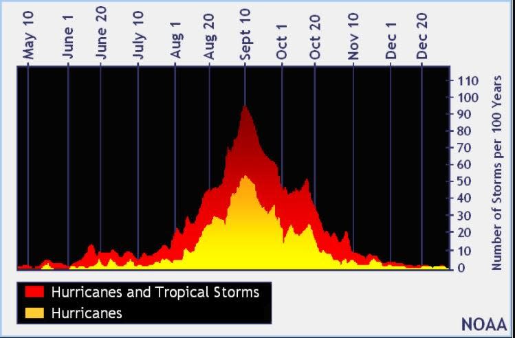
The peak of the season is Sept. 10, with the most activity happening between mid-August and mid-October, according to the Hurricane Center.
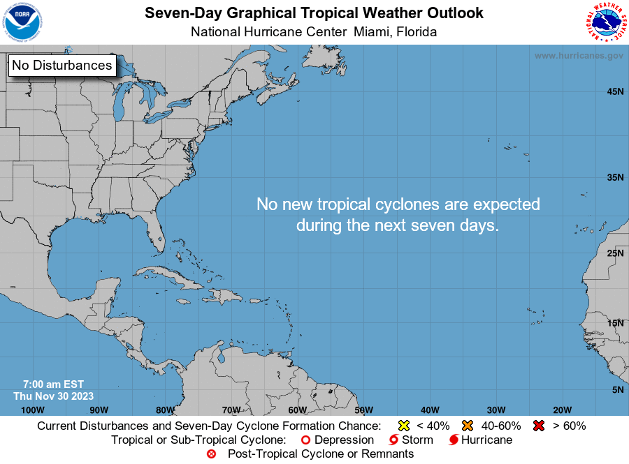
Tropical forecast over the next seven days
Excessive rainfall forecast
What's out there?
Systems currently being monitored by the National Hurricane Center.
What's next?
We will continue to update our tropical weather coverage daily. Download your local site's app to ensure you're always connected to the news. And look at our special subscription offers here.
This article originally appeared on Fort Myers News-Press: Tropics watch: Tropical depression forms in Gulf of Mexico

