Isaias Will Leave Florida As Tropical Storm: Hurricane Center
MIAMI, FL — Isaias strengthened slightly but was not expected to regain its prior stature as a category 1 hurricane Sunday and instead may be relegated to remain a tropical storm as it makes its way through Florida and up the U.S. East Coast.
That may be a good thing not only because Floridians were already coping with the coronavirus pandemic and its associated economic costs, but frankly because Isaias is just difficult to pronounce and the Sunshine State could use a break right now.
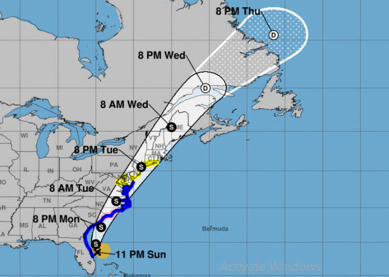
The National Hurricane Center reported in its 8 p.m. Sunday advisory that Isaias had maximum sustained winds of 70 mph. The storm was located 55 miles east-southeast of Cape Canaveral and 305 miles south of Myrtle Beach, South Carolina.
Isaias is expected tomake landfall in the Carolinas and move across the .U.S. mid-Atlantic region late Monday and Tuesday.
Forecasters dropped a hurricane warning along the east coast of Florida early Sunday but had a number of watches and warnings still in place.
"On the forecast track, the center of Isaias will pass just to the east of the Florida east coast through tonight," the National Hurricane Center said in its 11 p.m. Sunday advisory. "The center of Isaias will then move offshore of the coast of Georgia and southern South Carolina on Monday, move inland over eastern South Carolina or southern North Carolina Monday night and move along the coast of the mid-Atlantic states on Tuesday."
The National Hurricane Center said some fluctuation in storm strength was possible over the next 36 hours. Tropical-storm-force winds extend outward up to 115 miles from the center of the storm and can still cause damage and flooding, including serious damage to property.
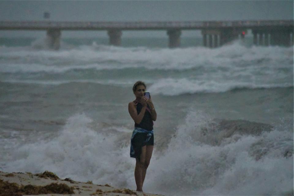
Isaias made its presence known in South Florida on Saturday while still a category 1 storm.
Skies darkened over Miami, winds howled, thunder rumbled and feeder bands from then Hurricane Isaias pelted areas of South Florida with quick bursts of rain.
“We just had our first feeder band,” Boca Raton resident Laura Tipka told Patch on Saturday. “It was fun. “The wind was blowing from side to side and it was raining sideways and windy, really windy. Now there’s nothing. The sun is out and the pavement is almost dry.”
The storm was downgraded back to a tropical storm late Saturday afternoon but the National Hurricane Center initially said Isaias would likely regain its strength as it crossed over the warmer waters around Florida, something that did not happen.
People ventured to the beaches to take selfies by the unusually rough seas around South Florida on Saturday.
Take in the view from Hurricane Hunter aircraft "Miss Piggy"as it investigates Isaias below:
CARIBBEAN - Inside flight station of NOAA WP-3D #NOAA43 Miss Piggy flying through the eyewall of Hurricane #Isaias during morning flight 080120. Credit Lt. Cmdr. Doremus, NOAA Corps. Follow @NHC_Atlantic for latest forecast and advisories. #FlyNOAA #MsPiggyFlies pic.twitter.com/TLnZaCj56V
— NOAA Aircraft Operations Center (@NOAA_HurrHunter) August 1, 2020
All three official Florida Welcome Centers transitioned to become emergency information centers on Saturday providing the latest details on the storm rather than the usual information about the Sunshine State's many attractions.
Watches And Warnings
A storm surge watch is in effect for Edisto Beach, South Carolina to Cape Fear, North Carolina
A storm surge watch is in effect for Cape Fear to Duck, North Carolina and Pamlico and Albemarle Sounds.
A hurricane watch is in effect for. South Santee River, South Carolina to Surf City, North Carolina.
A tropical storm warning is in effect for Sebastian Inlet Florida to Ocracoke Inlet, North Carolina.
A tropical storm watch is in effect for Ocracoke Inlet, North Carolina to Watch Hill, Rhode Island; Pamlico and Albemarle Sounds; Chesapeake Bay; Tidal Potomac River; Delaware Bay; Long Island and Long Island Sound.
Tropical storm warning means that tropical storm conditions are expected somewhere within the warning area, generally within 36 hours. Unlike the warning, a tropical storm watch means that tropical storm conditions are possible within the watch area within 48 hours.
See related:
Hurricane Isaias: Hurricane Shelters Adapt To Pandemic Protocols
Hurricane Isaias: Keeping Pets Comfortable During A Hurricane
Pinellas County Monitoring Potential Tropical Storm Isaias, Time To Prepare
St. Pete Testing Site Closes Ahead Of Tropical Storm Precaution
The following rainfall totals were possible along the U.S. East Coast:
Eastern Florida: 2 to 4 inches, with isolated maximum totals of 6 inches.
Northeast Florida and coastal Georgia: 1 to 3 inches.
Carolinas and the mid Atlantic: 3 to 5 inches, with isolated maximum totals of 7 inches.
Southeast New York and much of New England: 2 to 4 inches, with isolated maximum totals of 6 inches.
"Heavy rainfall from Isaias will continue to result in potentially life-threatening flash flooding in the Northwest Bahamas through tonight," the National Hurricane Center said at 11 p.m.. Sunday. "Flash and urban flooding, some of which may be significant in the eastern Carolinas and the Mid-Atlantic, is expected through midweek along and near the path of Isaias across the East Coast of the United States. Widespread minor to isolated moderate river flooding is possible across portions of the Carolinas and Mid-Atlantic."
The National Hurricane Center also warned of swells generated by Isaias and the potential for a few tornadoes along coastal South Carolina during Monday afternoon and evening, spreading across eastern North Carolina on Monday night.
This article originally appeared on the Miami Patch

