Jackson weather: High winds, large hail, tornadoes possible Sunday afternoon
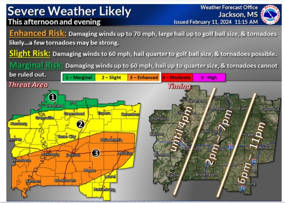
Central Mississippi has an enhanced risk for severe weather, including hail and damaging winds with the possibility of tornadoes Sunday afternoon, according to the National Weather Service.
The Jackson area is at risk from 2 p.m. to 7 p.m. with the potential for 70 mph winds and golf ball-sized hail.
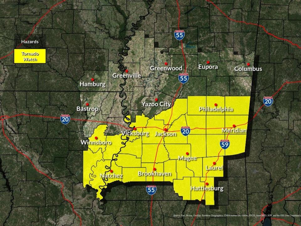
A tornado watch is in effect until 7 p.m. for the Jackson area including Hinds, Madison, Rankin, Warren and Copiah counties.
Storms should move through the Hattiesburg area after 6 p.m. The NWS categorizes the Hattiesburg area as a slight risk. The Mississippi Delta also falls into the slight-risk category, according to the NWS.
6 p.m.: Tornado Watch continues for 27 counties
The Jackson National Weather Service issued an alert stating counties in Mississippi are under watch until 7 p.m.
Central Mississippi: Copiah, Hinds, Leake, Madison, Rankin, Scott, Simpson and Smith
East Central Mississippi: Clarke, Jasper, Kemper, Lauderdale, Neshoba and Newton
South Central Mississippi: Jefferson Davis, Lawrence, Lincoln and Marion
Southeast Mississippi: Covington, Forrest, Jones and Lamar
Southwest Mississippi: Adams, Claiborne, Franklin and Jefferson
West Central Mississippi: Warren
4:50 p.m: Warning issued for central Hinds County
The National Weather Service in Jackson has issued a Serve Thunderstorm Warning for central Hinds County in central Mississippi until 5:45 p.m.
The service reported that at 4:48 p.m., a severe thunderstorm was located near Learned or 9 miles west of Raymond. The storm was moving northeast at 35 mph.
This severe thunderstorm will be near Raymond, Edwards and Bolton around 4:55 p.m. It will then be near Jackson around 5 p.m. Then, it will be near Clinton and Brownsville around 5:05 p.m and Pocahontas around 5:15 p.m.
The service said hail damage to vehicles is expected along with wind damage to roofs, siding and trees.
4:30 p.m.: More warnings issued
The National Weather Service in Jackson has issued a Severe Thunderstorm Warning for more areas of the state.
The following locations are under a warning until 5:15 p.m.:
Standing Pine
Hillsboro
Forkville
Walnut Grove
Winds are expected to reach up to 60 mph. Half-dollar-sized hail is possible.
The following areas are under a warning until 5:30 p.m.:
Quitman
Stonewall
Pachuta
Snell
Winds are expected to reach up to 60 mph. Quarter-sized hail is possible.
The following locations are listed under a warning until 5:45 p.m.:
Clinton
Raymond
Edwards
Winds are expected to reach up to 60 mph. Quarter-sized hail is possible.
4:05 p.m.: Tornado Watch expanded for some areas
The Jackson National Weather Service released a statement via social media stating the tornado watch across the area has been expanded to include the Pine Belt areas of southeast Mississippi.
The service said several counties and Parishes north of the I-20 corridor have been removed from the existing watch areas.
2:30 p.m.: Another Severe Thunderstorm Warning issued
The National Weather Service's Jackson office has issued a Severe Thunderstorm Watching for more areas of Mississippi.
The following locations are under a warning until 3:30 p.m.:
Carthage
Walnut Grove
Redwater
At 2:39 p.m., the service said severe thunderstorm warnings will continue for Kosciusko, Ethel and McCool until 3:15 p.m.
2:15 p.m.: Severe Thunderstorm Warning issued
Severe Thunderstorm Warnings are now in effect in some areas of the state, according to the National Weather Service office in Jackson.
The following areas are under a warning until 3:15 p.m.:
Kosciusko
Durant
Goodman
This is a developing story. Return to the Clarion Ledger for updates.
This article originally appeared on Mississippi Clarion Ledger: Jackson, MS, weather for Sunday, February 11. Tornadoes, hail possible

