Hazardous road conditions expected through Sunday morning for Jacksonville area
11 a.m. Saturday: Road conditions will remain hazardous through Sunday morning
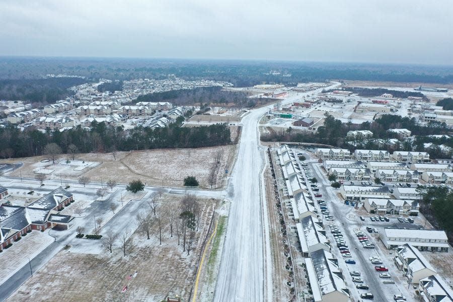
Ice from Winter Storm Jasper resulted in hazardous road conditions for Onslow County Friday and Saturday, and many roads may still be unsafe to travel on Sunday.
Many bridges and roadways were closed late Friday night into today due to the conditions.
As of 7:45 a.m. this morning, several hundred homes were without power in Swansboro and North Topsail Beach, and Onslow saw a quarter of an inch to a half an inch of ice across the county.
The National Weather Service wants people to know that although precipitation ended early this morning, roadways are likely to continue to pose danger Sunday following the low temperatures this evening which will result in refreezing.
"Substantial melting" is expected to come throughout Sunday, though, with highs in the mid-40s.
Roads will be “treacherous through Sunday morning due to sub-freezing temperatures,” the NWS said in a briefing this morning. Some churches, such as Verona United Methodist, have already canceled service for Sunday morning due to continued hazardous road conditions.
If you must travel, continue to proceed with caution. Otherwise, officials urge residents to wait until conditions improve.
This is the final live update from The Daily News on the weather conditions in Jacksonville. We will be monitoring conditions and share breaking news if it occurs.
- Morgan Starling
9 a.m. Saturday: Don't drive, it's not worth it
No matter how good of a driver you are, city and county officials are urging residents to stay home, and off the roads.
N.C. Department of Transportation posted Saturday morning, "we're happy to see roads pretty clear of vehicles this morning. Unless you're essential or there is an emergency, there is no reason to be driving today."
Jacksonville Public Safety agreed, adding that roads should be avoided if possible for not only your safety, but the safety of city crews, emergency personnel, and others who are working to clear roads and restore service.
Onslow County Government posted on Facebook that as of 7:45 a.m., there are several hundred homes without power in Swansboro and North Topsail Beach.
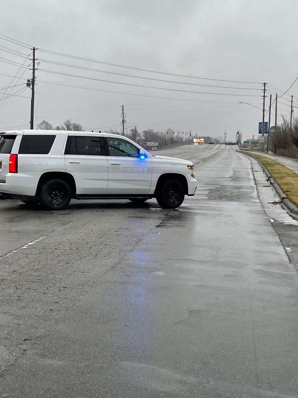
Additionally, the Lewis Sewell Bridge (Highway 17 Bypass), Camp Lejeune Main Gate Overpass (Highway 24), Read Gate Bridge to Base (Highway 172 in Sneads Ferry), and North Topsail Bridge (Highway 210) are officially closed.
"All bridges in Onslow County are hazardous to traverse, even the ones that aren’t closed to traffic."
Several accidents have occurred since last night, specifically on bridges.
Adding to the closures, the Onslow County Landfill is closed today due to the weather. The landfill and convenience sites will reopen on Monday, weather permitting.
- Morgan Starling
7:45 a.m. Saturday: Ice accumulation overnight causes additional danger
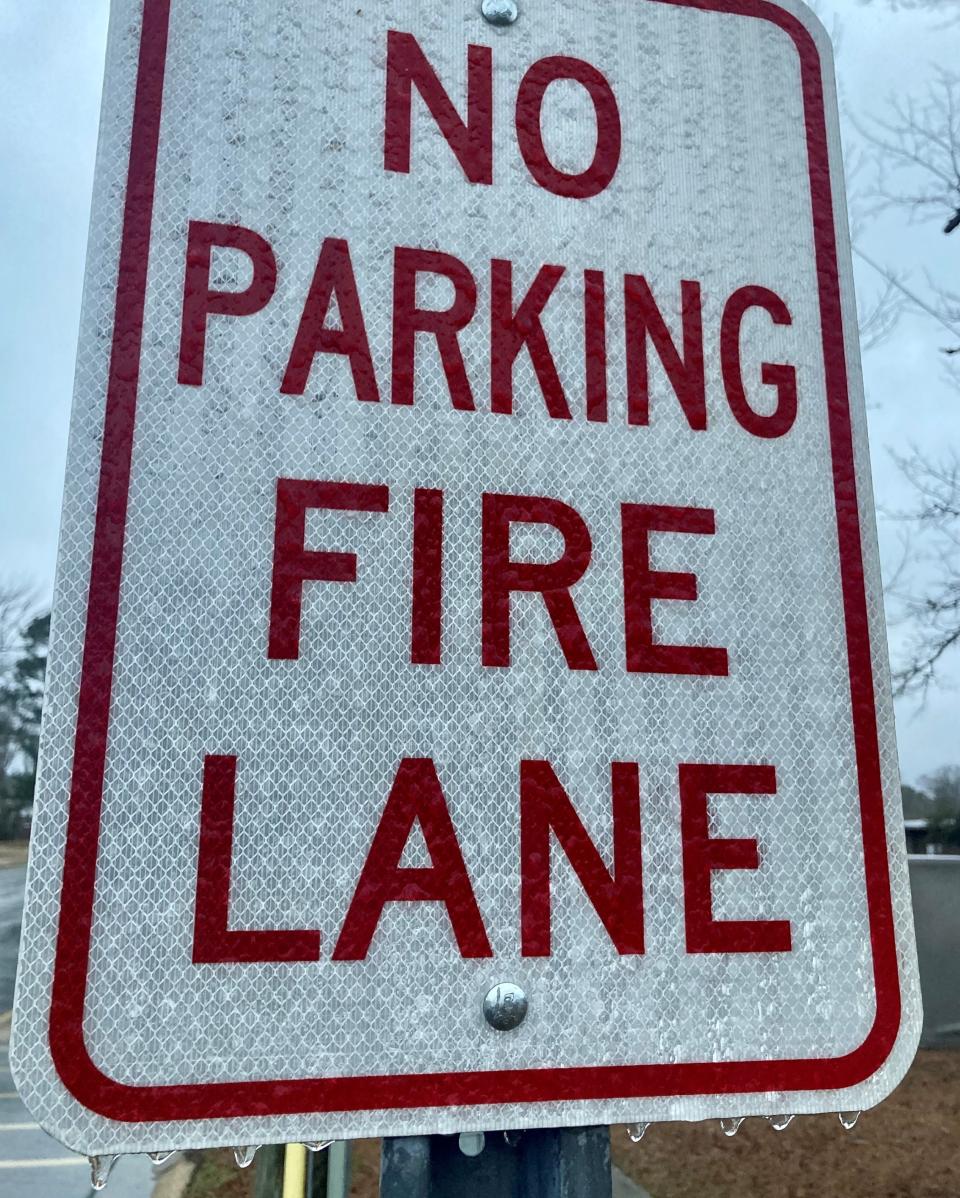
The Onslow area saw a significant amount of ice accumulation overnight, causing treacherous road conditions and scattered power outages.
National Weather Service Meteorologist Casey Dail said they've had reports of ice in Onslow County anywhere from a quarter of an inch to a half an inch as reports continue to come in.
Precipitation has ended, though there could still be a few lingering flurries for the next hour.
"The main concern moving forward today and into the first part of tomorrow is going to be hazardous travel conditions," said Dail. "There are roadways that are still covered in snow and/or sleet and ice. There will be some melting this afternoon, but anything that does melt is going to refreeze this evening and overnight."

Temperatures are expected to get above freezing today, but barely, and will return to below freezing into the evening and overnight, so traveling should be avoided if possible.
- Morgan Starling
7:45 p.m.: Storm sets in, travel ‘very dangerous’
The storm is here.
Freezing rain has resulted in multiple vehicle accidents in Jacksonville as officials across the region are begging people to stay off the roads.
“We are now receiving reports about roads freezing and traveling becoming very dangerous,” said NWS Newport/Morehead in a tweet. “Snow, sleet, and freezing rain continues to intensify this evening across the area.”
The precipitation is expected to continue overnight into early Saturday morning as Onslow County should continue to see freezing rain – and potentially snow and sleet – well past midnight.
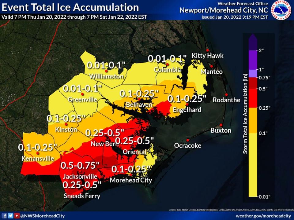
The National Weather Service predicts precipitation will be over by 7 a.m.; however, ice accumulations could reach half an inch or higher in the Onslow area with a likelihood of power outages.
A weather service briefing also says there will be “lingering impacts” to travel through the weekend due to cold temperatures at night with “substantial melting” expected to come on Sunday with highs in the mid-40s.
Roads will be “treacherous through Sunday morning due to sub-freezing temperatures,” the briefing said.
Area road closings are also being announced. The Jacksonville bypass has been closed due to icy conditions.
- Calvin Shomaker
6 p.m.: Jacksonville police report numerous crashes
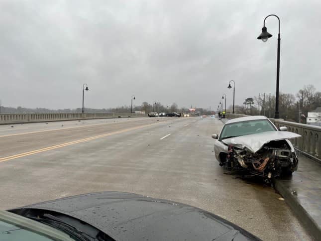
The Jacksonville Department of Public Safety is reporting multiple collisions that have come as a result of city bridges and roadways accumulating ice amid an increase in freezing rain.
In a Facebook post, the department has asked the public to stay home if they do not need to travel. According to the post, the North Carolina Department of Transportation is actively salting the roads.
Temperatures are expected to reach a low of around 24 in Jacksonville tonight, according to the National Weather Service. An ice storm warning is still in effect until 7 a.m. Saturday; however, roadways are likely to continue to pose danger to motorists as the weather service predicts a high of 37 on Saturday and a low of 19 Saturday night.
- Calvin Shomaker
4:30 p.m.: Conditions to ‘rapidly deteriorate’ in coming hours
The National Weather Service expects conditions to worsen fast Friday evening.
“Conditions will begin to rapidly deteriorate over the next few hours,” NWS Morehead City said in a tweet predicting an increase in the intensity of wintry precipitation across Eastern North Carolina.
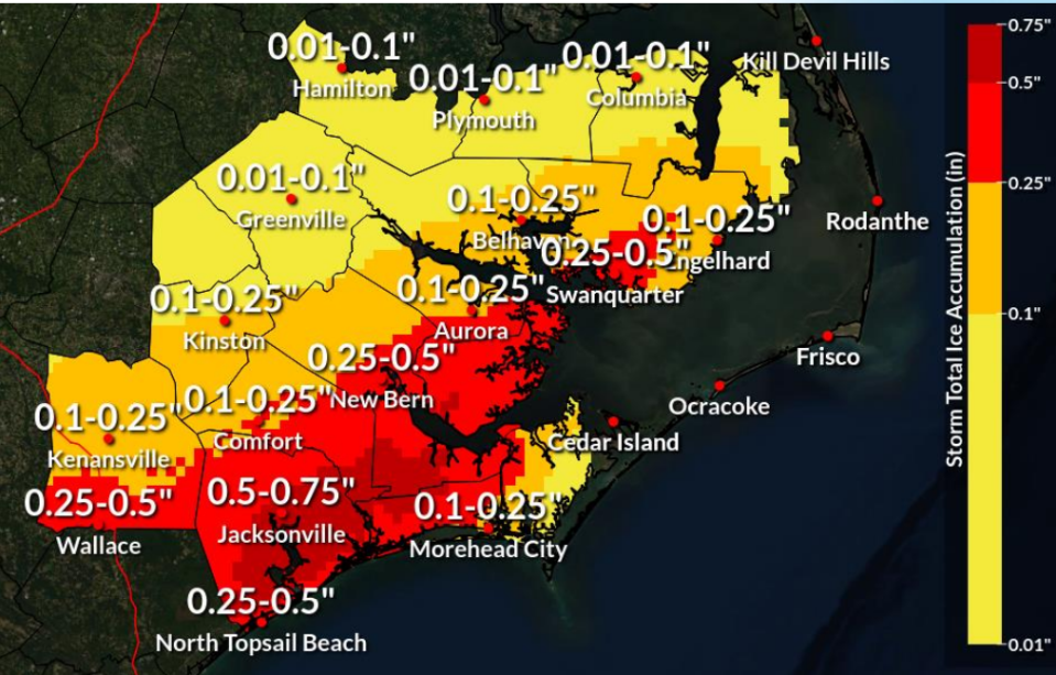
By 5 p.m., Onslow could experience snow, sleet and freezing rain, according to the latest weather service briefing, which says up to 0.75 inches of ice is possible through Saturday morning.
The City of Jacksonville streets division has been at work since 4 a.m. pretreating roads near city fire stations, the hospital and other areas of concern, according to Tory Miller, streets supervisor.
“We advise everyone to stay home as much as possible, because you run into the risk of black ice during the night,” Miller said.
The streets team will be active throughout the night and Saturday morning, .
Jacksonville residents concerned by downed trees in roadways may alert the city at 910-938-5333.
- Calvin Shomaker
3:15 p.m.: Storm approaching, residents advised to remain vigilant
The timing of the storm may be delayed from what was previously expected, but Onslow County Emergency Services Director Norman Bryson says it is still coming.
“Pretty much we are just watching and waiting on the storm at this point in time,” Bryson said. “We are still hearing that it’s coming and for people not to let their guard down.”
The forecast of 0.25 to 0.5 inches of ice in Onslow is still possible, according to Bryson, who emphasized that power outages need to be reported to the power company, not 911. Downed power lines due to car accidents and downed trees in the roadway do warrant 911 calls, Bryson said.
In Jacksonville, freezing rain is likely to ensue in the late afternoon hours and continue into the night, according to the the National Weather Service (NWS). After 1 a.m., the NWS is calling for sleet with wind gusts as high as 22 miles per hour.
- Calvin Shomaker
11:30 a.m.: Winter weather begins to worsen, Jacksonville Mall closed
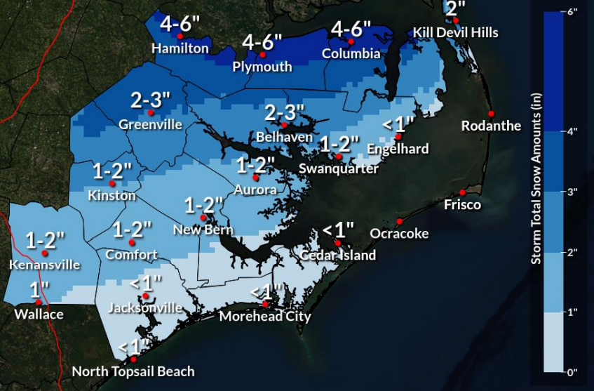
The National Weather Service is still reporting ice amounts up to a quarter inch for Jacksonville and Onslow County Friday evening through Saturday morning, amounts which could be historic and unprecedented for Onslow.
"Temperatures are kind of around 30 in Jacksonville and they're not going to go up from there," said NWS Meteorologist Erik Heden, "so they're just going to hold steady or slowly fall."
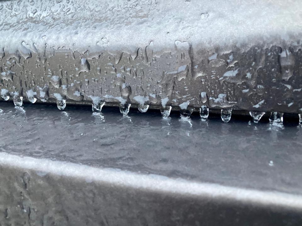
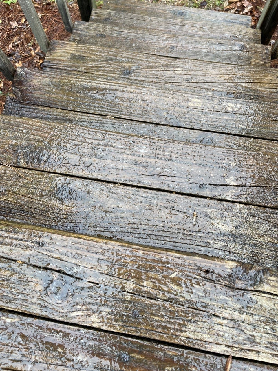
Heden said they're starting to see reports of freezing rain, which is sticking on elevated surfaces like cars and decks, but that soon the bridges and major roads will begin to ice over.
Temperatures are expected to quickly drop into the 20s beginning around sunset as conditions worsen into the night, according to Heden.
The NWS also said to expect winds at 20-25 mph, which will enhance icing and power outages.
Jacksonville Public Safety reported at 11:13 a.m. that roads were still fair and drivable, with weather conditions in the city at 29 degrees with a light drizzle. No weather-related accidents have been reported.
Additionally, Senior Marketing Director of the Jacksonville Mall, Mikia Ross announced the mall will be closed today due to the weather.
- Morgan Starling
10 a.m.: Try not to drive, but if you have to, here's how to do so safely
The N.C. Department of Transportation has crews ready to clear roads, but driving in this winter storm is still dangerous, and not recommended.
According to NCDOT, there are precautions that you should take before even getting into your vehicle.
These include making sure your vehicle is running well and equipped properly for driving on dangerous roads, which also means having at least a half-tank of gas in your vehicle regardless of the length of your commute. They also suggest keeping a supply kit handy that includes an ice scraper, snow brush, windshield wiper fluid, anti-freeze, and a basic automotive tool kit with jumper cables and flares.
It's also good to have a flashlight, first-aid kit, blanket, shovel, sand, non-perishable snacks, and drinking water.
When driving, NCDOT urges drivers to slow down and maintain a safe following distance, as well as passing with extreme caution. They said excessive speed is the No. 1 cause of wrecks in winter weather.
It is recommended not to use cruise control, not to apply brakes while on a bridge, and to treat intersections where traffic lights are out as a four-way stop.
"Most importantly is for everyone to limit travel to only essential trips until weather and roadway conditions improve," said Jacksonville Transportation Services Director Anthony Prinz. "If you have to be on the roads, please reduce speed and increase following distance."
Black ice is one of the biggest concerns when it comes to winter weather on the roads.
NCDOT said to not panic if you begin to slide, but avoid using brakes if possible, and gently steer in the direction of the slide.
Jacksonville City Government did post this morning that a good thing to do, even if you won't be driving, is to lower your windshield wipers to keep them from freezing.
Ultimately, the best option is to avoid the roads altogether until conditions improve.
- Morgan Starling
9 a.m.: Keeping warm during a power outage: Safety tips
If the power goes out, which is likely for Onslow County during this winter storm, there are many ways to keep warm. Here are some of those ways, and tips to ensure your family and your home's safety during this unusual winter weather.
Onslow County EMS Director Norman Bryson said one of the biggest things is to make sure you've got plenty of blankets. He said if you have other alternative means of heating such as chimneys, they really need to have been properly inspected long before.
Bryson said by Saturday they're predicting it to get above freezing around lunchtime, but not a lot above freezing.
"A lot of it is going to be getting down into one single room, shutting most of those doors, and getting in blankets and trying to keep everybody warm," said Bryson.
Jacksonville's government website shares tips for winter weather safety courtesy of the N.C. Department of Transportation and the National Weather Service, and said if the power does go out, bundle up in loose-fitting layers and close blinds and curtains. They also urge not to heat your home with your stove or oven.
"By all means, make sure you're contacting your power company to let them know it's out," said Bryson. Don't just assume that they know, don't just assume other people in the community are letting them know, because it may not be that widespread and they need to know exactly which houses are out of power."
Bryson also stressed the need to be careful with secondary heating sources.
"Some generators you have to be careful with trying to actually back feed the power into your home," said Bryson, "because back feeding without a transfer switch actually allows that electricity to run back down the power lines, and can be dangerous to workers on the power lines."
He also said to make sure all space heaters and kerosene heaters are kept 36 inches away from all combustible materials.
"Because of the amount of heat that comes out of them," said Bryson, "if you have blankets, towels, even furniture that is very close, those forms of heat can cause the materials to combust.
He urged parents not to allow their kids to play around the heaters, and also said not to put blankets on top of the heaters to try to get all the heat into one small area, because those blankets can combust.
With kerosene heaters, Bryson said to make sure you do not refill them while they're still running. Turn them off, carry them outside, let them cool, and then fill them back up.
"If you fill them up and spill any of the kerosene while you're trying to fill it inside the home, you can have a fire from that, and we've seen multiple injuries every year caused by that," Bryson said.
Charcoal grills also should not be used inside or beneath the home, because that can cause carbon monoxide to get into the home.
- Morgan Starling
8 a.m.: Onslow residents prepare for winter storm, clean stores out
With the winter storm expected to last throughout the weekend, many Onslow residents flocked to the grocery stores and gas stations ahead of the cold.
Food Lion on Wilmington Highway said they were extremely busy yesterday, busier than if there was a hurricane coming, and their shelves are looking pretty bare.
Richlands Highway Piggly Wiggly in Jacksonville also had a busy day yesterday.
"Right now our shelves are in pretty good shape in some spots," said store manager Ian Dyne. "We have a pretty good size truck that will be here at some point this morning so by this afternoon we should be about as close to normal as we can get."
Many Onslow residents took to Facebook about the chaos, sharing where shortages were being seen, with one resident sharing yesterday that regular unleaded gas was out at the Swansboro Walmart, and others sharing photos of empty shelves at stores.
Some were also on the hunt for kerosene heaters as they prepare for potential power outages.
Although officials urge Onslow County residents to stay off the roads this weekend, this morning may be your best bet if you need to go out, as conditions are expected to worsen into the evening.
- Morgan Starling
7 a.m.: Jacksonville sees first signs of winter weather
Jacksonville is beginning to see light effects of the Winter storm this morning, with temperatures already below freezing, and light precipitation moving in.
National Weather Service Meteorologist Erik Heden said that for most of today, it's going to be really light, with a wintry mix that could include a little bit of sleet and freezing rain.
"It's this evening, and tonight," said Heden. "That's when we expect periods of heavier freezing rain, and that's when we think the significant icing will be. We're really trying to get that message out, because nothing has changed with the forecast. We're concerned that people are going to wake up and say, 'where's the storm,' and I give the analogy, like for football, we're in the first quarter of the game."
Heden said they're still projecting up to a half inch of ice, which concerns them for power outages, especially throughout the weekend when it is going to be cold.
"Unlike a hurricane when you lose power," said Heden, "it's uncomfortable without air, but it's not life-threatening. But there could be life threatening issues throughout the weekend."
Onslow County Schools closed for the day, along with city of Jacksonville offices.
A news release from the city of Jacksonville said Jacksonville Public Safety will be on full staff to respond to emergencies, but police Chief Mike Yaniero is urging people to stay off the roadways.
The release also states Jacksonville Sanitation will run normally as weather permits, and Jacksonville Public Services utilities crews will be working as well.
However, Jacksonville Transit and all recreation facilities will be closed.
According to the North Carolina Department of Transportation, nearly 800 of their employees and contract crews are working or preparing to treat roads for the storm. They also have more than 300 trucks and graders ready to work on roads through the weekend.
"As of early Thursday afternoon, crews had applied nearly 1 million gallons of brine in central and eastern North Carolina and have restocked supplies of salt and sand to treat roads after the snow and freezing rain starts," the release stated.
- Morgan Starling
This article originally appeared on The Daily News: Jacksonville NC winter weather: What is area seeing during ice storm?

