January records in peril as Prairies warmth hits unusual territory
An extended stretch of spring-like weather is coming this week for the Prairies, with temperatures 10-20+ degrees above normal.
The atypical warmth will certainly put many January temperature records in jeopardy.
DON’T MISS: El Niño is hanging strong—but a big change is on the way
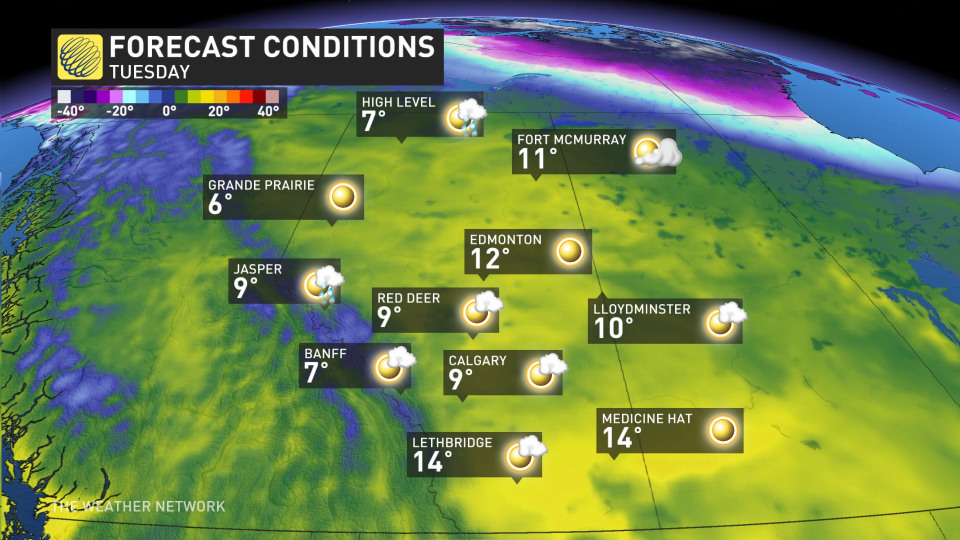
Tuesday looks to take the cake for high temperatures this week as downsloping winds race off the Rockies.
A ridge dominates the final days of January
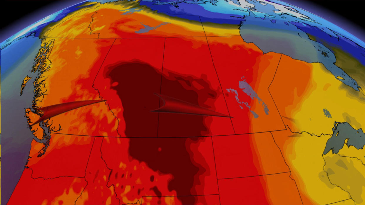
The abnormal warmth building over the Prairies will arrive courtesy of the same pattern responsible for drenching rains in British Columbia. We’ll see a formidable ridge building over the middle of the country this week.
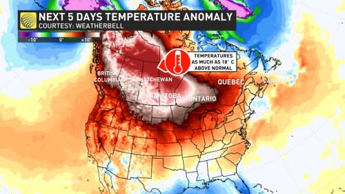
Mild air flowing in from the Pacific, combined with sinking air beneath the ridge itself, will work together to send temperatures far above seasonal from Winnipeg to Edmonton and even deep into the territories up north.
Readings will come in as much as 18 degrees above seasonal for many spots, especially on the northern Prairies and into the territories. Yellowknife’s high on Tuesday could come very close to breaking the all-time January record of 3.4°C measured on Jan. 3, 1985.
MUST SEE: All-time January heat records fall as astounding warmth hits North America

These winds will warm up and accelerate as they reach lower elevations, bringing the risk for gusts of nearly 100 km/h in the Alberta foothills, and widespread gusts around 50 km/h all the way into Saskatchewan.
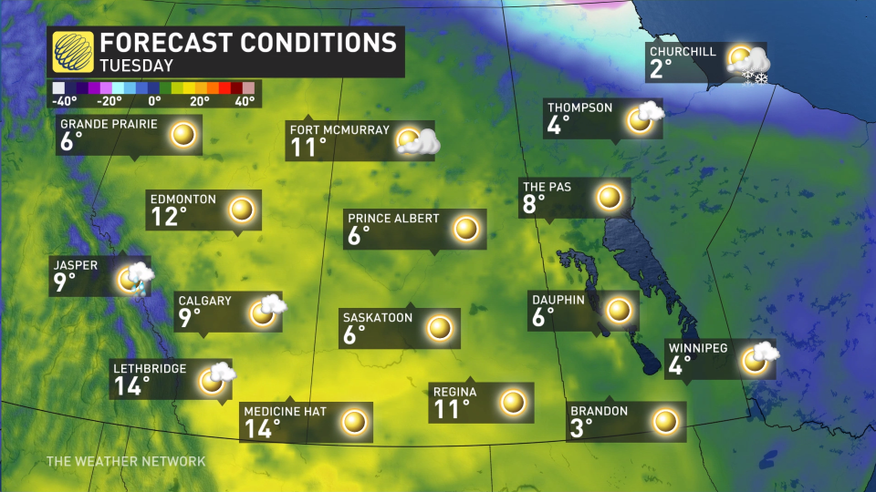
Warm winds will help Alberta’s temperatures climb a bit higher on Tuesday, with a comfortable 9°C in the forecast for Calgary and an impressive 12°C on the board for Edmonton.
Record-breaking temperatures are likely for some locations.
Folks in Edmonton will want to watch the decimal point on Tuesday as it is expected to reach 12°C, which would easily be the warmest January day on record for the international airport in Leduc. The previous record there was 9.9°C set on Jan. 25, 2006.
For the city, the record extends further back into 1881, but only two days in January have gone above 12°C.
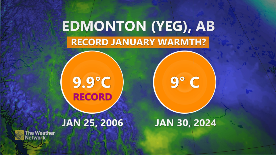
On Jan. 27, 1889, it reached 13.9°C, and on Jan. 29, 1931, it reached 12.8°C. If it hits its forecast of 12°C, it will be in the top three warmest January days on record, and the mildest in the past 90 years.
The warmest January temperature in provincial history will likely remain safe, a 18.3°C reading on Jan. 29, 1931 in Medicine Hat.
It’s not just an Alberta story. Temperatures on the eastern Prairies are also broiling, relative to normal, and the warmth also surges into the northern territories.
We may see the warmest temperatures pop up in southern Saskatchewan on Tuesday. Some models even boldly suggest temperatures could hit the upper teens in spots, which is about 25 degrees above seasonal.
Tuesday’s forecast high in Swift Current could easily secure its place as the warmest January temperature on record. The current record is more than a century old –– a 15°C reading back on Jan. 18, 1900.
A more active pattern is likely to develop across the Prairies for the opening days of February.
Stay with The Weather Network for the latest on your forecast across the Prairies.

