Jones Sausage to Glascock: The history behind some of Raleigh’s funny-sounding road names
The latest in our Asked & Answered series, in which we answer questions from the community, looks into street names in our region, specifically around Wake County and within Raleigh’s city limits.
Two readers asked the origin of the word “Level” in some of Wake County’s road names, wondering how roads like Apex’s Green Level West and Cary’s Green Level Church came about.
The News & Observer sat down with Ernest Dollar, executive director of the City of Raleigh Museum, to dive into our county’s history and learn more about some unusual street names we spot driving through Triangle towns.
“People are very curious about their sense of place, wondering about the namesake of their roads and towns and buildings,” Dollar said.
“There’s an influx of people from literally around the world who have a deep interest in trying to figure out just where they’ve landed and trying to understand the history of where they are.”
Does Raleigh have any unusual street names?
To many residents and visitors, many Raleigh street names might sound unusual.
Dollar says he’s often asked about the history of quite a few street names, with many longtime residents and first-time visitors thinking they’re funny — or because they are generally curious.
For those really interested in maps and North Carolina history, Dollar recommends spending some time with the North Carolina Maps website, put together by the state’s Department of Natural and Cultural Resources along with UNC’s University Library.
Search around and dive into state history at web.lib.unc.edu/nc-maps.
Some of Raleigh’s best street names
Dollar gets asked about a few specific Raleigh names the most frequently. Here’s a brief history of each of these places, helping us understand why we see these names on road signs today:
• Glascock Street: “This one always elicits a little bit of a chuckle,” Dollar said.
Dr. Harold Glascock designed Raleigh’s Mary Elizabeth Hospital. The building was relocated in 1978 and is now the Raleigh Community Hospital, which is a part of Duke Health.
• Six Forks Road: This road has nothing to do with tableware, and there aren’t any corresponding streets for spoons, knives or salad plates. Instead, it was named after a former community in northern Wake where six roads came together, The N&O previously reported.
• Lead Mine Road: People usually think this name came from mining the metal in this area of Raleigh, but it was actually a graphite factory for pencils.
“You can still go out to parts of the area and see veins of native graphite that they would mine for pencils,” Dollar said.
The mine dates back to the 1820s, The N&O previously reported. Surrounding street names include Mine Shaft Road, Prospector Place and Nugget Lane.
• Rock Quarry Road: A rock quarry used to be in this area, and the stones were used to build the State Capitol building, Dollar said.
• Jones Sausage Road: Named after the Jesse Jones Sausage Company, which was founded in Garner and has been owned by General Mills since the 1960s. Jesse Jones produces the “Southern Brand” hot dogs (which are apparently now made in Ohio) and the NC State Fair’s footlong hot dog.
How many ‘Level’ roads are in or near Wake County?
There are at least six “Level” roads in Wake County, said NC Department of Transportation spokesperson Aaron Moody.
Four Green Level Church Roads and two Green Level West Roads appear in the state-maintained system for Wake County, he said. The roads may connect, but the system shows them as different roads.
While there may be other “Level” roads maintained by municipalities within Wake County, they don’t appear in the state-maintained database, he said.
Some other “Level” roads in the area include:
Chalk Level Road in Durham
Frog Level Road in Greenville
Pine Level Selma Road, southeast of Raleigh between Pine Level and Selma
Bunnlevel Erwin Road in Bunnlevel, roughly an hour-long drive south of Raleigh
Locust Level Drive in Locust, a small rural city east of Charlotte
Why do so many Wake County street names have ‘Level’ in them?
It was common to name areas after a standout geographic feature, Dollar said.
In the 1920s, there was an effort to improve the state’s highway and road system. It’s likely these street names came from this era as the highway system expanded.
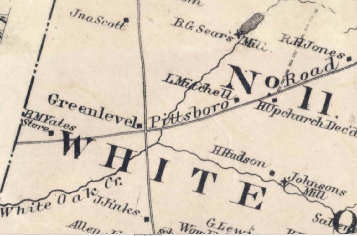
The Green Level community — located in rural western Wake and developed in the first half of the 19th century — was named “some say by an Indian, because the land in the area was exceptionally ‘green’ and ‘level,’” Dollar said.
“The Native American naming of Green Level is certainly part of the lore of the area.”
This community served as the commercial and social hub of a rural area that extended for many miles into the surrounding countryside. Travelers along the route — which ran from Raleigh to Pittsboro and intersected with Holly Springs — found the crossroads to be a convenient resting point.
“This stage stop is really important for us to understand its significance as ‘Level,’” Dollar said.
“These stage routes are the easiest to navigate, making sure they’re on high ground so the land doesn’t get swampy.”
Triangle Asked & Answered: What do you want to know?
Have a question about something in our community? The News & Observer’s Service Journalism team wants your questions for our Triangle Asked & Answered series. Reach out to us by filling out this form or by sending an email to ask@newsobserver.com.
Why are the lanes on Raleigh’s Wake Forest Road so scarily narrow? The answer.
Squirrels love chewing car wires. Here’s why — and how to get them to stop

