Kansans told to stay home amid storm expected to bring blowing snow and frigid wind chills
Topekans braced Tuesday for blizzard or near-blizzard conditions that forecasters predicted would bring blowing snow and the Capital City's coldest wind chill indices since 1989.
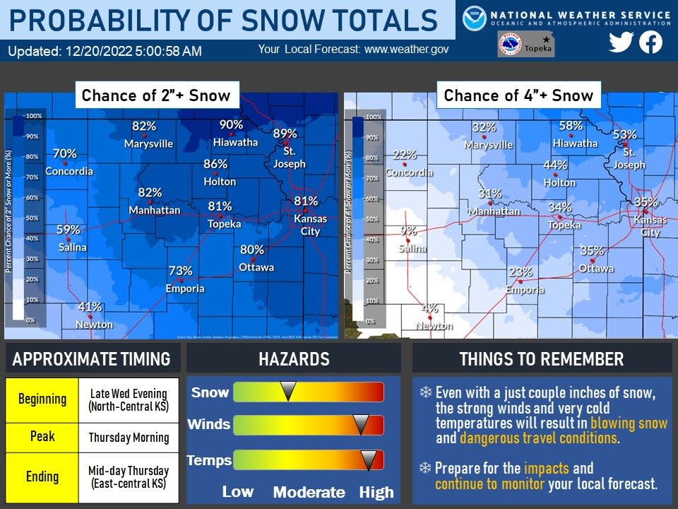
The storm, expected to move into the area late Wednesday, had an 81% chance of bringing Topeka at least two inches of snow and a 34% chance of bringing it at least four inches of snow, the National Weather Service's Topeka office said Tuesday on its website.
The weather service issued a winter storm watch, which will be in effect from midnight Wednesday to midnight Thursday, and a wind chill watch, which will be in effect from 6 a.m. Thursday to noon Friday.
"Very dangerous travel conditions are expected due to blowing snow creating low visibility, and extremely cold temperatures," said the Topeka office's website.
The weather service's forecast for Topeka calls for a slight chance of rain before 9 p.m. Wednesday, a slight chance of rain and snow between 9 p.m. and Midnight, then snow after Midnight.
Kits should include water, snacks and extra blankets
State officials encouraged Kansans to avoid traveling if they can.
Gov. Laura Kelly urged Kansans to prepare by making sure they have an emergency plan and a home emergency kit.
She suggested that kit include a battery-operated radio, a flashlight and extra batteries, extra blankets and warm clothing, nonperishable food, high-energy snacks and at least one gallon of drinking water per person per day, for a minimum of three days.
For more information on emergency kits, go online to https://www.ready.gov/kit.
The state in a news release urged drivers to keep an emergency supply kit in their car that includes jumper cables, flares or a reflective triangle, an ice scraper, a car cell phone charger, a blanket, a map and cat litter or sand to spread to provide better tire traction.
"If you do travel, make sure someone knows your travel plans and make sure your vehicle has a full tank of gas during extreme cold situations so that you can stay warm if you become stranded," the release said. "Ensure your mobile phone is charged, and make sure your car's emergency kit is up to date."
'The time where Topeka shines'
Officials from Topeka's city government, the Topeka Rescue Mission and Valeo Behavioral Health Care spoke at a news conference late Tuesday morning about how they were teaming up to help people who may lack the proper shelter or resources to deal with the potentially life-threatening weather the storm is expected to bring.
Valeo and TRM started outreach efforts in preparation for the storm on Friday, said city manager Stephen Wade, who is coordinating the effort. Shawnee County and the United Way are also involved.
Valeo chief executive officer Bill Persinger said partners in the effort were working to provide temporary places to stay, including motel rooms, for those who are unsheltered or "precariously housed."
"I think we will be able to be successful in helping everyone we can," said Topeka Mayor Mike Padilla.
TRM executive director Amanda Broyles described the partnership between government and nonprofit entities teaming up to help those in need as being "unprecedented."
Situations such as this week's are "the time where Topeka shines," with community members stepping up to help those in need, Wade said.
Trash pickup schedule revised, electrical utility prepares
An increased chance for power outages is expected due to the high winds anticipated to accompany the storm.
But the Evergy electrical utility monitors weather conditions and staffs its crews accordingly, so it is ready to respond to any outages as quickly and safely as possible, said Evergy spokeswoman Gina Penzig.
"To ensure reliability for our customers, we monitor electric circuits and may proactively reroute energy and balance demand on the system if necessary to prevent loss of power," she said.
Power outages can be reported online at evergy.com or by phone at 800-544-4857 (LIGHT-KS), Penzig said. Information about outages can be found on the online outage map that Evergy maintains.
Due to the potentially life-threatening outdoor conditions, Shawnee County's solid waste department won't pick up trash and recycling on Thursday and Friday, said Amanda Monhollon, the county's public information officer.
Collections will take place Wednesday for Thursday and Friday customers, she said.
The Topeka Zoo's "Zoo Lights" display will be open from 5 to 9 p.m. Tuesday and Wednesday, then closed Thursday, the zoo said in a news release Tuesday.
The display is then tentatively set to be open from 5 to 9 p.m. Friday and Saturday, it said.
The Shawnee County Courthouse and the Shawnee County government both announced they will be closed Thursday.
The Shawnee County Commission's 9 a.m. meeting Thursday will take place by Zoom, and can be viewed on the county's website and YouTube channel, said Amanda Monhollon, the county's public information officer.
Topeka's police and fire departments are available and ready to respond to any emergencies that might occur during the upcoming extreme weather, Topeka Police Chief Bryan Wheeles said at Tuesday's city news conference.
"We're here to serve, and emergencies are what we're built for," he said.
Hiawatha to see 58% chance of four inches of snow
The cold front moving Wednesday night through northeast Kansas will cause temperatures to plunge, north winds to increase and snow to move through the area behind the front, the weather service's Topeka office said.
Forecasters predicted a 73% to 90% chance of at least two inches of snow throughout northeast Kansas, including 81% at Topeka, 82% at Manhattan, 86% at Holton and 90% at Hiawatha.
A 31% to 58% chance of at least four inches of snow was predicted throughout northeast Kansas, including 34% at Topeka, 31% at Manhattan, 44% at Holton and 58% at Hiawatha.
Snow is expected to exit to the east by midday Thursday.
Northeast Kansas is expected Thursday afternoon to see winds from the northwest at 20 to 30 mph, and gusting to as high as 50 mph.
Wind chills could get as low as minus 30 to minus 40 early Friday morning, bottoming out at minus 33 at Topeka, forecasters said.
"While official records on wind chill are not kept, these wind chills may be the coldest across northeast Kansas since December 1989, when the wind chill reached minus 41 in Topeka," said the website for its Topeka office.
Friday will be the 33rd anniversary of the day Topeka saw its lowest temperature on record, when the mercury here dropped to minus 26 degrees on Dec. 23, 1989. The Capital City saw a low temperature of minus 22 on the previous day, Dec. 22, 1989.
Wind chill calculation formula has changed since 1989
The formula the weather service uses now to determine wind chill indices doesn't result in wind chills as low as those calculated under the formula that was in effect in 1989.
The weather service in November 2001 implemented an improved chart that uses advances in science, technology and computer modeling to provide a more accurate, understandable and useful formula for calculating wind chills.
While the prior formula found that a temperature of 5 degrees combined with 15 mph winds brought a wind chill index of minus 25, that figure is minus 13 under the current formula.
Contact Tim Hrenchir at 785-213-5934 or threnchir@gannett.com.
This article originally appeared on Topeka Capital-Journal: Topekans prepare to ride out winter storm featuring frigid wind chills

