Kayaks needed to navigate roads amid flash flood emergency


Less than one year after being hit by two major hurricanes, Lake Charles, Louisiana, was once again pummeled by an extreme weather event that left part of the city underwater.
Between Hurricane Laura, which made landfall on Aug. 27, and Hurricane Delta, which made landfall on Oct. 9, Lake Charles picked up 12.50 inches of rain, along with devastating winds, widespread power outages and storm surge along the coast.
The rainfall on Monday alone exceeded the rainfall accumulated during the two hurricanes combined in what has become the third-wettest day in the city's weather records, which go all the way back to 1895.
 |
Shortly after midday Monday, the National Weather Service (NWS) issued a rare flash flood emergency that is withheld for only extreme flooding events. "This is a PARTICULARLY DANGEROUS SITUATION. SEEK HIGHER GROUND NOW!" the emergency bulletin read.
Between 2 p.m. CDT and 3 p.m. CDT Monday, the weather station at the Lake Charles Municipal Airport reported 3.41 inches of rain. For comparison, the city typically measures 5.20 inches in all of May.
 |
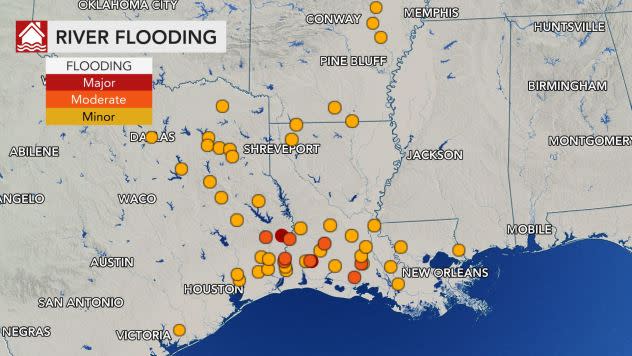
Several rivers in Texas and Louisiana were at moderate or major flood stage early Tuesday morning. |
The deluge of rain overwhelmed the city's drainage system causing roads, parking lots and front yards to transform into large ponds of water.
Not only were roads next to impossible navigate due to the flooding, but also due to vehicles that stalled out while attempting to drive on the underwater roads.
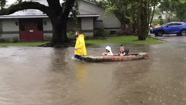
One man had to be creative to pick up his children who were stuck at school.
A road between his home and the school was completely flooded, so he towed a kayak through knee-deep water to pick them up and then pull them back home.
 |
A man uses a kayak to pull two children down a flooded street in Lake Charles, Louisiana, on May 17, 2021. (Twitter/ @jeremybabs) |
The weather pattern that lead to this record rainfall was much different than the devastating hurricanes that hit Louisiana in 2020.
A weather front stalled out over southwestern Louisiana on Sunday night and stayed overhead throughout Monday.
Moist air from the Gulf of Mexico "plowed into this stalled boundary and induced chronic thunderstorm development that remained nearly stationary over the same place for several hours," AccuWeather Meteorologist Brett Rossio said.
"This is what led to the incredible rainfall amounts across the greater Lake Charles area," he added.
CLICK HERE FOR THE FREE ACCUWEATHER APP
By the end of the week, widespread rainfall totals of 2-4 inches are expected from far-southern Texas and central Louisiana.
Waterways that could be at risk for major flooding are the Bayou Dorcheat, the Calcasieu River, the Sabine River and the Neches River that run across western Louisiana and eastern Texas.
Keep checking back on AccuWeather.com and stay tuned to the AccuWeather Network on DirecTV, Frontier, Spectrum, FuboTV, Philo, and Verizon Fios.
