Killer hurricanes without warning: Could one pop up quickly on the Mississippi coast?
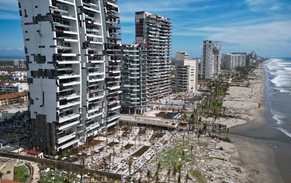
Residents and tourists were caught off guard as Tropical Storm Otis intensified to a Category 5 hurricane in about 12 hours. Dozens were killed in Acapulco, Mexico when the storm hit on October 25 and dozens more were reported missing.
Could Mississippi one day face a similar nightmare situation with the rapid intensification of a tropical storm?
It's a 'never say never' situation, but it appears unlikely.
Johna Rudzin, Mississippi State University Department of Geosciences assistant professor, said rapidly intensifying storms are relatively common in the Gulf of Mexico, but not to the degree of Hurricane Otis.
She used Hurricane Idalia, which made landfall in northern Florida in September, as an example.
"That was a Category 3," Rudzin said. "Idalia intensified pretty quickly.
"It happens quite frequently in the Gulf. It kind of happens enough that it's expected."
Rudzin said conditions in the Pacific Ocean differ from the Gulf and breed not only stronger storms in the Pacific. History has shown conditions can produce more rapid intensification. She pointed out that the second-fastest intensifying storm, Hurricane Patricia, which formed 2015, was also in the Pacific and in the same basic area as Otis.
"We haven't had rapid intensification like that," Rudzin said. "We've had rapid intensification in the Gulf of Mexico, but not to the scale of Patricia or Otis."
Could a hurricane catch the Gulf Coast states off guard?
Forecasters didn't predict the rapid strengthening of Otis, but Rudzin pointed out that again, there are differences. She said data-collection resources aren't as complete in the Pacific as they are in the Gulf. A key piece of that being hurricane hunter aircraft that are more readily available in the Gulf.
She said data collected by those along with satellite imagery and other data create models that might not be exact, but they are quite accurate.
"Most likely we wouldn't be caught off guard," Rudzin said. "Think of all the storms that have hit. Lots of the storms coming into the Gulf are really well-forecasted."
Climate change and hurricanes
In recent decades, whenever there is an unusual or unusually intense weather event, talk of climate change enters the conversation. It happened this past summer when temperatures all but made the Gulf boil and made many nervous because warmer water is fuel for intense hurricanes.
So, is climate change providing opportunity for more and more intense hurricanes? At least in the case of the Gulf, it's a complicated thing.
Rudzin said that while climate change makes certain conditions favorable for hurricane development, at the same time it makes other needed conditions less favorable. That could leave favorable conditions and unfavorable conditions cancelling each other out.
"It's very complex," Rudzin said. "It's a huge machine with a lot of little parts. There's a lot of little things that go on, so it's hard to pinpoint."
Could Mississippi see a rapidly-intensifying hurricane this year?
Hurricane season doesn't officially end until November 30. So, could Mississippi experience a hurricane or even a rapidly-intensifying hurricane this year?
According to the National Weather Service in Jackson, it's very unlikely.
"Actually, the front we just had come through is indicative of the pattern we experience through the month of November," said Daniel Lamb, NWS Jackson meteorologist. "So, that's to say once we have these cold fronts sweeping through, they basically deflect tropical storms from us as we get in the later months of the year."
Lamb said hurricanes have made landfall in Florida during November, but not here.
"It really gets difficult for these systems to get in the Gulf of Mexico this time of year," Lamb said. "If it happened this month, it would be unprecedented."
Cold, wet and yucky: See what else El Niño may bring to Mississippi this winter
Mississippi should be prepared
Hurricanes are problematic enough in Mississippi and a storm that strengthens rapidly before landfall adds another layer of danger that people should be aware of before it happens.
"It can change," said Malary White, chief communications officer for MEMA. "It can change very quickly.
"We're seeing more storms intensify rapidly. People should take these storms seriously."
White said residents in areas affected by hurricanes should be prepared to leave with at least three days of medications, food, water and other necessities. They should also know where they are going in advance.
People should also know where the safest place in their home is in the event they choose not to leave or can't leave for some reason. They should also know where storm shelters are located ahead of time.
White said when a storm is approaching, people should monitor weather reports closely and if it appears there's a need to evacuate, do so sooner than later and let someone outside the immediate family know where they are going.
"The last thing we want is lines and lines of cars trying to get out when it makes landfall," White said.
For more information on hurricane and other emergency preparedness, visit www.msema.org.
Violent weather: Chuck's Dairy Bar construction signals recovery in Rolling Fork, town decimated by tornado
Do you have a story idea? Contact Brian Broom at 601-961-7225 or bbroom@gannett.com.
"
This article originally appeared on Mississippi Clarion Ledger: Could Mississippi face a rapidly growing storm like Hurricane Otis?

