What kind of weather can Dallas-Fort Worth expect over the Christmas holiday weekend?
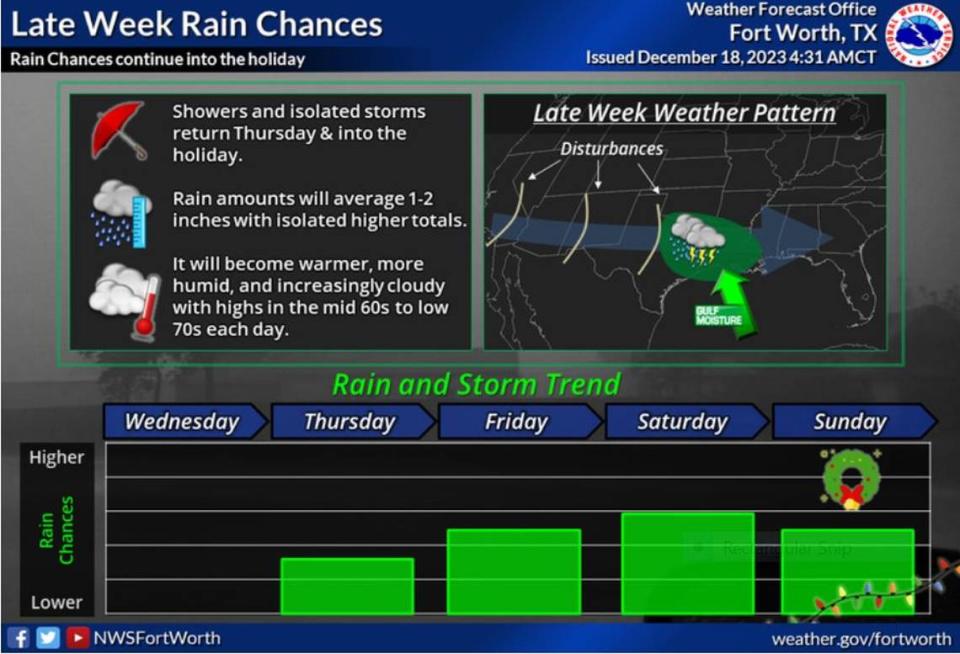
Rain is coming to the Dallas-Worth area by Thursday, increasing in intensity overnight and into Friday morning, bringing with it isolated thunder and storms, according to a National Weather Service report.
Once again, southerly winds will push moisture from the Gulf of Mexico into the region building up the clouds as light rain begins overnight Wednesday and continues into early Thursday, starting out west and making its way east.
“Rain chances return to the region Thursday morning, although meaningful rainfall amounts will hold off until Friday,” meteorologist Madison Gordon writes on the NWS website. “Temperatures each day will climb into the mid 60s to low 70s, around 5 to 15 degrees above seasonal normals.”
⚡ More trending stories:
→Will Dallas-Fort Worth get a white Christmas?
→Why are Krispy Kreme doughnut shops in Texas closing?
→ In Texas, how bright can LED lights be?
Another weather system out of the Baja Coast in Mexico will push its way to the Midwest, although the NWS says it still cannot pinpoint exactly what that might bring. But by the weekend, the new system will bring rain into North Texas — Christmas Eve for sure and lingering into Christmas Day, according to the NWS forecast.
The NWS expects 1 to 2 inches of rain likely in most parts of the region. There is a slight chance, a roughly 10% possibility, that some areas may see around 2 to 3.5 inches of rain.
The good news: “The threat for any flooding is low given these amounts will be dispersed over multiple days,” Gordon says.
What are the current weather conditions in Dallas-Fort Worth?
For now, North Texas can enjoy the frosty mornings with the day’s high temperatures hitting above 60 degrees.
“Seasonably cool conditions will take us through the start of the work week. On Tuesday morning, winds will shift back to the south with clouds streaming in from the west thanks to moisture aloft,” said NWS meteorologist Hunter Reeves.
Although another cool night is in store for North Texas Monday with lows in the mid 30s and into the mid 40s, the effect of radiation cooling will be dampened somewhat by increasing winds from the northwest. Some parts of the region may not experience freezing.
Is snow likely on Christmas Day in Dallas- Fort Worth?
With the lack of a “cold air mass forecast anywhere in the country” of late, the NWS is predicting with a high degree of confidence that the DFW area will not see snow this Christmas. Instead, rain is most likely to fall over the holiday weekend, the latest NWS report says.
The latest forecast is in line with what an El Nino weather pattern usually brings: wetter conditions.
Things can change depending on what happens in the Arctic region. If air becomes unstable and pushes the jet stream southward, the Polar Vortex effect could occur.
The polar vortex has extensive coverage of low pressure and cold air surrounding Earth’s poles. When the vortex is strong and stable, the polar jet stream shifts northward, keeping the cold air in the Arctic. But when the vortex weakens or is disrupted, the jet stream often becomes extremely wavy, allowing warm air to flood into the Arctic and polar air to sink down into the mid-latitudes.
The last time Texas experienced a “polar vortex effect” was last winter, when a cold front brought frigid temperatures and wind chills down to -15 degrees.

