What to know about upcoming prescribed burns
Kings Mountain National Military Park has announced a series of prescribed burns to be conducted within the park boundaries through the end of May.
Here's what you need to know:
Locations
North Central burn unit, 385 acres, combines Swale and Midway burn units. Swale unit is bordered to the west by Yorkville/Shelbyville Road, Midway burn unit to the east and to the south by the Clarks Creek, the Clarks Creek Trail, and the Battlefield burn unit. The Midway unit borders East line burn unit to the west in the park’s northeast boundary of the park. Unit is bound to the south by the Clarks Creek and the Clarks Creek Trail and to the west of Midway by the Swale burn unit.
Howser, 31 acres, located near the northwest boundary of the park, southwest of Rock House Road, and north of the Stonehouse Branch. Unit is contained by roads and natural boundaries. Northern boundary of this unit is Kings Creek. Rock House Road and the power line make up the eastern boundary. Stonehouse Branch makes up the southern boundary. Sections of Dellingham and Howser House roads form the western boundary.
Battlefield, 175 acres, located primarily behind the visitor center. The northern boundary of this unit is Colonial Road which branches south onto Yorkville Shelbyville Road. The trail system north from the visitor center serves as part of the Eastern Boundary. North Carolina Highway 216 (Main Park Drive) comprises the remainder of the eastern, southern, and western boundaries.
Mineshaft, 39 acres, northcentral portion of the park along Main Park Drive and the northern boundary. Unit is contained by an unnamed stream which has significant water flow sufficient to contain the fire. Unit is bound to the northeast by the Huffman Hill unit. The Park boundary (Duke Power right-of-way) serves as the northwest border of the unit. Private lands are adjacent to this right-of way, access has been granted to utilize the private property owners gate to access this portion of the unit with UTV’s and engine.
Preparation
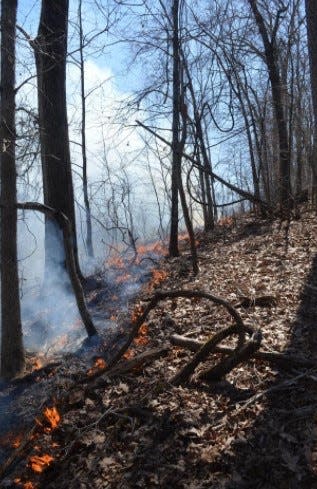
Wildland fire crews are working to prepare these units for safe and effective prescribed burns, conducted in accordance with the approved fire management plan and as weather conditions allow throughout the spring season. Surrounding communities may expect minimal smoke and visibility impacts during the burns. Some access to trails and grounds within the burn areas may be temporarily restricted during burn activities for visitor and wildland fire crew safety.
The timing of the prescribed burn implementation is dependent upon a variety of conditions as burns are conducted within specific parameters that consider temperature, relative humidity, fuel moisture, wind speed, and wind direction. The safety of firefighters and the public is the number one priority of all national park service wildland fire management activities. Informational updates and alerts regarding prescribed burn activities in the park will be posted on the park website and social media.
Justification
"Fire is an essential and natural process that has shaped the landscape of Kings Mountain National Military Park for thousands of years," read a press release from the park service.
Prescribed burns are conducted in the park to reduce the risk of wildland fire, and to restore native vegetation and historic landscapes. All areas of historic, cultural and ecological importance are identified and protected throughout the planning and implementation of prescribed burns.
Relevance
Kings Mountain National Military Park preserves the battle site of the first major patriot victory to occur after the British invasion of Charleston, South Carolina. Recreational trails, abundant natural resources, and interpretive programs that share the stories of those who fought in the conflict are told here. The nearly 4,000-acre park was established on March 3, 1931. For more information about Kings Mountain National Military Park, visit the park webpage at nps.gov/kimo and on Facebook at www.facebook.com/kingsmountainNPS.
This article originally appeared on The Shelby Star: What to know about prescribed burns at Kings Mountain Military Park
