Is La Niña making a return next winter? What does that mean for Boise’s weather in 2024?
The winter 2023/24 weather cycle has been dominated by one phenomenon: El Niño.
A stronger-than-normal El Niño brought record-warm temperature spells to Idaho and multiple atmospheric rivers to slam into the West Coast, bringing record rainfall to parts of the Pacific Northwest and heavy rain in Boise.
But now meteorologists are predicting the return of El Niño’s rambunctious sister, La Niña.
The National Oceanic and Atmospheric Administration predicts a 55% chance of La Niña developing between June and August and lasting into the winter.
“Even though forecasts made through the spring season tend to be less reliable, there is a historical tendency for La Niña to follow strong El Niño events,” NOAA stated in a February news release.
“The forecast team is in agreement with the latest model guidance, with some uncertainty around the timing of transitions to ENSO-neutral and, following that, La Niña,” NOAA continued. “Even as the current El Niño weakens, impacts on the United States could persist through April 2024.”
ENSO-neutral is the space of time when neither El Niño nor La Niña have developed. NOAA forecasts a 79% chance that El Niño will end between April and June.
With the forecast in place, what is a La Niña? And how will it affect Idaho?
What are El Niño and La Niña?
El Niños and their opposites, La Niñas, are naturally occurring weather phenomena that usually alternate every couple of years as a function of how the Pacific Ocean interacts with the air above it.
A La Niña occurs when the temperature of the sea is cooler than average in the eastern Pacific Ocean, resulting in less evaporation, weaker storms and less moisture in the atmosphere, according to NOAA.
We underwent a historic three-straight years of La Niñas, from 2020 to 2023, a rarity that’s only happened on two other occasions in recorded history, according to National Weather Service meteorologist Dave Groenert.
“The other two recorded times are 1973 to 1976 and 1998 to 2001. “It typically ping pongs back and forth, in general, from one to neutral to the other and back,” Groenert told the Idaho Statesman. “Sometimes you do get return years, but to get a third return year, I don’t know if anyone really knows as to why that’s the case.”
La Niña occurs when easterly trade winds — the permanent east-to-west winds that blow near the equator — strengthen, allowing the Pacific Ocean’s colder waters to upwell to the surface.
“La Niña events may last between one and three years, unlike El Niño, which usually lasts no more than a year,” National Geographic writes. “Both phenomena tend to peak during the Northern Hemisphere winter.”
What does a La Niña mean for Idaho?
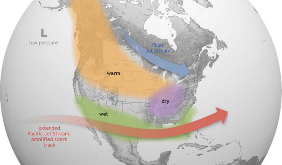
One of the defining characteristics of La Niña is a weakened jet stream over the eastern Pacific Ocean.
The colder sea surface temperatures off the western American coast force the jet stream northward toward Alaska before dipping southward into mainland North America once it’s over land.
This weather pattern typically leads to drier weather in the south, according to NOAA, but wetter weather for the Pacific Northwest. Temperatures are also normally colder throughout the country’s northern half during La Niña winters.
What would that mean for Boise?
A typical winter — from November to January — sees Idaho pick up 12.9 inches of snow and an average temperature of 34.9 degrees, so Boise residents can expect more snow and lower temperatures than those figures.

