Lake Shasta, McCloud Dam filling. Watch for fast, deep cold water this weekend
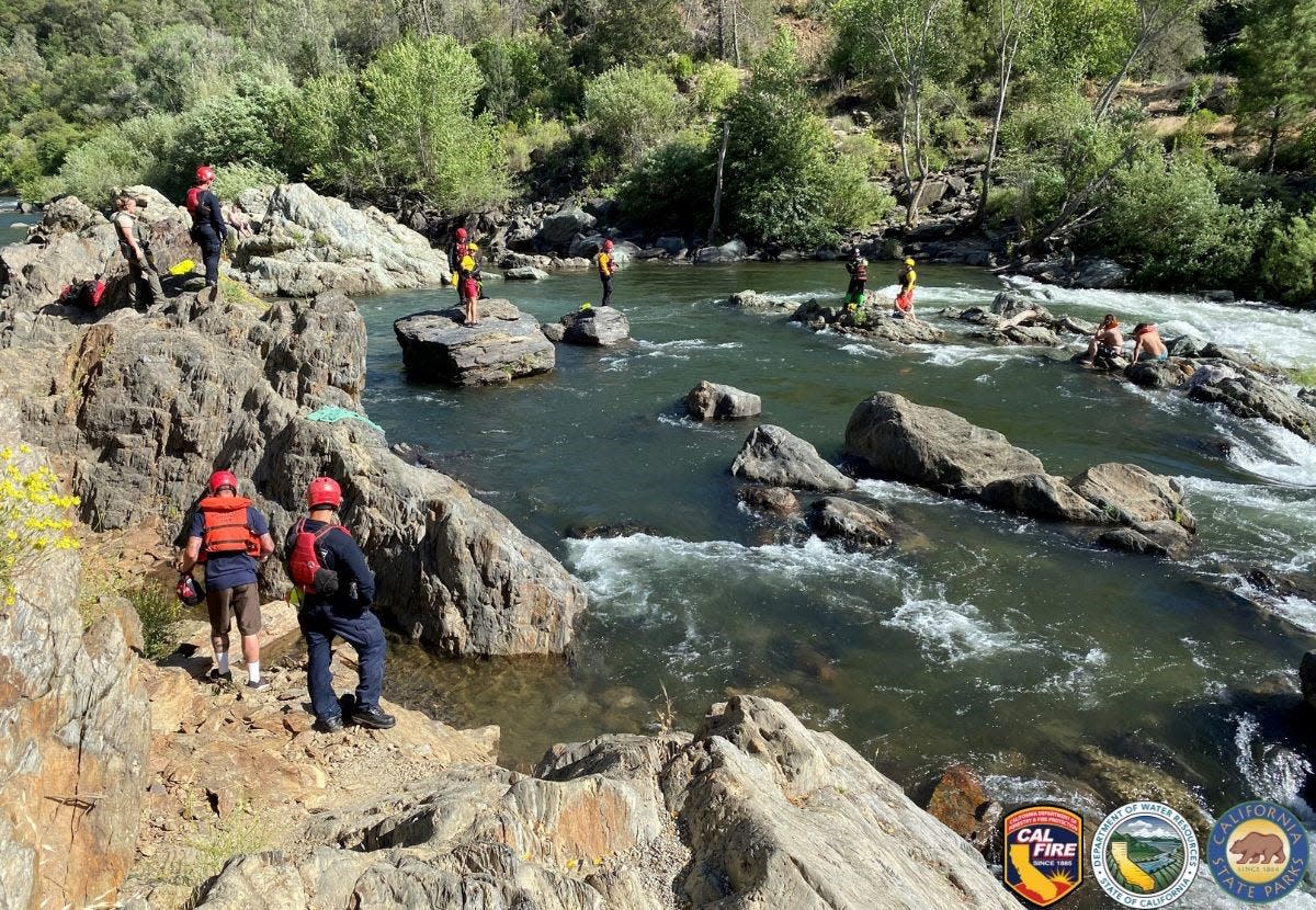
As the weather warms and people venture onto North State lakes and waterways, law enforcement and park officials in Shasta and Siskiyou counties are warning of fast-moving, frigid water that sweeps along logs, branches and other dangerous debris. They're asking swimmers, boaters and kayakers to check conditions before taking the plunge.
Noting "warmer temperatures finally hitting our area and a nearly full Shasta Lake," the Shasta County Sheriff’s Boating Safety Unit recently issued an announcement letting the public know that hazards also exist.
Those include sections of the lake where the water remains extremely cold, even if the air is warm. "Even experienced swimmers can lose muscle control quickly in cold water," officials said.
Another hazard for people taking the plunge is debris floating on waterways, sometimes carried by fast-moving water.
Just small pieces of debris can damage boat propellers or clog engine intakes, according to the agency. Hitting large chunks of debris ― such as logs or branches ― can seriously damage watercraft or even jolt passengers out of their boats, according to the agency.
Boaters and swimmers should wear lifejackets and keep their eyes open for debris that could be moving just below the water's surface, making it hard to see. Debris moves “throughout the lake depending on winds and water conditions, so it’s possible to encounter large debris anywhere on the water,” the sheriff’s office said.
Adults should keep an eye on children at all times, especially if they’re near, but not in, the water. Youngsters should always wear a lifejacket, according to the California Department of Forestry and Fire Protection.
How'd this happen?
Lake Shasta, the Shasta Dam Reservoir, was 98% full on May 7, according to the California Department of Water Resources.
As the weather continues to heat up, heavy snows that fell in the mountains and foothills during the winter will continue to melt, pouring into the Sacramento River and nearby waterways, according to Eric Kurth, a spokesman at the National Weather Service in Sacramento. How fast that happens will depend on how quickly it gets hot, he said.
Other possible water hazards include now-shallow sections in areas that were bone dry last year. Since it has been several years since the Lake Shasta was full, the sheriff's office said, some landmarks look different or could be completely submerged. Areas that once were well above the water line "are now navigable and have created new shallow areas or islands,” cautioned the agency.
Possible flooding as heavy snow melts?
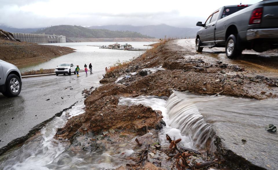
State and county agencies are bracing for possible summer floods as one of the heaviest statewide snow packs ever recorded liquifies.
“Just as the drought years demonstrated that California’s water system is facing new climate challenges, this year is showing how the state’s flood infrastructure will continue to face climate-driven challenges,” Department of Water Resources spokesperson Jason Ince said in April.
Despite warm weather in late April and some flooding in the south Sacramento Valley, “the statewide snowpack overall melted at a slower pace than average” because of cloudy skies and cool temperatures, according to a snow survey report issued by the water resources department on May 1. The equivalent of about a foot of water in the state’s snowpack melted in April and now contains an average of 49.2 inches of water, according to the report.
In parts of Siskiyou County, snow levels reached more than 200% of their historic averages at highest altitudes, according to the National Weather Service.
Then, winter storms pummeled parts of the North State, damaging national forest and park infrastructures, said Ruth Esperance, public affairs officer for the Shasta-Trinity National Forest. Future snow melt could cause additional damage to roads, bridges, trails, recreation sites and administrative facilities, she said.
Areas to watch for damage or flooding carrying fast-moving debris include Mud Creek near Mt. Shasta and parts of the west side of the forest, including North Fork Trinity, Bear Creek a quarter mile in on the Canyon Creek Trail, Stuart’s Fork and Landers Creek on Swift Creek Trail, Esperance said.
She recommended that people check for area closures at bit.ly/3Vvd2a2 before they visit the forest.
Parks at lower altitudes that were hit with heavy rains last winter also sustained damage.
In Whiskeytown National Recreation Area, "major storms back in January caused a landslide on Crystal Creek Road above Crystal Creek Falls," Supervisory Interpretive Park Ranger Scott Einberger said. The road at the Crystal Creek Falls Trailhead remains temporarily closed to vehicles, he said.
Pit, McCloud rivers run deep, water flowing fast and cold, PG&E warns
Other places people should watch out for fast moving water and debris include the Pit and McCloud rivers, according to Pacific Gas and Electric spokesperson Paul Moreno.
"Flows in the lower McCloud River from the McCloud Dam are about 400-450 cubic feet per second, but once the dam begins to spill" ― probably this weekend around May 14 ― "flows are expected to increase to about 900 to 1,000 cfs," Moreno said in a press release issued Friday, May 12. "Only one of two generators is operating at the J.B. Black Powerhouse, so less water than usual is being diverted from the McCloud Reservoir to Iron Canyon Reservoir and then to the powerhouse on the Pit River near Big Bend." McCloud Reservoir will probably fill soon and "excess water will come over the spillway into the lower McCloud River, which is that portion of the river between the McCloud Dam and Lake Shasta."
PG&E plans to gradually reduce flows into the McCloud River to around 200 cfs during the first week of June, he said.
The Pit River is another place to watch for water hazards, according to Moreno. “Flows on Pit River tributaries are also higher this year, including Fall River and Hat Creek," he said.
Water flows on the Pit River were “much higher than normal” in April, he said. “About 2,000 to 3,500 cubic feet per second in the Pit 3, 4 and 5 reaches, which are the portions of the river between each of the three dams and their respective hydroelectric power houses,” said Moreno.
Typical flows in those areas reach about 350 to 500 cubic feet per second, Moreno said. One cubic foot per second translates to a discharge of about 7.48 gallons of water per second.
PG&E crews expect to see similar flows in May, or even higher if a heatwave hits the North State for an extended period, melting the snow, Moreno said.
For cold water safety tips go to weather.gov/safety/coldwater. For boating safety tips go to shastacounty.gov/sheriff/page/boating-safety.
Jessica Skropanic is a features reporter for the Record Searchlight/USA Today Network. She covers science, arts, social issues and news stories. Follow her on Twitter @RS_JSkropanic and on Facebook. Join Jessica in the Get Out! Nor Cal recreation Facebook group. To support and sustain this work, please subscribe today. Thank you.
This article originally appeared on Redding Record Searchlight: Why Northern California boaters must watch for debris, cold fast water

