Lakeland to pay $280,000 to expand Catalyst 2.0 plans beyond downtown
LAKELAND — Lakeland officials unanimously voted Monday to spend $280,000 to ensure three communities are part of its 3D future.
Lakeland Community Redevelopment Agency will pay The Apiary, a Lakeland-based design firm specializing in photorealistic architectural visualization, to expand its future Catalyst 2.0 plans to include the areas of the East Main District, Downtown West, and Dixieland corridor.
The CRA will pay $200,000 from the Midtown CRA funds for the East Main District Master Plan and $40,000 each from Dixieland's South Florida Avenue Corridor Enhancement Fund and the Downtown CRA Catalyst Fund.
Previously: Lakeland prepares for Catalyst 2.0 to imagine its future growth possibilities
Katie Worthington Decker, in her new role as LEDC's senior vice president, gave Lakeland commissioners a preview of what progress has been made on Catalyst 2.0 since February.
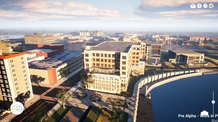
"This tool creates a digital twin of downtown Lakeland that we believe will inspire transformational Catalyst projects to improve our economy and quality of life of Lakelanders," she said.
The interactive tool has a surrealistic, video game-like quality that highlights the following features:
Developments that have happened in the past three years.
Buildings that are currently under construction.
Those projects in the permitting and design process.
And those proposed or visioned for the geographic area.
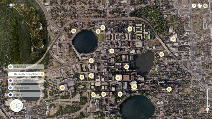
Decker shared an aerial view of the downtown area with a toggle that highlights one or more of the four categories, recent developments or buildings under construction for a user to click on. People will be able to get a real-time feel for projects, like the South Florida Avenue Road Diet.
"Imagine if when the city was discussing the Dixieland 'Road Diet' several years ago, instead of static photos such as this showing a before and after, we could have created a digital immersive rendering of the end product that would have allowed businesses and citizens of the corridor to bike, walk, drive around to get a feel for what the experience would be," she said.
Decker told commissioners she believes this kind of communication would have differently framed people's expectations of the test versus reality.
Other suggested examples of how the the Catalyst 2.0 map could be used would be to allow residents to see the difference between a three-story or four-story building, a controversial point on the Lake Miriam Square apartment proposal. Or allow residents to view an early rendering of the proposed Oak Street Apartments by Tampa-based developer Onicx Investments LLC, Decker said.
The Catalyst 2.0 map is being built on a web-based platform and made publicly accessible on the LEDC, Lakeland CRA and city's websites. It should be easily navigated with an interface similar to Google Map's streetview.
Oak Street: Lakeland approves Oak Street lot sale for 200 apartments, parking garage
Convenience store: Bodega Market coming to downtown Lakeland in space currently occupied by Silver Ring Cafe
The beta version will be live for Lakeland CRA next week, with a final public version launching this fall.
"No one has put one on their website that allows for citizen interaction," Matt Lukens, The Apiary's creative director, said. "There's one for Water Street in Tampa and there's one being worked on for Orlando. This one being a web-based application, I feel this will be pretty unique."
Lukens said the goal is to have architects who are working on development projects in Lakeland send files that can, with slight alterations to eliminate unnecessary data, be posted to create 3D rendering of upcoming projects. One example shown was a conceptual design for apartment buildings on property owned by Gregory Fancelli along Massachusetts Avenue.
For those developers not ready to reveal their plans and wanting secrecy, Decker said there will be a private mode.
While the core of downtown is being built, the first half of Phase 2 will be to add the East Main District. The Apiary will also provide visualizations for three new projects in either the Downtown or East Main Street and put them into the 3D platform. This work is slated to be completed by the end of September.
In the second half of Phase 2, The Apiary will work to build models of Dixieland and Downtown West hand in hand with the CRA's new master plans for these areas. The city's contract specifies The Apiary will work with local design firms to visualize three new projects for the CRA in any one of the four districts: Downtown, East Main, Dixieland or Downtown West.
Commissioner Stephanie Madden asked whether each development's traffic impacts will be modeled on the map after seeing a beta image.
"The No. 1 issue in our email box is traffic," Madden said.
Decker said traffic modeling is not included in the map features at this time, but it might be possible one day. She said it will be part of the ongoing discussion between Lakeland CRA, LEDC and The Apiary.
Sara-Megan Walsh can be reached at swalsh@theledger.com or 863-8020-7545. Follow on Twitter @SaraWalshFl.
Correction
An early version of this story incorrectly stated the Lakeland Economic Development Council would pay The Apiary for the interactive Catalyst 2.0 map. While the LEDC paid the initial phase, the $280,000 for Phase 2 will be paid by from the Lakeland CRA.
This article originally appeared on The Ledger: Lakeland's Catalyst 2.0 will include East Main, Dixieland, Downtown West

