Ingham County officials urge people not to travel as crashes spread
Updated 8:50 a.m. Saturday
The Lansing area had around four inches of snow this morning, according to several snowfall totals collected by the NAtional Weather Service.
Check around the state for local snow totals, and don't forget to check the timestamp because some of the totals are from Friday evening and some from Saturday morning.
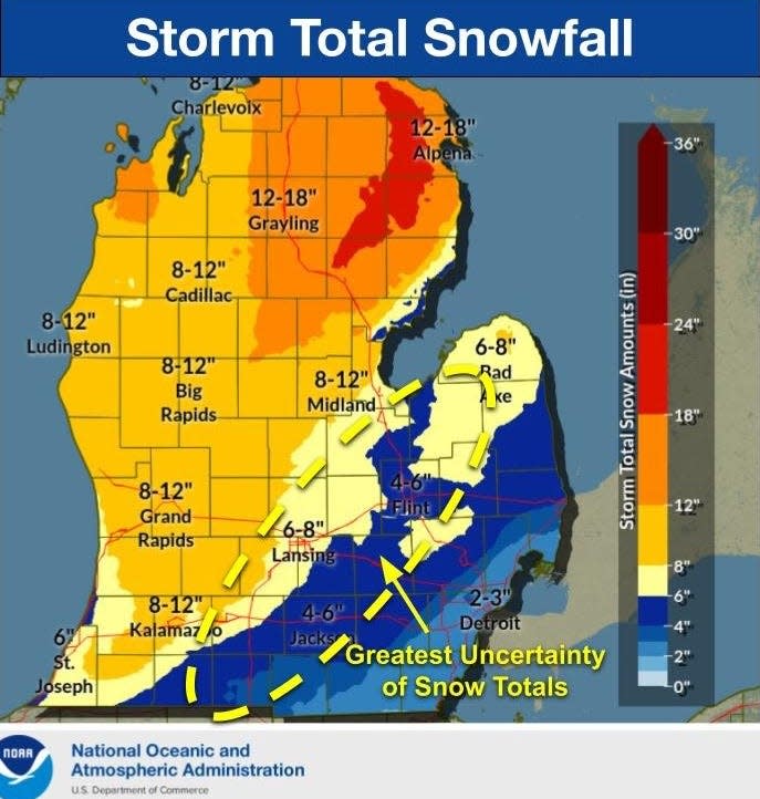
The highest Lower Peninsula totals reported, as of 9 a.m. Saturday, were in West Branch (15 inches) and Gladwin (12 inches).
The Grand Rapids area varied from around four inches to eight inches and the Detroit metro area generally saw less snow, ranging from around an inch to 8.5 inches in Ortonville.
Updated 6:45 p.m.
Ingham County emergency agencies on Friday evening urged people not to travel as conditions from a winter storm made roads hazardous.
Officials in an electronic alert said multiple crashes had been reported since the storm began late Friday afternoon.
"Multiple crashes are occurring on roads throughout Ingham County! Please avoid traveling unless absolutely necessary," officials wrote."If you see a car off the road that has caution tape on the side mirrors, wipers, or antenna, that means it has been checked by police and/or fire and does not need to be reported."Consider installing the What3Words app on your phone as it can help our 911 Center precisely determine your location if you slide off and aren't exactly sure where you are. See https://what3words.com/."
Storm arrives in Lansing area as travel conditions worsen
Updated 4:45 p.m. Friday
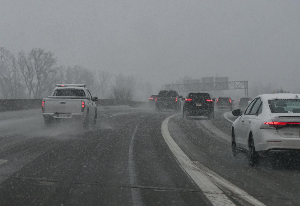
The much-anticipated storm arrived this afternoon, pretty much on schedule, with big snowflakes blowing horizontally as much as falling vertically in Lansing.
Officials were warning people to stay off the roads as conditions continued to worsen. At least three flights from Chicago and two from Detroit were canceled by evening hours at the Capital Region International Airport, and at least one flight from Orlando, Florida, was expected to be delayed.
"This snow will continue to spread north, so if you're in northern areas and snow hasn't started flying yet, expect to see it soon! Avoid traveling if possible!" the National Weather Service said in a social media posting.
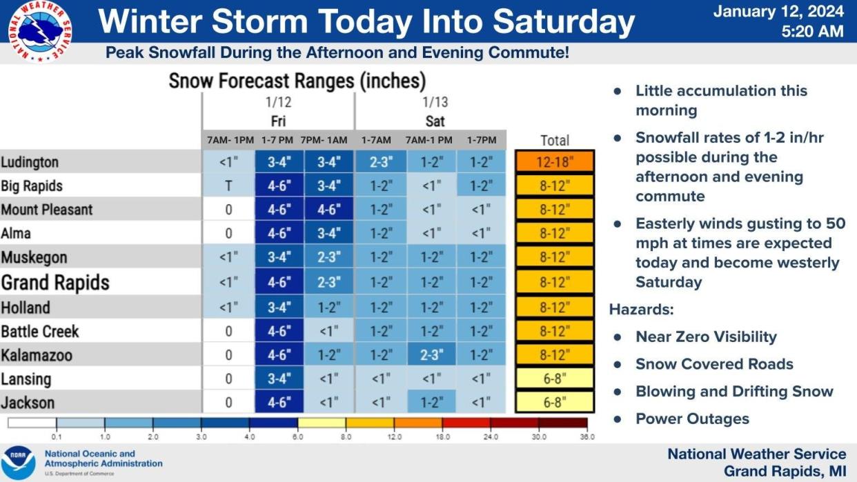
Snowfall totals are expected to range from 6-8 inches or so in Lansing to higher amounts as the storm moves further north, including 8-12 inches in some areas of Clinton County. Parts of the Upper Peninsula are forecast to get 18-24 inches of snow.
Code Blue issued
A "Code Blue" emergency plan was authorized for the city of Lansing so the Department of Human Relations & Community Services and the Lansing Fire Department’s Emergency Management Division can take steps to protect residents. It also gives shelters more leeway in accepting people and opens some buildings as temporary shelters.
The "Code Blue" will be in effect from 5 p.m. Friday to 5 p.m. Tuesday.
Lansing shelters open during the day Monday-Friday: Holy Cross New Hope Center, 430 N. Larch St.
Lansing shelters open during the night Monday-Friday: Holy Cross New Hope Center, Outreach Drop-In Center City Rescue Mission, 601 N. Larch St., and Nighttime Warming Center Letts Community Center, 1220 W. Kalamazoo St.
Lansing shelters open during the day Saturday-Sunday: Advent House, 743 Martin Luther King Jr. Blvd.
Lansing shelters open during the night Saturday-Sunday: The Outreach Drop-In Center City Rescue Mission and Nighttime Warming Center Letts Community Center
Libraries, community centers closing
All Capital Area District Libraries have announced closures for Friday. CADL will announce if the libraries will be open Saturday, but CADL has not said when updates would be available.
The East Lansing Public Library and East Lansing Hannah Community Center will close Friday at 5 p.m. and remain closed through Saturday.
Ingham County government closing early
Updated 12:35 p.m. Friday
Officials announced that Ingham County governmental offices will close at 3:00 p.m. Friday. Public safety and essential services will continue operating as usual.
Forecast stays on target for large storm
Updated 9:52 a.m. Friday
LANSING — While Greater Lansing braces for the brunt of an expected storm, here's the latest forecast from the National Weather Service in Grand Rapids.
Today: "A chance of snow before 3pm, then snow, possibly mixed with rain between 3pm and 4pm, then snow after 4pm. The snow could be heavy at times. Widespread blowing snow, mainly after 4pm. High near 34. Breezy, with an east wind 15 to 22 mph, with gusts as high as 41 mph. Chance of precipitation is 100%. Total daytime snow accumulation of around 3 inches."
Saturday: "Snow before 2pm, then snow showers, mainly after 2pm. Patchy blowing snow. Temperature falling to around 24 by 5pm. Breezy, with a west wind 22 to 24 mph, with gusts as high as 44 mph. Chance of precipitation is 90%. New snow accumulation of around an inch possible."
Sunday: "Snow likely, mainly before 1pm. Patchy blowing snow between 9am and 4pm. Cloudy, with a high near 17. Breezy, with a west wind 18 to 21 mph, with gusts as high as 30 mph. Chance of precipitation is 60%. New snow accumulation of less than one inch possible."
East Lansing bans street parking, to close offices early
Updated 7:30 a.m. Friday
EAST LANSING — City officials said offices are closing early Friday and street parking is being curtailed because of a winter storm moving into the area.
"To make the winter clean-up efforts as efficient as possible, community members should avoid parking on city streets on Friday and Saturday during the city’s efforts to clean up during and after the storm," officials said in a press release.
Overnight street parking will be suspended from 2 a.m. to 6 a.m. starting Friday through Sunday.
City offices and facilities will be closing early or working with reduced staff Friday, including the East Lansing 54B District Court, which will close at noon and operate remotely from 1 p.m. to 4 p.m. and the East Lansing Hannah Community Center, which currently plans to close at 5 p.m.
LCC moves to online classes, K-12 schools closed Friday
Updated 9:15 p.m. Thursday
Lansing Community College said Thursday evening it was suspending on-campus operations ahead of an expected Friday snowstorm.
The school said online classes would continue Friday.
LCC is suspending on-campus classes and operations on Friday, Jan. 12, for winter weather. Online classes to continue.
Dozens of public and private schools across the region announced Thursday night they would be closed. That includes Lansing, East Lansing, Okemos, Haslett, Holt, Mason, Leslie, Stockbridge, Williamston, Webberville and Dansville public schools in Ingham County, according to WILX TV-10 and notices on social media and district websites. Closings in Clinton County are also widespread, including St. Johns, DeWitt, Bath, Ovid-Elsie, Fowler, Pewamo-Westphalia and Ashley public schools. In Eaton County, Waverly, Grand Ledge, Charlotte, Bellevue, Olivet, Eaton Rapids, Potterville and Maple Valley public schools are closed Friday. Fulton was scheduled for a half day of classes. Additionally, Portland and Owosso public schools are closed, as are Clinton County RESA, Eaton County RESA and the Ingham County ISD.
Lansing forecast: Heavy snow, strong winds, extreme cold beginning Friday
Updated 2:30 p.m. Thursday
LANSING — Forecasters believe the big storm expected this weekend across lower Michigan will be a "multi-faceted" affair with good measures of heavy snow, rain, gusty winds and extreme cold.
A winter storm warning will be in effect from 10 a.m. Friday until 7 p.m. Saturday.
As far as they could surmise on Thursday afternoon, the storm system will make itself felt with heavy snow beginning Friday afternoon, followed by rain or drizzle, before switching back to snow, said Brian Meade, a meteorologist with the National Weather Service in Grand Rapids.
Cold air will rush in behind the front overnight Friday, turning the snow into the typical, drier January variety, he said.
"It's kind of a multi-faceted system with various things going on during the course of the event," Meade said.
The heaviest snow was expected to come between 4 p.m. and 10 p.m. Friday, with the white stuff falling at a rate of an inch or two an hour and winds gusting to around 40 mph, Meade said.
Snowfall totals were uncertain, but Lansing was expected to get around 6 to 10 inches, with generally higher numbers west and north of Lansing and decreasing numbers to the south and east, he said. That's because Lansing will be on the edge of the ridge of warmer air that could bring rain on Friday evening, he said.
"The (Friday) evening commute is going to feature some very heavy snow," Meade said. "People are going to want to wrap up their travel before that (typical) commute time."
The forecast called for highs in the high 20s on Saturday and in the high teens on Sunday. Temperatures on Monday and Tuesday probably won't exceed 10 or 15 degrees, Meade said.
Lake-effect snow could add a few inches to Lansing's storm total heading into next week, he said.
Updated 11:45 a.m. Thursday
Friday school closings possible
LANSING — Local school districts are considering canceling classes for Friday, but a final determination won't happen until later tonight.
Ingham County superintendents are planning on meeting at 8:00 p.m. Thursday to discuss cancellations. However, just because they discuss closing schools together, does not mean that all of the schools in the county will.
Each district has different needs. Some, like East Lansing Public Schools and Lansing School District, do not need to be as concerned about how clear rural or side roads are, because most of their students live on paved roads.
The storm might worsen as the day goes on, which is something superintendents need to consider, said Dori Leyko, superintendent of the East Lansing school district. Early releases can be challenging, because elementary students can't as easily take the bus home or be by themselves if an adult is not at home with them.
School closures should be announced by 10 p.m. Thursday, or by 6:00 a.m. Friday morning. Cancellation of evening activities should be announced by 1:00 p.m. Friday.
Schools typically send out emails, robocalls, and robotexts, and they encourage families to check the local news for updates.
Lansing weather: More snow, blustery winds on the way
Updated at 10:28 a.m. Thursday
LANSING — Think twice about traveling.
Because of snow and wind, there are slick roads to navigate and travel plans to reconsider.
If you're expecting to fly or ride a train, make sure to confirm there are no delays or cancellations before leaving your home.
But so far, there are no canceled flights at the Capital Region International Airport, where maintenance crews are working to keep runways and taxiways clear.
Airport spokesperson Katherine Japinga said cancellations are up to airlines.
“Airlines make the decisions on flight changes/delays/cancelations, not the airport,” she said, in an email. “Anyone traveling the next few days should check directly with their airline for the most up to date and accurate information regarding flights.”
The Amtrak train service out of East Lansing is showing an available route for Friday morning's train to Chicago but the route for Saturday has been cancelled. Check Service Alerts & Notices | Amtrak for live updates.
Snow storm
The Lansing area could see as much as a foot of snow Friday through Saturday and that forecast is already impacting many events and plans for area organizations.
"Heavy snow and strong winds are expected for portions of Michigan Friday into Saturday," the National Weather Service said in an online post. "Main concerns are wind gusts of 30-45 mph and heavy snow causing blowing and drifting snow, whiteout conditions, power outages, and hazardous travel conditions."
The NWS said Lansing has a 76% chance to see at least 6 inches of snow from 7 a.m. Friday to 1 p.m. Saturday. There is a 19% chance the area could see a foot of snow if the expected storm's track shifts southeast.
The forecasted storm has led to a shift in some of the Greater Lansing varsity basketball games originally slated to take place Friday. Among the games shifting are CAAC Red boys basketball matchups featuring Mason at Eastern and Haslett against St. Johns and Fowlerville at Williamston. All three contests are taking place 7 p.m. Thursday.
NWS Forecast
This is the NWS weather forecast through Saturday:
Thursday: "A 30 percent chance of snow showers, mainly before 10am. Cloudy, with a high near 36. South southeast wind 8 to 13 mph becoming west in the afternoon."
Friday: "Snow, mainly after 10am. The snow could be heavy at times. Areas of blowing snow after 1pm. High near 34. Breezy, with an east wind 13 to 22 mph, with gusts as high as 38 mph. Chance of precipitation is 100%. New snow accumulation of around 3 inches."
Saturday: "Snow. Patchy blowing snow. High near 27. Breezy, with a west wind 24 to 26 mph, with gusts as high as 41 mph. Chance of precipitation is 90%. New snow accumulation of around 2 inches."
This article originally appeared on Lansing State Journal: Ingham County officials urge people not to travel as crashes spread

