Jason Aldean concert postponed as severe thunderstorms move through area
- Oops!Something went wrong.Please try again later.
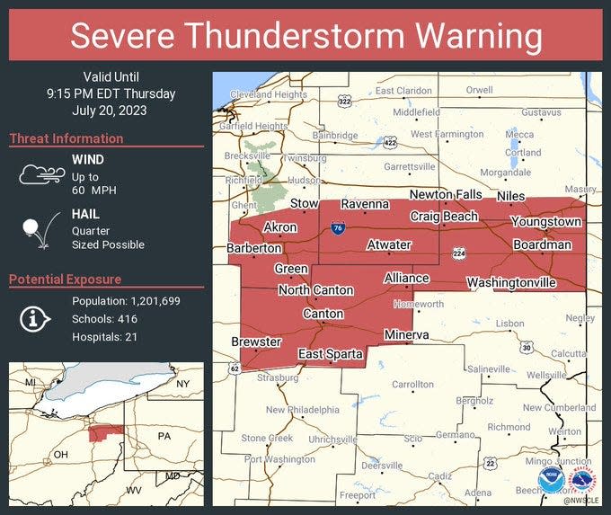
Fans attending the Jason Aldean show at Blossom Music Center Thursday were being asked to seek shelter as the National Weather Service extended a severe thunderstorm warning for northeast Ohio through 9:15 p.m.
Around 9 p.m., the Cuyahoga Falls concert venue announced the concert was being postponed.
"Due to severe thunderstorms in the area, tonight's Jason Aldean Highway Desperado Tour stop at Blossom Music Center has been postponed to Sunday, September 17th. All tickets will be honored for the new date. Please stay tuned to all social media channels for further details," Blossom posted on Twitter.
Due to severe thunderstorms in the area, tonight's Jason Aldean Highway Desperado Tour stop at Blossom Music Center has been postponed to Sunday, September 17th.
All tickets will be honored for the new date.
Please stay tuned to all social media channels for further details. pic.twitter.com/aZPcOUw3y3— Blossom Music Center (@BlossomMusicCtr) July 21, 2023
The show had been scheduled to begin at 7:30 p.m., which was about the time the National Weather Service issued a severe thunderstorm warning for the area.
"Attention Jason Aldean fans! We are currently monitoring weather and holding doors," the concert venue announced. "We ask that fans safely seek shelter at this time. If you are in the venue, please seek shelter in the nearest structure or building. If you have not entered, please proceed back to your car."
Conditions worsened until the weather service issued a tornado warning around 8:15 p.m. for areas including Wadsworth, Rittman and Doylestown until 8:45 p.m.
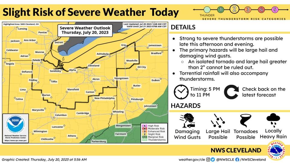
Forecasters said that storms are likely due to a strong cold front moving southeast across the region later this evening and tonight.
If a severe storm hits, among the risks are large hail − as big as a golf ball − along with torrential rainfall.
As of 3:30 p.m. the front was approaching Detroit and forecasters said it could reach the I-77 corridor between 5 and 6 p.m. and the Pennsylvania border by midnight, give or take an hour.
Storms were expected to move between 35-40 mph or more when they reach Ohio, with wind gusts of up to 70 mph possible along with a chance of isolated tornados.
Once the cold front pushes through, relatively chillier temperatures are expected with highs in the 70s on Friday.
A dry weekend is expected with highs in the lower 80s.
What's the forecast?
Friday: Partly sunny, with a high near 77. Northwest wind 7 to 10 mph.
Friday night: Mostly clear, with a low around 59. Northwest wind 3 to 7 mph.
Saturday: Sunny, with a high near 81. Northwest wind 5 to 8 mph.
Saturday night: Mostly clear, with a low around 59.
Sunday: Sunny, with a high near 84.
Sunday night: Partly cloudy, with a low around 62.
Monday: A chance of showers and thunderstorms after 2 p.m. Mostly sunny, with a high near 86. Chance of precipitation is 30%.
Monday night: A chance of showers and thunderstorms before 8 p.m., then a chance of showers between 8pm and 2am. Partly cloudy, with a low around 63. Chance of precipitation is 30%.
Tuesday: Sunny, with a high near 87.
Tuesday night: Partly cloudy, with a low around 65.
Wednesday: Mostly sunny, with a high near 88.
This article originally appeared on Akron Beacon Journal: Akron weather: Severe thunderstorms pass; Aldean concert postponed

