Large hail, damaging winds may accompany thunderstorms tonight in Canton area
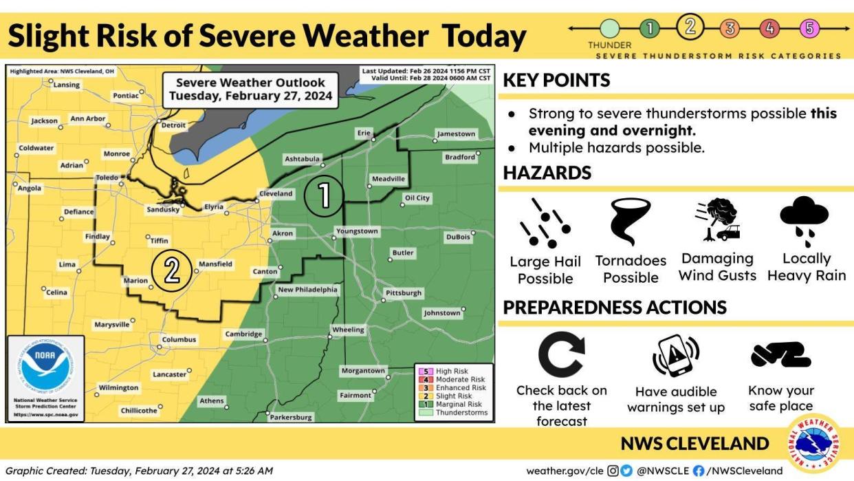
CANTON ‒ The National Weather Service says a round of strong to severe thunderstorms is expected to develop and move east across the area from tonight into Wednesday morning. The primary hazard will be large hail and damaging wind gusts.
The outlook covers North Central Ohio, Northeast Ohio and northwest Pennsylvania.
Large hail is the primary threat overnight for Northwest and North Central Ohio, which face the added chance of a tornado or damaging winds tonight into early Wednesday.
On Sunday and Monday, the Canton area is expected to see sunny skies and highs of 68 degrees.
Today's forecast for the Canton area says showers and thunderstorms are likely, mainly before 1 p.m. It will be mostly cloudy, with a high near 66. The wind will blow south at 10 to 14 mph with gusts as high as 26 mph. The chance of precipitation is 60%. New rainfall amounts of less than a tenth of an inch are expected, with higher amounts possible in thunderstorms.
Tonight, expect showers and thunderstorms, mainly before 5 a.m., then showers and possibly a thunderstorm after 5 a.m. The low temperature will be around 57. There will be a south wind of 11 to 16 mph, with gusts as high as 31 mph. Chance of precipitation is 90%. New rainfall amounts between a quarter and a half of an inch are possible.
What's the forecast for Canton weather?
Here's what to expect next:
Wednesday: Rain showers before 4 p.m., then a chance of snow showers. Some thunder is also possible. Temperatures rising to near 63 by 8 a.m., then falling to around 36 during the remainder of the day. Breezy, with a south wind 16 to 23 mph becoming west in the afternoon. Winds could gust as high as 39 mph. Chance of precipitation is 80%. Little or no snow accumulation expected.
Wednesday night: A chance of snow showers before 1 a.m. Mostly cloudy, then gradually becoming mostly clear, with a low around 23. Breezy, with a west wind 17 to 22 mph, with gusts as high as 34 mph. Chance of precipitation is 30%. New snow accumulation of less than a half inch possible.
Thursday: Sunny, with a high near 38. West wind 11 to 14 mph. At night, it will be mostly clear, with a low around 26.
Friday: Partly sunny, with a high near 50. At night, a chance of showers. Mostly cloudy, with a low around 40. Chance of precipitation is 30%.
Saturday: Partly sunny, with a high near 57. At night, partly cloudy, with a low around 42.
Sunday: Mostly sunny, with a high near 68. At night, partly cloudy, with a low around 49.
Monday: Mostly sunny, with a high near 68.
This article originally appeared on The Repository: Canton weather forecast calls for strong to severe thunderstorms

