11 People Dead as Storm System Brings Severe Weather and Record Temperatures Across the U.S.
At least 11 people were killed by severe storms that brought high winds, tornados and rain from the southern United States to the Midwest this weekend, according to the Associated Press.
Fortunately, the strong winter storm is expected to “wind down” on Sunday as the risk of severe thunderstorms, heavy rain and flash flooding goes down, the National Weather Service forecasts. However, the Upper Mississippi Valley and the Upper Great Lakes are expected to receive two to four inches of snow on Sunday.
In the Northeast and mid-Atlantic, record-high temperatures are expected to be broken as temperatures rise 15 to 25 degrees above normal, the National Weather Service says.
Heavy snow in Northwest, northern New England
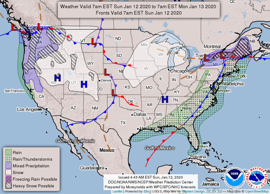
In the eastern United States, the risk of severe thunderstorms, flash floods and heavy rains is expected to calm down on Sunday. However, other regions can expect to experience severe weather, according to the National Weather Service.
In northern Maine, forecasted ice accumulations of a quarter to one half inches could damage trees, cause power outages and make traveling dangerous on Sunday. Parts of northern New England could also experience heavy snow.
A storm system in the Pacific Northwest could bring moderate to heavy snow in the Northern and Central Rockies, as well as the Intermountain West, until Tuesday. One to two feet of snow are forecast in the Central Rockies, Eastern Oregon and Northern Idaho. Then on Monday, there could be heavy snow in California’s Northern Sierra Nevada Mountains.
Snow is starting to accumulate across NE Nebraska and NW Iowa and will continue to spread into the morning hours.
Before you head out, be sure to check https://t.co/5QyQP7m7Dp or dial 511 for the latest road conditions. pic.twitter.com/LASocT74qA— NWS Sioux Falls (@NWSSiouxFalls) January 12, 2020
On Sunday, the Upper Mississippi and Upper Great Lakes could also receive two to four inches of snow.
Record High Temperatures
Long-standing record temperatures across the mid-Atlantic and East fell as temperatures rose into the 60s and 70s.
In areas across the region, the highs shattered records held for decades — and in several cases, longer than a century. In Pittsburgh, Penn., the temperature rose to 70 degrees, breaking the 68 degree record set in 1890. In Morgantown, W.V., the temperature rose to 74 degrees, beating the 70 degree record that stood since 1880.
Update on Saturday's high temperatures...a number of sites saw temperatures continue to rise during the evening, with another 7 locations reaching or exceeding their record high for January 11th. Another half dozen bumped their record higher before midnight. pic.twitter.com/cEK6xRdnxp
— NWS Eastern Region (@NWSEastern) January 12, 2020
Multiple temperature records were also broken in the New York City area, according to the National Weather Service. Temperatures rose to 67, 66 and 69 degees Fahrenheit in Central Park, LaGuardia and Newark, NJ, respectively, breaking the records set in 1975.
Record high temperatures have been set for today's date at Central Park, LaGuardia, and Newark, NJ. The temperatures reached as of 12:40 pm for these respective locations are 67, 66, and 69. This breaks the records that were previously set back in 1975!
— NWS New York NY (@NWSNewYorkNY) January 11, 2020
To the south, the unusually warm weather was accompanied by weather more typical of the spring — severe thunderstorms. On Saturday night, there were several tornadoes and wind damage in the Southeast, Ohio Valley, southern Appalachia and the southern mid-Atlantic.
With spring-like temperatures, unfortunately sometimes come spring-like severe thunderstorms. Widespread wind damage and a few tornadoes reported Saturday-Saturday night across the Southeast, Ohio Valley, southern Appalachians and southern mid-Atlantic regions. pic.twitter.com/Ubc6czmTHO
— NWS Eastern Region (@NWSEastern) January 12, 2020
The survey team from Pickens County has sent back a preliminary report that the damage they are seeing is rated at least EF2, at 134 mph. The survey is still ongoing, and more details will be shared when it is available. #alwx pic.twitter.com/rPecIRWPne
— NWS Birmingham (@NWSBirmingham) January 12, 2020
On Sunday, temperatures were expected to remain unseasonably warm, and more record temperatures will likely fall, according to the National Weather Service.
Here is a look at the high temperature forecast for Saturday and Sunday. Some locations could see record high temperatures for the dates. pic.twitter.com/uQdFp0HeLV
— NWS Eastern Region (@NWSEastern) January 9, 2020

