A last-ditch push for St. Joseph County commissioners to rethink election maps
SOUTH BEND — With St. Joseph County commissioners poised to approve new election maps that could tilt the local balance of power toward Republicans for the next decade, critics made a last-ditch plea Monday night for a delay in the controversial redistricting plan.
The commissioners approved the maps in a preliminary 2-1 vote last week, and there’s been no sign of change ahead of Tuesday, when the county’s executive body will take a final vote on the plan.
Democratic members of the County Council and Commissioner Derek Dieter, a Republican, held a public forum Monday night to solicit feedback. They and other opponents of the proposed maps say they still want to work to come up with more competitive districts.
“I offered my help to the commissioners to draw a map that is better than both their proposed maps and mine, and hopefully better than the current ones, too,” Ranjan Rohatgi, a professor of mathematics and computer science at Saint Mary’s College, said Monday during a public forum at the Charles Martin Youth Center in South Bend.
“I want all of us to work together in a public way to do that, and that’s not what happened.”
More: St. Joseph County Commissioners vote 2-1 for controversial election maps
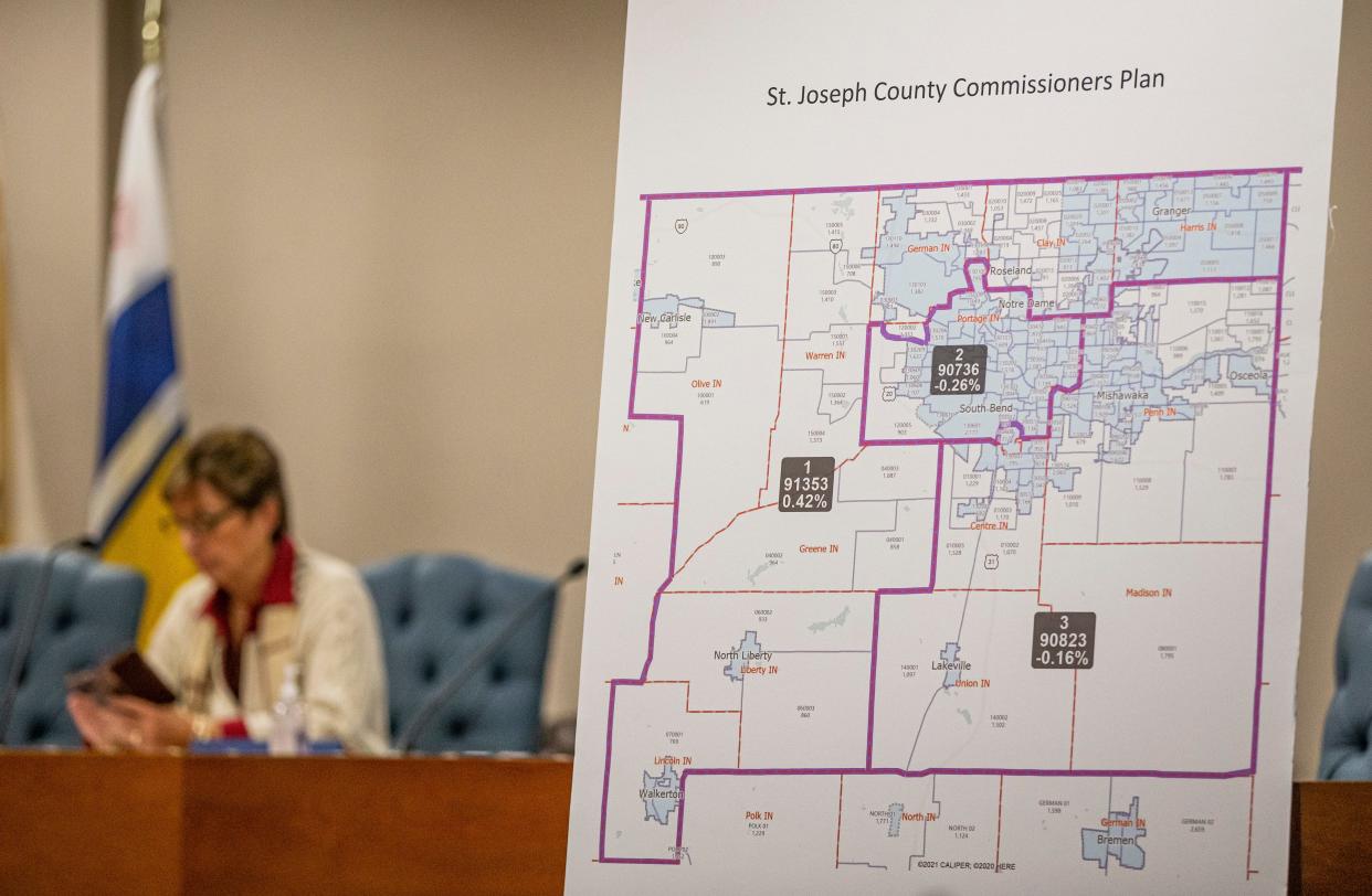
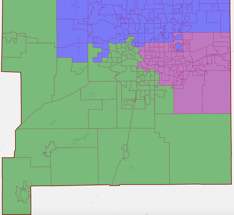
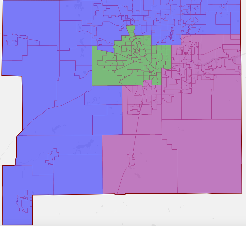
Under the maps, two of the three commissioner districts would become more Republican, while racial minorities would be shifted into a third district that would be shrunk to the South Bend city limits and become overwhelmingly Democratic.
By sacrificing District 2, currently represented by Dieter, the GOP would gain bigger edges in districts 1 and 3, represented respectively by Commissioner Andy Kostielney and Commissioner Deb Fleming.
Districts for the County Council, the legislative branch, must be drawn within the commissioner maps. At stake for Democrats is a 6-3 majority on the council, which allows them to override vetoes by the Republican-controlled commissioners.
Council Democrats said Monday they have tried to reach the commissioners multiple times to work together on the maps but have gotten no response from Kostielney or Fleming.
Kostielney formed his proposed maps with help from former Indiana House Speaker Brian Bosma’s law firm. He and Fleming voted for the plan last week, while Dieter opposed it.
Kostielney has denied the maps are intended to create political advantages for Republicans, though he has refused to say whether Bosma’s firm was given any political goals or to release records generated by the firm in creating the plan.
Kostielney has said the goals of the plan are to give the three commissioner districts equal populations, to avoid splitting “communities of interest” such as the city of South Bend and the county’s township between multiple districts, and to eliminate oddities such as “island” precincts that belong to one district but are wholly surrounded by another.
Voices in favor and against
Thirteen people spoke in favor of Kostielney’s proposed maps during Monday’s forum. Several said the proposal would improve the county’s current maps, which they said looked as if they had been gerrymandered because of their irregular lines.
“If you look at the old maps, they are obviously gerrymandered,” said Amy Drake, of Granger. “I can look at it right now, and I can see islands on those maps. These new maps are a major improvement.”
When the county’s existing district maps were drawn in 2011, Fleming, who was the county GOP chairwoman at the time, praised the Democrat-controlled commissioners for “doing what is best for the voters of St. Joseph County and not just the Democratic Party.”
Kostielney, who was the lone Republican commissioner in 2011, said the maps were “fair” and “made a lot of sense.”
More: Unlike today's controversy, current St. Joseph County redistricting had bipartisan praise
At Monday’s forum, Drake rejected the notion that the maps should create competitive elections, rather than two strong districts for Republicans and one for Democrats. Drawing the maps to be competitive, she said, would amount to “socially engineering communities to lead to an unnatural result.”
Supporters of the new maps have also said South Bend residents would benefit from having one commissioner represent the entirety of the city, while suburban and rural voters would have commissioners focused on their interests.
“I don’t know if I’ve ever seen a map that looks as nice as this one,” said Maureen Goetz, of South Bend. “If you asked my first-grader, who does love maps, he would say that one looks like it makes more sense.”
But critics have pointed out that under Kostielney’s proposal, the commissioner representing most of the county’s minorities would likely always be outnumbered 2-1.
“How many Black people live in Granger? How many Black people live in Mishawaka,” said Nancy Simon, of South Bend. “Basically what you’re saying is, we’re keeping white people together in St. Joe County, and we’re keeping all these Black folks together.”
Simon was one of 11 people who spoke against the proposal.
When Dieter asked those who attended Monday’s forum in person to show who supported the proposed maps, about a dozen people stood. When he asked to see how many opposed the plan, about three dozen people stood.
Critics have said the plan could raise legal concerns by “packing” many minority voters into one district, leaving them with little influence in the other two.
Democratic county Auditor Mike Hamann, who previously served as a Republican commissioner, said Monday that Kostielney’s plan would create a Democratic “ghetto” and was clearly motivated by politics.
“You cannot tell me that that firm wasn’t told to do exactly that: ‘Give us two safe commissioner districts and give us more seats on the County Council,’” Hamann said. “The real political theater here is if we’re deluding ourselves to think that this was done according to some other objective thing.”
This article originally appeared on South Bend Tribune: St. Joseph County commissioners draw redistricting maps for elections

