Last week’s storms spawned 9 tornadoes, 8 of them in southwest IL, damage surveys show
Nine tornadoes, eight of them in southwestern Illinois, hit the region during severe thunderstorms Thursday afternoon and evening, according to the latest update from the National Weather Service in St. Louis.
No injuries or deaths were reported as a result of the confirmed tornadoes that knocked down trees, caused power outages and damaged some buildings, including a grandstand at the World Wide Technology Raceway in Madison.
The number of tornadoes confirmed since Thursday has grown as National Weather Service teams surveyed damages around the region, including this past weekend. .
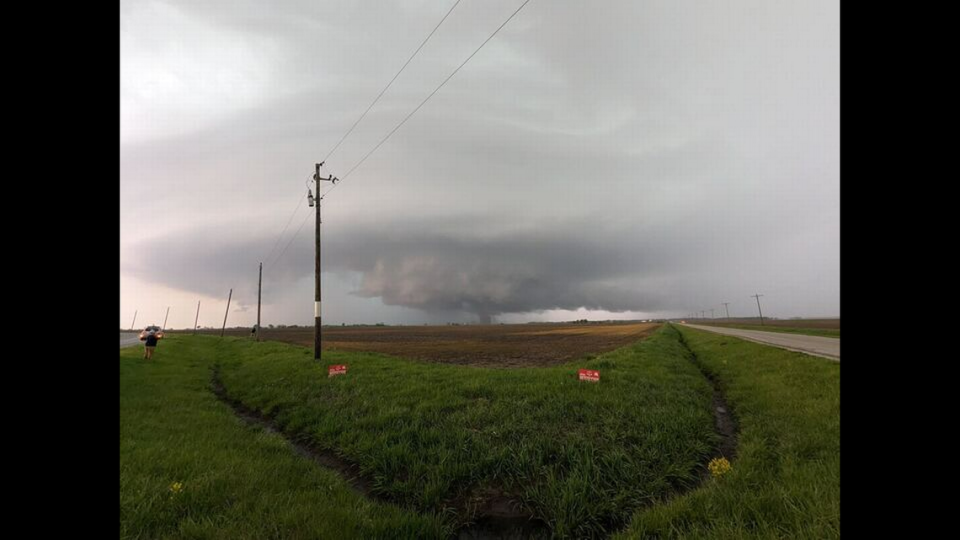
“During the afternoon and evening of April 18, 2024, discrete supercell thunderstorms developed along a cold front moving through the bi-state area,” according to the weather service. “ These storms were initially mainly capable of producing large hail and damaging wind gusts, but become tornadic as additional thunderstorms formed along the front.
“Due to the additional thunderstorms, storm interaction increased, causing storms to congeal into a Quasi-Linear Convective System (QLCS) that impacted the St. Louis metro area and portions of southwestern Illinois.”
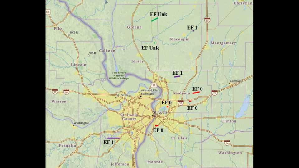
Confirmed tornadoes hit the following areas in Illinois and Missouri, according to a weather service report. The quoted passages at the end of each entry are from the report.
High Ridge, MO: EF1 tornado from southwest of Eureka to High Ridge in Missouri. Estimated peak wind of 100 mph, 7.78 miles in length, 40 yards wide. Started at 5:30 p.m. and ended at 5:39 p.m. Summary: “The tornado touched down in a subdivision southwest of Eureka in rural St. Louis County where it caused minor tree damage. The tornado moved east across the Meramec River into Jefferson County where it damaged two large metal outbuildings and snapped wooden electrical poles on Twin River Rd Between the Meramec and Big Rivers. The tornado continued to the east where it caused tree damage before lifting southeast of High Ridge.”
Prairietown, IL (Madison County) EF1 tornado in Dorsey to Prairietown in Madison County, Illinois. Estimated peak wind of 95 mph, 3.14 miles in length, 125 yards wide. Started at 5:57 p.m. southeast of Dorsey and ended at 6:01 p.m. near Prairietown. Summary: “A tornado touched down on a farm at the end of Cooper Rd. southwest of Prairietown, IL causing roof damage to outbuildings and tree damage. The tornado continued east causing more tree damage along North State Route 159 near the intersection of Sawmill Run. The tornado continued to the east where it damaged the roof and siding of a farm house and outbuildings off of Prairietown Rd before lifting.”
Pontoon Beach, IL (Madison County) EF0 tornado with winds up to 80 mph struck south of Pontoon Beach in Madison County, Illinois. Estimated peak wind of 80 mph, .91 mile in length, 100 yards wide. Started at 5:52 p.m. southwest of Pontoon Beach and ended at 5:53 p.m. south/southeast of Pontoon Beach. Summary: “The tornado touched down near the west end of Arlington Dr south of Pontoon Beach IL. The tornado damaged trees along its 0.9 mile path to the east along Arlington Dr.”
Marine, IL (Madison County) EF0 tornado with estimated peak wind of 80 mph, 6.8 miles in length (initial report was 4.4 miles), 125 yards wide from Loos Road just west of Illinois 4 to near Brothers Lane just north of Marine in Madison County, Illinois. Started at 6:09 pm., ended at 6:16 p.m
Marine, IL (Madison County) EF0 tornado near Marine along Lower Marine Road in Madison County, Illinois. This had maximum winds of 80 mph and was .3 miles long.
Cahokia IL (St. Clair County) EF0 tornado with estimated winds up to 76 mph. It was 35 yards wide and 1.1 miles long . It started at 5:58 p.m. and ended at 5:59 p.m. “The tornado touched down near the western edge of the Prairies of Cahokia Golf Course and moved east for about 1.1 miles where it lifted near the intersection of Carol Rd and Lynn St. Damage consisted of uprooted trees and broken tree limbs.”
Standard City, IL (Macoupin County) EF1 tornado with estimated winds of 95 mph. The maximum width was 75 yards and the path length was .23. It started at 5:52 p.m. and ended at 5:53 p.m. “A brief tornado touched down south of Standard City where it damaged the roofs of 3 farm sheds. The tornado moved southeast across South Standard City Rd where it caused tree damage before lifting. “
Athensville, IL (Greene County) EFU The rating, peak width and maximum width are unknown. The length of the path was 4.3 miles. It started at 4:51 p.m. and lifted at 5:04 p.m. “Numerous pictures and videos recorded the tornado, although no damage was observed.”
Kemper IL (Jersey County) EFU The rating, peak and width are unknown. It started and ended at 5:36 p.m. “Storm spotter observed a brief touchdown in a field west of Kemper. No damage was observed.”
The weather agency described the tornadoes as “weak.”
The National Weather Service said Friday that two survey teams were checking on storm damage and that more tornadoes may be confirmed in the coming days.
This is the Enhanced Fujita Scale the agency uses to grade the severity of tornadoes:
EF0: 65 to 85 mph
EF1: 86 to 110 mph
EF2: 111 to 135 mph
EF3: 136 to 165 mph
EF 4: 166 to 200 mph
EF 5: Greater than 200 mph
A grandstand at the World Wide Technology Raceway in Madison was knocked onto the drag strip during storms Thursday, and the track has canceled drag racing scheduled for this weekend.
“The west grandstands of the World Wide Technology Raceway drag strip suffered extensive and permanent damage due to high winds,” the track said in a news release Friday. “As a result, the drag strip will be inoperable this weekend while facility operations clear the track’s racing surface.”
Races scheduled for late April and early May will take place, the news release said.