Hurricane Lee recap: How New Bedford and Fall River areas are preparing for storm's impacts
Find the latest coverage on Lee's impact in Rhode Island on Saturday, Sept. 16 here:
Across the SouthCoast, safety officials and the public are bracing for the potential effects of Hurricane Lee, making its way north along the Eastern Seaboard.
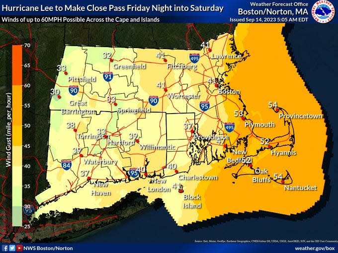
The National Weather Service has instituted a tropical storm warning until further notice for the SouthCoast, and a high surf warning until 8 a.m. Saturday. It said that as of 5:15 p.m. Friday, Lee was less than 300 miles southeast of Nantucket and headed north at 20 mph. Lee is a Category 1 storm with winds of 80 mph.
Winds are expected to increase tonight and remain gusty through Saturday night. Tropical storm-force winds are expected late tonight and Saturday near the coast.

Here are some other developments and information to know:
What is Hurricane Lee's track
State of Emergency declared ahead in Massachusetts of Hurricane Lee to help with response
Gov. Maura Healey declared a State of Emergency in Massachusetts on Friday and is requesting that FEMA issue a pre-disaster emergency declaration, she made the announcement during a noon press conference. A state of emergency and an emergency declaration makes Massachusetts eligible for direct federal assistance for response costs, personnel, equipment, supplies and evacuation assistance.
Healey activated 50 National Guard troops for storm preparation and to be prepared to respond with high-water vehicles if needed.
Healey: 'Even small amounts of rain can have a big impact': MA governor prepares for Hurricane Lee
The Massachusetts Emergency Management Agency opened its state of emergency operation center at its Framingham headquarters at 7 a.m. The state will also set up operation centers in Franklin and Tewksbury to support local and state agencies and organizations.
The Massachusetts Department of Transportation is telling residents to plan ahead and to stay off the roads in the height of the storm.
~ Kinga Brody, Massachusetts Statehouse reporter with the Worcester Telegram.
Stakeholder briefing: power outage estimates
Carl Sawejko, coordinator of Emergency Management Services for Swansea, was on the statewide briefing coordinated by MEMA and the National Weather Service at 3 p.m. Friday.
Sawejko said that storm officials anticipated that affects of the storm will likely be minor to moderate, and wind gusts could peak early Saturday.
Storm officials also indicated, according to Sawejko, that utility company Eversource anticipates that at the peak of the storm 140,000 could be impacted with National Grid estimating that at the height, 139,000 of its customers could be impacted.
Watching the tide cycles
According to information provided by NOAA, the closest Hurricane Lee’s approach to the region will be Saturday morning about 200 miles off the coast of Cape Cod.
NOAA is watching two high tide cycles at 12:30 a.m. until 1:30 a.m and again at 1:30 p.m. until 2 p.m. on Saturday. See the NOAA Coastal Flood Threat Display HERE
“Given the faster forward motion of Lee, we have above average confidence that water levels will be higher with the first high tide cycle late tonight than the one Saturday afternoon,” according to NOAA.
The probability of any pockets of moderate flooding Saturday afternoon will be lower than the earlier high tide.
How big is Hurricane Lee?
Lee had a diameter of tropical storm force winds or higher across 564 miles early this morning, with winds of hurricane force spanning 184 miles. The tropical wind field is larger than the equivalent of 15 Rhode Islands if you measure from the state from east to west, and larger than 3 Massachusetts, again measuring east to west.
How big is Hurricane Lee?: It's as wide as the state of Montana and 15 Rhode Islands
Coast Guard: 'Hurricane Port Condition X-ray.'
At 9:36 a.m. on Friday, the U.S. Coast Guard announced on social media that all ports throughout New England are in a heightened state of caution known as "Hurricane Port Condition X-ray." According to govinfo.gov, Condition X-ray is activated when weather advisories indicate sustained wind force of 39 to 54 mph, known as gale force winds, from a tropical storm or hurricane expected to make landfall at a port within 48 hours.
"All ports are open to commercial traffic, but vessel planning is necessary," USGC wrote in its post on X, formerly known as Twitter.
Flight delays at Logan Airport in Boston and T.F. Green in Providence
As of Friday morning, both major airports are showing limited delays and cancelations for Friday night and Saturday morning flights. Cape Air has canceled its 4:50 p.m. Friday and 6 p.m. Friday flights from Logan to Bar Harbor, Maine.
The message on Logan’s website says “Due to expected weather conditions, passengers are advised to check with their airline on the status of their flight before coming to the airport: https://loom.ly/OZ0LePU”
Hurricane Lee: Canceled events, postponements in the New Bedford area
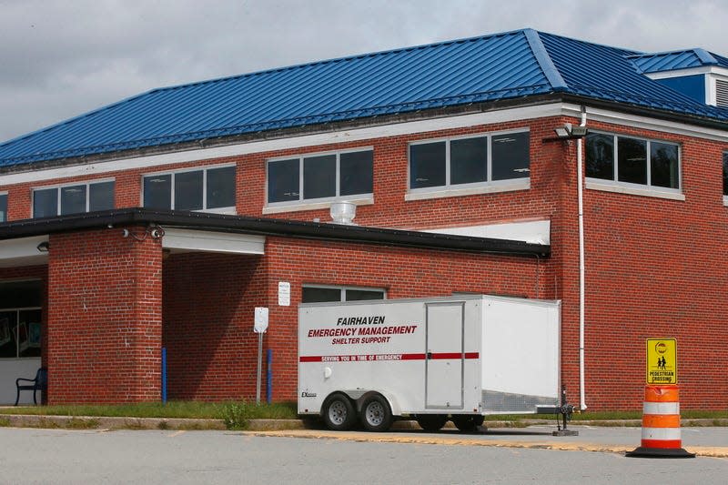
Earlier Friday: West Island, Sconticut Neck residents should get hurricane passes ASAP
Fairhaven residents of West Island and Sconticut Neck Road were advised to obtain hurricane passes. The passes would be needed for them to return to their homes in case of an evacuation. In that event, residents looking to return to their homes afterward would not be permitted past a checkpoint set up at the Wood School, 60 Sconticut Neck Rd., without a pass, Fire Chief Todd Correia said.
Hurricane passes were available at the BPW building at 5 Arsene St., or the Fire Department Business Office at 146 Washington St.
Acushnet Fire Department training to provide coincidental backup
Acushnet Fire Chief Thomas Farland on Friday said due to a department training scheduled for Saturday, there'd be enough extra personnel at the station to handle any storm-related needs without the need for any special scheduling.
"They'll be here till 1 p.m., and the worst of the storm should be past us by 2 p.m.," he said, noting the storm's continued movement east was good news for SouthCoast.
"I think the biggest issue we're going to see in our general area of the state, because the trees are still full of leaves, will be branches falling and things like that."
Is the Hurricane Barrier in New Bedford going to close?
The U.S. Army Corps of Engineers said Friday morning that there were no plans to close any of the three New England hurricane barriers, including the one in New Bedford's South End.
"Water levels, conditions and the latest forecasts will be closely watched during this storm’s approach, and we will be prepared to conduct barrier closure operations, if necessary," wrote Bryan Purtell of the USACE Public Affairs Office in an email.
"Our hurricane barrier staff will be on site a minimum of three hours in advance of any large projected high tide event because real time observations on site are considered with weather forecasts to drive our decision making when it comes to closing a hurricane barrier."
The other two New England barriers are in Providence and Stamford, CT.
View USACE updates via social media at twitter.com/corpsnewengland and facebook.com/CorpsNewEngland.
Live view: See Hurricane Lee impacts as they happen in the Fall River and New Bedford area
Seastreak cancels ferry service Friday and Saturday
Seastreak canceled ferry service for Friday and Saturday. Anyone with questions is advised to call 1-800-BOATRIDE or email contactnb@seastreak.com.
MassDOT announced lane closures in New Bedford
On social media, Mass. Department of Transportation said Route 140 lane closures for daytime drainage and erosion repairs began at 7 a.m. Friday and would continue through 3:30 p.m. This affects southbound travelers in the area of the Exit 2 ramp, to I-195W, and Exit 3, to Hathaway Boulevard.
MassDOT has not confirmed whether or not the work was related to preparations for Lee.
8 biggest storms: What are the biggest hurricanes to hit Massachusetts?
Where Lee is supposed to strike and when
The latest National Hurricane Center projections show Lee is expected to travel north and make landfall at Nova Scotia, Canada, late Saturday.
"Hurricane Lee has been moving faster now than it has all week long. It is moving away from Bermuda as a Category 1 hurricane and through Friday night, it is going to maintain that strength," said meteorologist Cindy Fitzgibbon from WCVB, a media partner of the Standard Times and Herald News on Friday morning. "Tropical storm force sustained winds are possible on parts of the outer Cape, where we could see gusts 50 to 60 miles per hour."
Fall River and New Bedford ready to weather the storm
City officials have been closely monitoring Lee's progress and taking the necessary precautions.
In Fall River, Department of Community Management Director Charlie Denmead said the city has 300 sandbags from MEMA and were anticipating 500 more on Friday from MEMA. The city also has the capacity to fill 1,500. On Friday morning Denmead said they will receive 300 more.

“We’ll fill hundreds of bags, up to 1,500 depending on the size of the storm,” said Denmead. If residents need them they can call DCM to pick them up.
In New Bedford, all city beaches, CoveWalk, HarborWalk, Fort Taber and city-operated boat ramps were be closed to the public on Friday at 8 p.m.
A determination has not yet been made whether to close the city’s hurricane barrier. The New Bedford Port Authority encouraged all vessel owners to make arrangements for berthing or hauling in the harbor as far in advance of the arrival of storm conditions as possible.
What's new Friday:
On Friday morning, Carl Sawejko, coordinator of Emergency Management Services for Swansea, said, "We're looking at this as a heavy rainstorm-type event" adding they don't anticipate more rain and wind than they've gotten in previous storm and don't anticipate any more flooding then they get in a normal storm.

Live view: See Hurricane Lee impacts as they happen in the Fall River and New Bedford area
A beautiful day today; not so much this weekend. On account of #HurricaneLee, we are closing our beaches and waterside walkways beginning tomorrow evening. Here’s more about what #newbedford is doing: pic.twitter.com/iQqahgEl5R
— Jon Mitchell (@JonMitchellNB) September 14, 2023
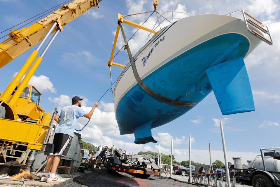
Protect your boat ahead of the storm
Earlier this week, many local harbormasters were advising boat owners to haul their vessels out of the water sooner rather than later. While some marinas had not seen a rush of activity, the Dartmouth harbormaster noted in a statement that “it's easier on everyone if your boat is put away for the winter. Have it hauled yesterday!”

On Thursday, the Fairhaven harbormaster noted that there's still time for boat owners to get their vessels on dry land: "We've told people, if you have a trailer, especially down West Island, pull out."
How to prepare your home: Take these steps to help prevent damage

How to prepare for a possible weather disaster
For anyone who needs to get ready for the storm, any last-minute prep should be done right now.
The first thing to do: Prepare for a power outage by having flashlights and spare batteries on hand, and make sure they work. Make it part of your emergency disaster kit – something portable in case you have to evacuate.
Flooding is likely to occur if Lee dumps heavy rain on the region; flooding can also be dangerous and has its own set of challenges. Read on to learn more about how to protect yourself and loved ones.
'Have it hauled yesterday': SouthCoast harbormasters watching track of Hurricane Lee
Sailors take warning: 'The tidal surge is usually the biggest culprit' says local harbormasters
What is a storm surge, and when are the next predicted high tides?
According to the National Hurricane Center, a storm surge is when a storm generates a high water level above the predicted astronomical tide. Currently, Southeastern Massachusetts, include the Cape and Islands, are in a storm surge watch.
During the brunt of the storm, the SouthCoast area will see high tide at 9:11 p.m. on Friday. Low tide is overnight at 2:44 a.m. Saturday, with another high tide at 9:34 a.m.
Storm Surge map
Emergency numbers to know:
To report a downed power line, medical, fire, or other emergencies, dial 911
Eversource: 800-592-2000
National Grid: 800-465-1212
Verizon: 800-VERIZON
Comcast: 800-XFINITY
Police non-emergency lines:
Acushnet: 508-998-0240
Dartmouth: 508-910-1700
Fairhaven: 508-997-7421
Fall River: 508-676-8511
Freetown: 508-763-4017
New Bedford: 508-991-6350
Somerset: 508-679-2138
Swansea: 508-674-8464
Westport: 508-636-1122
New Bedford Department of Public Infrastructure: 508-979-1550
Fall River Department of Community Maintenance: for downed trees or branches, 508-324-2762; for sewer/storm drain flooding, 508-672-4530; for Water Department-related issues, 508-324-2721
This article originally appeared on The Herald News: Hurricane Lee Live: New Bedford, Fall River weather predictions, prep

