Summit County under Level 1 snow emergency, rain expected in Akron area this afternoon
Most major roads and highways are clear after snow in Greater Akron Wednesday morning, but rain is expected throughout the afternoon in the area.
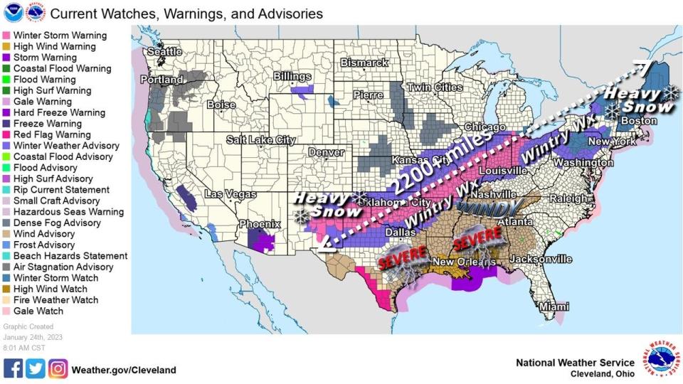
The weather service issued a winter storm warning for extreme western Ohio on Tuesday and a winter weather advisory for all of northern Ohio. Summit County is also under a Level 1 snow emergency advisory as of Wednesday morning.
Driving in northern Ohio this winter?:These tips will help you get there safely
Last weekend:Winter storm dropped an inch an hour Sunday
Here are the latest updates:
Current road conditions in Greater Akron
The city of Akron said it had all available trucks and equipment pre-treating Tuesday night into Wednesday morning ahead of the storm.
As of just before 9 a.m. Wednesday, most major roads are wet and clear, according to OHGO, the Ohio Department of Transportation's traffic website, and traffic is normal in Akron but slower to the south, according to Google Maps.
Around 6:50 a.m., I-71 south just south of I-76 was closed after a semi truck appeared to be on its side, blocking traffic. Around 12:20 p.m. all lanes were clear except for the right lane which still required crews for cleanup.
Around 8:40 a.m., a crash on I-77 north beyond SR-261/Vernon Odom Blvd was blocking the left lane of traffic. Around 9:15 a.m. the lane was open.
I-71 south just south of I-76 closed. Semi on its side blocking the entire interstate. Backup is building quickly. pic.twitter.com/1ohyC6AMJb
— Mike Vielhaber (@MVielhaber) January 25, 2023
Snow is moving into northeast Ohio. Check out these views from OHGO traffic cameras in Stark, Summit & Mahoning counties this hour. Ashtabula still looking dry (for now). If you plan to head out this morning, be sure to check https://t.co/G3YX2D3hVN. #ohwx pic.twitter.com/CAqLRrIJti
— ODOT Akron (@ODOT_Akron) January 25, 2023
Traffic camera:View I-77 near Akron-Canton Airport
Traffic camera:View camera at Akron Central Interchange (I-77-76)
ODOT updates:View the latest ODOT-Akron information
Akron area school closings
Akron Public Schools posted on Facebook at 6:17 a.m. Wednesday that the district will be closed Wednesday. The STEM High School and Akron Early College High School have to follow the University of Akron closing protocols.
Cuyahoga Falls City Schools also posted on Facebook that schools would be closed Wednesday due to inclement weather.
Check this link for the latest on school closings in the Akron area.
What we know:Are Akron schools closed? Here's the list of closings and delays
What warnings and emergencies are in effect?
The weather service on Tuesday issued a winter storm warning for extreme western Ohio and a winter weather advisory for all of northern Ohio.
Wednesday morning, Summit County Sheriff Kandy Fatheree issued a Level 1 snow emergency advisory.
Snow emergency levels:What they mean as the Ohio winter trudges along
How long will the warnings last?
The winter weather advisory for northern Ohio is set to lift at 3 p.m. Wednesday.
How much snow fall is expected in Akron?
Snowfall rates of an inch an hour are possible around the region for the Wednesday morning commute. Snowfall amounts will vary as some rain is expected to mix in by Wednesday afternoon in Greater Akron. The weather service says a general snowfall of 3 to 4 inches is expected across northern Ohio through Wednesday afternoon. Greater snowfall totals of some 8 inches are expected in Toledo where it will be all snow. More snow is expected Thursday into Friday with as much as 4 inches of additional snow possible.
Be mindful heating your home:What to know about carbon monoxide poisoning, detection
When will the snow end?
The snow is expected to start around 3 a.m. Wednesday morning and continue through the morning hours. It is expected to switch over to a wintery mix by the afternoon and then rain through the evening. By 2 a.m. Thursday morning, it switches back over to snow. The weather service says snow showers are expected Thursday and continuing through Friday.
Power outages in Greater Akron
There are very few power outages in the Greater Akron area as of 6:15 a.m. Wednesday, according to FirstEnergy. In Summit County, there are fewer than five outages, all in Green, and zero outages in Stark, Medina, Portage and Wayne counties.
Ohio Edison power outages can be reported online or by calling 888-544-4877.
First Energy:Map of power outages in Akron area
AEP:Canton-area power outages map
Akron-Canton and Cleveland Hopkins airport status
Cleveland Hopkins International Airport and Akron-Canton Airport are operating close to normal, according to their websites.
The Cleveland airport has one delayed departing flight — a 6:30 a.m. Southwest flight to Chicago (528), delayed from 6:30 a.m. to 7 a.m. — and three canceled departing flights: an 11:25 a.m. Southwest flight to Chicago (1887), a 3:25 p.m. Southwest flight to Chicago (536) and a 4:15 p.m. Air Canada flight to Toronto (8736). The Cleveland airport also has no delayed arriving flights listed and three canceled arriving flights: a 10:45 a.m. Southwest flight from Chicago (532), a 2:45 p.m. Southwest flight from Chicago (534) and a 3:37 p.m. Air Canada flight from Toronto (8733). The Akron airport has one delayed departing flight, a 6:21 a.m. American Airlines flight to Charlotte (5495), and no delayed arriving flights.
CAK:Current arrival and departure information
CLE:Current arrival and department information
Akron weather forecast and timeline
This is the current forecast:
Wednesday: Rain and snow, becoming all rain after noon. The snow could be heavy at times. High near 40. Breezy, with an east wind 11 to 20 mph. Chance of precipitation is 100%. New snow accumulation of 1 to 3 inches possible.
Wednesday night: Rain likely before midnight, then snow showers likely, possibly mixed with rain between midnight and 1 a.m. , then snow showers likely after 1 a.m. Cloudy, with a low around 30. South wind 15 to 18 mph becoming west after midnight. Chance of precipitation is 70%. New snow accumulation of less than a half inch possible.
Thursday: Snow showers likely, mainly between 7 a.m. and 1 p.m. Cloudy, with a high near 31. West wind 10 to 15 mph. Chance of precipitation is 60%. New snow accumulation of around an inch possible.
Thursday night: A chance of snow showers. Cloudy, with a low around 21. Chance of precipitation is 50%. New snow accumulation of 1 to 2 inches possible.
Friday: Mostly cloudy, with a high near 31.
Friday night: Snow showers likely before 1 a.m., then a chance of rain and snow showers. Cloudy, with a low around 28. Chance of precipitation is 60%.
This article originally appeared on Akron Beacon Journal: Winter weather advisory in effect: Afternoon rain expected in Akron

