Leaf collection, VDOT fixes to Rte 250, South River access at Crimora Park, more: THE DIGEST
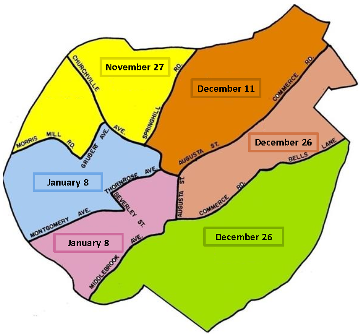
Here's when leaves will be collected in Staunton
STAUNTON — In an effort to assist residents with fallen leaves, the city of Staunton is kicking off its annual leaf collection program beginning in November and continuing through early January, according to a press release.
Residents who would like to participate should rake their leaves to the curb or street right-of-way, away from gutters, and remove rocks and debris prior to the beginning of their scheduled pickup. The city will not attempt to collect leaf piles containing debris as they can damage the machinery.
Final pickup dates can be determined using the map provided. Crews will be out before those dates to collect any leaves that are out early, but the dates indicated are the final pass for each zone. Leaves must be at the curb by 7 a.m. on the final day for them to be picked up.
Be aware that winter events and other priorities may take precedence and leaf collection will not occur on city holidays, including Nov. 26-27. Dec. 22, and Jan. 1.
Individual street schedules cannot be provided, the release said. The city will provide the collected leaves to local farms for composting. Any questions about the program can be directed to public works at 540-332-3892.
How's VDOT going to improve Rte. 250? Come to the open house to find out.
VDOT schedule November 8 citizen information meeting for West Main Street improvements in Waynesboro
WAYNESBORO — The Virginia Department of Transportation (VDOT) will hold a citizen information meeting concerning corridor improvements to West Main Street (Route 250) in the city of Waynesboro, according to a press release. The open house meeting will take place from 4 p.m. to 6 p.m. Wednesday, Nov. 8, in Waynesboro City Council chambers at the Charles T. Yancey Municipal Building, 503 W. Main St. in Waynesboro.
Citizens can come in during the meeting hours and discuss the project on a one-on-one basis with VDOT officials and designers. Written comments can be submitted at the meeting or within 10 days after the meeting date to Jennifer Hoover, Project Manager, Virginia Department of Transportation, 811 Commerce Road, Staunton, VA 24401-9029.
The purpose of this project is to improve operational safety for the West Main Street (Route 250) corridor in Waynesboro between Hopeman Parkway and the western city limits. This portion of West Main Street currently has two through-lanes in each direction and a two-way left-turn lane in the center of the roadway.
This project will replace the center turn lane with raised medians that allow left turns only at designated median openings. Most of the commercial access driveways and side streets will be restricted to right turns in and out. This will reduce crashes by restricting the amount of full access points onto West Main Street.
Multimodal improvements include a proposed sidewalk, crosswalks, ADA-compliant facilities, and traffic signal modifications. The project will be located within the city of Waynesboro, between the western city limits (near Lew Dewitt Boulevard) and Hopeman Parkway.
A Strategically Targeted Affordable Roadway Solutions (STARS) study of Route 250 in Waynesboro and Augusta County was completed in 2020. This segment of West Main Street was included in the study and recommended for operational and safety improvements.
This project complements a separately funded project for BRITE (Blue Ridge Intercity Transit Express) bus stops.
In 2021 West Main Street had an average traffic count of 18,300 vehicles per day. By the design year of 2048 the estimated daily traffic volume is 20,600 vehicles per day.
The total estimated cost of this project is $12,574,828 which includes $726,164 for preliminary engineering, $1,516,365 for right of way acquisition and utility relocation, and $10,332,299 for construction. This project was selected for funding under the SMART SCALE process for prioritizing transportation projects.
Additional information about the West Main Street project is found on the VDOT website at: https://www.virginiadot.org/projects/staunton/city-of-waynesboro-8211-west-main-street-corridor-improvements.asp.
South River access opens this week at Crimora Park
AUGUSTA COUNTY — On Nov. 2 at 11 a.m. Augusta County will celebrate the grand opening of Crimora Park’s South River access point, according to a press release. Crimora Park represents Augusta County’s second river access point and a year-long collaborative effort between federal agencies, state partners and local and regional organizations. Completely funded through grants, this river access expands Augusta County Parks and Recreation department’s offerings and improves opportunities for recreation, fishing, tubing and boating.
Director of Parks and Recreation, Andy Wells, elaborated, “Prior to April 2022, when our first river access spot at Dooms Crossing officially opened, there was no publicly accessible spot in Augusta County where one could fish or launch a canoe on the South River. With Dooms and now Crimora, we can more fully enjoy the benefits of our county’s natural amenities.”
Overview, funding and usage
Crimora Park is located along the South River at the site of the former Crimora Elementary School. Since 2011 when the property was developed into a park, Parks and Recreation staff repeatedly heard from park users that improved river access was needed, a desire highlighted in a 2019 public interest survey.
“Public input for Crimora gave us guidance on the most important features to focus on,” said Doug Wolfe, Community Development director and senior engineer during the project’s start. “Grant funding made it possible to improve the park’s recreational access at little cost to the county.”
The park boasts 500 feet of accessible river frontage and more than two acres of flood plain open space. It is approximately 4.5 miles downstream from Dooms Crossing, which is the closest public put-in, and 7.5 miles downstream from Waynesboro’s Basic Park access.
While Crimora had been previously used for boat launch and fishing, the site was not accessible or easy to use. New roadway access now provides closer parking for put-in and take-out of paddle watercraft and an improved gravel walking trail leads directly to the canoe ramp. Parking lot improvements include installation of storm sewer to carry storm water under the parking lot; installation of heavy-duty, steel-backed timber guardrails; and the paving and striping of 14 parking spaces, which includes room for trailer parking.
In 2018, between the Dooms Crossing and Crimora Park projects, county engineers combined three separate grants for a total funding amount of $481,555 from the Natural Resource Damage Assessment and Restoration (NRDAR) process to restore and preserve the waterway and provide citizens with opportunities for recreation. The portion of grant funding for Crimora Park’s river access project was $120,000.
The river access projects initially focused on improving water quality and fish habitat. In the Dooms Crossing portion of the project, Augusta County worked with the Virginia Department of Wildlife Resources (DWR) and the Virginia Department of Environmental Quality (VDEQ) to remove the remnants of a failed dam, which created navigational hazards for boaters and impediments for fish migrating upstream to the headwaters of the South River to spawn. Additionally, eroding banks needed significant restoration and re-stabilization. The project’s focus then shifted to recreational enhancements at both Dooms and Crimora. The Dooms Crossing river access site opened on April 20, 2022.
Crimora Park’s South River access will be open from dawn to dusk for fishing and launching kayaks, canoes and other non-motorized boats. For everyone’s enjoyment and safety, the following activities are prohibited: fires, consumption of alcoholic beverages, camping, trespassing after/before hours, and the discharge of firearms. For information on fishing licenses, fish consumption advisories, and fishing regulations, see the Virginia Department of Wildlife Resources page at https://dwr.virginia.gov/fishing/.
Environmental, economical impacts
Middle River magisterial district’s Board of Supervisor, Gerald Garber, noted, “Convenient and accessible river access sites, such as this one in Crimora, provide recreational, social and economic benefits to communities. These boat launch and fishing sites will attract a growing audience and introduce folks to what Augusta County has to offer, hopefully benefitting economic sectors, such as lodging, outdoor recreation, retail and food services.”
South River access in Dooms and Crimora improves Augusta County’s ability to attract outdoor enthusiasts and anglers. The river is home to a diverse and vibrant wildlife population for fishing, hunting, and wildlife watching. The American eel, brook trout, and freshwater mussels along with bald eagles and a variety of river birds, including two species with state or national level conservation status, call the South River home. The river access projects help to conserve the water quality, aquatic habitats, and wildlife and fish populations of the South River.
South River access in Dooms and Crimora improves Augusta County’s ability to attract outdoor enthusiasts and anglers. The river is home to a diverse and vibrant wildlife population for fishing, hunting, and wildlife watching. The American eel, brook trout, and freshwater mussels along with bald eagles and a variety of river birds, including two species with state or national level conservation status, call the South River home. The river access projects help to conserve the water quality, aquatic habitats, and wildlife and fish populations of the South River.
Natural Resource Damage Assessment and Restoration (NRDAR)
NRDAR is the result of a settlement agreement between the federal Fish and Wildlife Service and the Commonwealth of Virginia and DuPont that provides funding for restoration of wildlife habitats that were impacted by the release of mercury from the former Dupont facility in Waynesboro over 70 years ago. Mercury entered the South River and South Fork Shenandoah River as well as the habitat next to the rivers and impacted the fish and wildlife living in these habitats as well as the recreational use of the rivers for many years.
Visit the county projects webpage for more information about Augusta County’s South River access sites in Dooms Crossing and Crimora Park.
Fire-Rescue survey for Augusta County now open through Nov. 10
Augusta County is seeking public feedback on fire-rescue services as part of the development of its Fire-Rescue strategic plan. The county is working with the Center for Public Safety Management to assess the current system and create a master plan for continuous improvement of services.
“We want to ensure that all community members have access to the best possible fire-rescue services,” said Tim Fitzgerald, county administrator. “We are asking for feedback from residents so that we can better understand their experiences with our system and make sure we are meeting their needs.”
The county encourages all residents to participate in the survey which is available online at www.AugustaCountyVA.gov/FireRescueSurvey through Nov. 10. Paper copies of the online survey are also available at the Government Center in Verona and at all Augusta County libraries.
Turning a closed shoulder: Roadwork, roadwork, roadwork . . .
Lots of closed shoulders across our reading area this week as Virginia Department of Transportation Crews are working on everything from sinkhole repairs to pavement marking to utility work and construction of turn lanes.
INTERSTATE 64
*NEW* Mile marker 93 to 94, eastbound – Left shoulder closures, 7 a.m. to 7 p.m. Monday. Left lane closure from 7 p.m. Monday night until work is complete. Traffic restrictions are for sinkhole repairs.
INTERSTATE 81
Mile marker 211 to 207, southbound – Overnight single lane closures for pavement marking operations, 8 p.m. to 9 a.m. through Sunday night (October 29).
Mile marker 220 to 222, northbound – Overnight alternating lane closures for maintenance to bridge over eastbound I-64, 8 p.m. to 7 a.m. through Friday night.
*UPDATE* Mile marker 221 to 225, northbound and southbound – Possible shoulder closures for sign installation, including along interstate ramps, 7 a.m. to 5 p.m. Monday to Friday.
Mile marker 221 to 223, northbound – Overnight single lane closures for maintenance to bridge over Route 250 (Jefferson Highway), 7 p.m. to 8 a.m. through the night of November 21.
Mile marker 223 to 227, northbound and southbound – Overnight alternating lane closures for inspection of bridges over Lewis Creek, 8 p.m. to 7 a.m. through the night of November 29.
*NEW* Mile marker 226 to 227, northbound – Right shoulder closures for sign work, 8 a.m. to 5 p.m. Monday through Friday.
Mile marker 226 to 229, northbound and southbound – Overnight single lane closures for maintenance to Route 612 (Laurel Hill Road) overpass bridge, 8 p.m. to 7 a.m. through the night of December 24.
*NEW* Mile marker 230 to 229, southbound – Right shoulder closures for sign work, 8 a.m. to 5 p.m. Monday through Friday.
PRIMARY ROADS
Route 11 (Lee Highway) – Northbound 24/7 shoulder closures near intersection with Route 256 (Weyers Cave Road) for turn lane construction, estimated completion in May 2024. Flagger traffic control as needed for nighttime and overnight work.
Route 56 (Tye River Turnpike) – Flagger traffic control between Route 11 (Lee-Jackson Highway) and Rockbridge County line for paving operations, 6:30 a.m. to 8 p.m. through November 17.
*UPDATE* Route 252 (Middlebrook Road) – Flagger traffic control between Route 819 (Bittersweet Lane) and Route 710 (Mill Lane) for utility work, 9 a.m. to 2:30 p.m. Monday through Thursday.
Route 256 (Weyers Cave Road) – Shoulders closed 24/7 between Route 11 (Lee Highway) and Route 2011 (Triangle Drive). Traffic restrictions are for construction of turn lanes with estimated completion in May 2024.
Route 256 (Weyers Cave Road) – Overnight flagger traffic control between Route 11 (Lee Highway) and Route 2003 (Wayside Drive/Triangle Drive) for paving operations, 8 p.m. to 6 a.m. nights through November 16.
Route 262 (Woodrow Wilson Parkway) – Northbound and southbound shoulder closures approaching I-81 ramps just south of Staunton for sign installations, 7 a.m. to 5 p.m. Monday through Friday.
Route 340 (Stuarts Draft Highway/Rosser Avenue) – Shoulder closures for sign installations near I-64 interchange (Waynesboro) and intersections with Route 11 (Lee-Jackson Highway) and Route 608 (Tinkling Spring Road/Draft Avenue), 7 a.m. to 5 p.m. Monday through Friday.
Route 340 (Stuarts Draft Highway) – Flagger traffic control between Route 655 (Walnut Hills Road) and Route 652 (University Farm Road) for paving operations, 6:30 a.m. to 8 p.m. through November 17.
Route 340 (East Side Highway) – Northbound and southbound single lane closures and flagger traffic control as needed between Route 612 (Crimora Mine Road/New Hope-Crimora Road) and Route 1343 (Northwood Drive) for paving operations, 6:30 a.m. to 8 p.m. through November 17.
SECONDARY ROADS
*NEW* Route 611 (Dooms Crossing Road) – Flagger traffic control between Route 340 (East Side Highway) and Route 619 (Purple Cow Road) for utility work, 9 a.m. to 2:30 p.m. Monday through Thursday.
Route 612 (Laurel Hill Road) – Westbound right lane closures between Route 1906 (Lodge Lane) and Route 11 (Lee Highway) for pedestrian access improvements, 7 a.m. to 5:30 p.m. through February 2024.
Route 624 (South Delphine Avenue, Waynesboro) – Shoulder closures between South Oak Lane and Chinquapin Drive for work related to construction of Waynesboro Southern Corridor, through May 30, 2025.
Route 664 (Lyndhurst Road, Waynesboro) – Shoulder closures between Miami Avenue and Purdue Street for work related to construction of Waynesboro Southern Corridor, through June 30, 2025.
Route 664 (Mount Torrey Road) – Shoulder closures and occasional flagger traffic control between Route 624 (Lyndhurst Road) and Route 894 (Mount Torrey Road) for water line installation, 7 a.m. to 5 p.m. through Tuesday.
Various roads – Mobile traffic control for mowing operations. Flagger traffic control for drainage work, tree removal, shoulder repairs, pavement patching and brush cutting, 7:30 to 3 p.m. on weekdays.
This article originally appeared on Staunton News Leader: Leaf collection, VDOT fixes to Rte 250, South River access: THE DIGEST

